
Krishna district is a district in the coastal Andhra Region in Indian state of Andhra Pradesh, with Machilipatnam as its administrative headquarters. It is surrounded on the East by Bay of Bengal, West by Guntur, Bapatla and North by Eluru and NTR districts and South again by Bay of Bengal.

Coastal Andhra or Kosta Andhra is a geographic region in the Indian state of Andhra Pradesh. Vijayawada is the largest city in this region. Region share borders with Uttarandhra, Rayalaseema and Telangana. It was part of Madras State before 1953 and Andhra State from 1953 to 1956. According to the 2011 census, it has an area of 91,915 square kilometres (35,489 sq mi) which is 57.99% of the total state area and a population of 34,193,868 which is 69.20% of Andhra Pradesh state population. This area includes the coastal districts of Andhra Pradesh on the Circar Coast between the Eastern Ghats and the Bay of Bengal, from the northern border with Odisha to Rayalaseema in the south.

Machilipatnam, also known as Masulipatnam and Bandar, is a city in Krishna district of the Indian state of Andhra Pradesh. It is a municipal corporation and the administrative headquarters of Krishna district. It is also the mandal headquarters of Machilipatnam mandal in Machilipatnam revenue division of the district. The ancient port town served as the settlement of European traders from the 16th century, and it was a major trading port for the Portuguese, British, Dutch and French in the 17th century.

Nuzvid, natively spelled Nuzividu or Nuziveedu is a city in the Eluru district of the Indian state of Andhra Pradesh. It serves as the administrative headquarters for Nuzvid mandal and Nuzvid revenue division.
Pedana is a municipality and the headquarters of Pedana mandal under Machilipatnam revenue division of Krishna district of the Indian state of Andhra Pradesh. It is located at a distance of 8 km (5.0 mi) from the district headquarters, Machilipatnam.

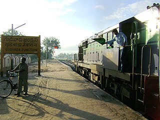
Hanuman Junction is a town which lies between the borders of Krishna and Eluru District of Andhra Pradesh state in India. Hanuman Junction gets its name because it is located in the X-Junction of NH-16 & AH-45.
Vuyyuru is a town in Krishna district of the Indian state of Andhra Pradesh. It is a Nagar panchayat and the headquarters of Vuyyuru Mandal. It is emerging as neighbourhood of Vijayawada, India situated 30 km away.
Kankipadu is a suburb of Vijayawada and a in Krishna District of the Indian state of Andhra Pradesh. It is also the mandal headquarters of Kankipadu mandal in Vuyyuru revenue division.
Avanigadda is a town in Krishna district of the Indian state of Andhra Pradesh. It is the mandal headquarters of Avanigadda mandal in Machilipatnam revenue division.

Mopidevi is a village in Krishna district of the Indian state of Andhra Pradesh. It is the mandal headquarters of Mopidevi mandal in Machilipatnam revenue division. It is one of the villages in the mandal to be a part of Andhra Pradesh Capital Region. The village is known for its famous Lord Subrahmanyeswar Swamy Temple. The village is situated 80Km from Vijayawada and 30Km from Machilipatnam.

Narasannapeta is a census town in Srikakulam district of the Indian state of Andhra Pradesh. It is the mandal headquarters of Narasannapeta mandal in Srikakulam revenue division. 43 villages are there under the administrative division of Narasannapeta.
Dokiparru is a village in Gudlavalleru mandal, located in the Krishna district of the Indian state of Andhra Pradesh. Sri Bhusametha Venkateswara Swami Temple is a popular temple in this village, making the village a pilgrimage place.
Machilipatnam railway station located in the Indian state of Andhra Pradesh, serves Machilipatnam in Krishna district. It is administered under Vijayawada railway division of South Coast Railway zone. The Vijayawada–Machilipatnam line was scheduled to be doubled by 2016. Machilipatnam railway station is categorized as a Non-Suburban Grade-5 (NSG-5) station in the Vijayawada railway division.

Nuzvid railway station, is the railway station under the jurisdiction of Indian Railways. It serves Hanuman Junction and Nuzvid town situated in the Krishna district of Andhra Pradesh. Nuzvid railway station falls under Vijayawada railway division of South Central Railway zone. It is situated on the Howrah–Chennai main line. It is one of the 27 rural stations in the state to have Wi-Fi.
Pedaprolu is a village in Krishna district of the Indian state of Andhra Pradesh. It is located in Mopidevi mandal of Machilipatnam revenue division. It is a part of Andhra Pradesh Capital Region.
The Gudivada–Machilipatnam branch line is a railway line connecting Gudivada and Machilipatnam of Krishna district in the Indian state of Andhra Pradesh. Further, this section intersects Vijayawada–Nidadavolu loop line at Gudivada.

Tarigoppula Halt railway station is an Indian Railways station in the village of Tarigoppula of Krishna district in Andhra Pradesh. It lies on the Gudivada–Machilipatnam branch line, Vijayawada–Nidadavolu loop line and is administered under Vijayawada railway division of South Coast Railway zone.
South Coast Railway Zone (SCoR) has been announced as the newest railway zone of the Indian Railways and is headquartered at Visakhapatnam, Andhra Pradesh. The formal notification for operationalization of this Zone is yet to be issued.
Morusumilli also called Morusumalli is a village in Mylavaram mandal, NTR District in the Indian state of Andhra Pradesh. It belongs to Andhra region.
Alinakhi Palem is a village near by Choragudi Panchayat present in Pamidimukkala mandal of Krishna district of Andhra Pradesh state, India. It is situated at an altitude of 09 ft above sea-level. A survey by Madras Office in 1926 by Sri Govindarajulu and LGB Firth displayed its assigned numbers. AP supplementary survey in 1965 by Sri V. Sriramulu included it in Gannavaram Taluk of Krishna district.


