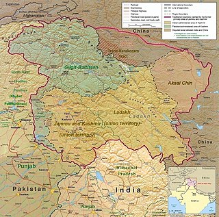
Baltistan also known as Baltiyul or Little Tibet, is a mountainous region in the Pakistani-administered territory of Gilgit-Baltistan and constitutes a northern portion of the larger Kashmir region that has been the subject of a dispute between India and Pakistan since 1947. It is located near the Karakoram and borders Gilgit to the west, China's Xinjiang to the north, Indian-administered Ladakh to the southeast, and the Indian-administered Kashmir Valley to the southwest. The average altitude of the region is over 3,350 metres (10,990 ft). Baltistan is largely administered under the Baltistan Division.

Gilgit is a city in Pakistani-administered Gilgit–Baltistan in the disputed Kashmir region. It is the capital of the Gilgit-Baltistan region. The city is located in a broad valley near the confluence of the Gilgit and the Hunza rivers. It is a major tourist destination in Pakistan, serving as a hub for trekking and mountaineering expeditions in the Karakoram mountain range.

The Karakoram Highway, also known as the KKH, National Highway 35, N-35, and the China–Pakistan Friendship Highway, is a 1,300 km (810 mi) national highway which extends from Hasan Abdal in the Punjab province of Pakistan to the Khunjerab Pass in Gilgit-Baltistan, where it crosses into China and becomes China National Highway 314. The highway connects the Pakistani provinces of Punjab and Khyber Pakhtunkhwa plus Gilgit-Baltistan with China's Xinjiang Uyghur Autonomous Region. The highway is a popular tourist attraction and is one of the highest paved roads in the world, passing through the Karakoram mountain range, at 36°51′00″N75°25′40″E at maximum elevation of 4,714 m (15,466 ft) near Khunjerab Pass. Due to its high elevation and the difficult conditions under which it was constructed, it is often referred to as the Eighth Wonder of the World. The highway is also a part of the Asian Highway AH4.

Skardu is a city located in Pakistan-administered Gilgit-Baltistan in the disputed Kashmir region. Skardu serves as the capital of Skardu District and the Baltistan Division. It is situated at an average elevation of nearly 2,500 metres above sea level in the Skardu Valley, at the confluence of the Indus and Shigar rivers. The city is an important gateway to the eight-thousanders of the nearby Karakoram mountain range. The Indus River running through the region separates the Karakoram from the Ladakh Range.

Chitral is a city situated on the Chitral River in northern area of Khyber Pakhtunkhwa. It serves as the capital of the Lower Chitral District, and was previously the capital of Chitral District, and before that the capital of Chitral princely state. The region was encompassed into West Pakistan between the years 1969 and 1972. It has a population of 49,780 per the 2017 census.

Balawaristan, is a term used for the historical region forming present-day Gilgit-Baltistan .The modern term was coined by the political party Balawaristan National Front, founded by Nawaz Khan Naji, in 1989. But it has its roots in the historical names Broshal, Dardistan and Bolor or Boloristan, with documented usage in Chinese sources from the 8th century AD. According to the present day activists, 'Balawaristan' includes Chitral, Gilgit, Skardu, Hunza, Nagar, Ishkoman, Punial and Yasin. The leader of BNF Nawaz Khan Naji declared that Balawaristan (Gilgit-Baltistan) is not part of Kashmir

Kargil or Kargyil is a city in Indian-administered Ladakh in the disputed Kashmir region. It is the joint capital of Ladakh, an Indian-administered union territory. It is also the headquarters of the Kargil district. It is the second-largest city in Ladakh after Leh. Kargil is located 204 kilometres (127 mi) east of Srinagar in Jammu and Kashmir, and 234 kilometres (145 mi) to the west of Leh. It is on the bank of the Suru River near its confluence with the Wakha Rong river, the latter providing the most accessible route to Leh.
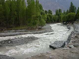
Shigar River is located in the mountainous Baltistan region of northern Pakistan. The Shigar is formed from the melted water of the Baltoro Glacier and Biafo Glacier. It flows through the Shigar Valley. The river is a tributary to the Indus River and meets the Indus in Skardu Valley. The Shigar is the main right-bank tributary of the Indus River Valley in the Skardu Valley.

Chilas is a city in Pakistani-administered Gilgit–Baltistan in the disputed Kashmir region. It is the divisional capital of Diamer Division and is located on the Indus River. It is part of the Silk Road, connected by the Karakoram Highway and N-90 National Highway to Islamabad and Peshawar in the southwest, via Hazara and Malakand divisions of Khyber Pakhtunkhwa. To the north, Chilas connects to the cities of Tashkurgan and Kashgar in Xinjiang, China, via Gilgit, Aliabad, Sust, and the Khunjerab Pass.

The Skardu District is a district of Pakistan-administered Gilgit-Baltistan in the disputed Kashmir region. Skardu District is bounded on the east by the Ghanche District, on the south by the Kharmang District, on the west by the Astore District, on the north-west by the Rondu District and on the north by the Shigar district. The district headquarters is the town of Skardu, which is also the division headquarters.
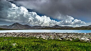
Diamer District, also spelled Diamir District,) is a district in the Gilgit-Baltistan region administered by Pakistan. The headquarters of the district is the town of Chilas. The district is bounded on the north by the Tangir and the Gilgit districts, on the east by the Astore District, on the south by the Mansehra district of Pakistan's Khyber Pakhtunkhwa Province and the Neelum District of Pakistan controlled Kashmir, and on the west by the Upper Kohistan District of Khyber Pakhtunkhwa Province. The Karakoram Highway passes through Diamer District.
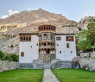
Khaplu, also spelt Khapalu, is a city that serves as the administrative capital of the Ghanche District of Pakistan-administered Gilgit-Baltistan in the disputed Kashmir region. Lying 103 km (64 mi) east of the city of Skardu, it was the second-largest kingdom in old Baltistan under the Yabgo dynasty. It guarded the trade route to Ladakh along the Shyok River east of its confluence with the Indus.

Buddhism in Pakistan took root some 2,300 years ago under the Mauryan king Ashoka who sent missionaries to the Kashmira-Gandhara region of North West Pakistan extending into Afghanistan, following the Third Buddhist council in Pataliputra.
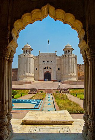
Tourism in Pakistan is a growing industry. In 2010, Lonely Planet termed Pakistan "tourism's 'next big thing'". The country is geographically and ethnically diverse, and has a number of historical and cultural heritage sites. Condé Nast Traveller ranked Pakistan The Best Holiday Destination for 2020 and also declared it the third-highest potential adventure destination in the world for 2020. As security in the country improves, tourism increases; in two years, it has increased by more than 300%.

Gilgit-Baltistan, formerly known as the Northern Areas, is a region administered by Pakistan as an administrative territory and consists of the northern portion of the larger Kashmir region, which has been the subject of a dispute between India and Pakistan since 1947 and between India and China since 1959. It borders Azad Kashmir to the south, the province of Khyber Pakhtunkhwa to the west, the Wakhan Corridor of Afghanistan to the north, the Xinjiang region of China to the east and northeast, and the Indian-administered union territories of Jammu and Kashmir and Ladakh to the southeast.
Gilgit-Baltistan is an administrative territory of Pakistan that borders the province of Khyber Pakhtunkhwa to the west, Azad Kashmir to the southwest, Wakhan Corridor of Afghanistan to the northwest, the Xinjiang Uyghur Autonomous Region of China to the north, and the Indian-administered region of Jammu and Kashmir to the south and south-east.

Chorbat Valley is a section of the Shyok river valley divided between Pakistan-administered Gilgit-Baltistan and Indian-administered Ladakh. The Pakistan-administered portion is in the Khaplu tehsil of Ghanche District in Gilgit–Baltistan, and the Indian-administered portion is in the Nubra tehsil, Leh district of Ladakh. Chorbat stretches from the edge of Khaplu to the Chalunka village of Nubra.

Khaplu Palace, locally known as Yabgo Khar, is an old fort and palace located in Khaplu, a city in Gilgit-Baltistan, Pakistan. The palace, considered an architectural heritage site and a significant tourist attraction, was built in the mid-19th century to replace an earlier-dated fort located nearby. It served as a royal residence for the Raja of Khaplu.

The Sacred Rocks of Hunza or Haldeikish constitute one of the earliest sites of Petroglyphs along the ancient Silk Route. It is a cultural heritage site in Gilgit-Baltistan region of northern Pakistan. The carvings on the rocks dates back to the 1st Millennium AD.
Strategic Highway 1 (S-1), also known as the Gilgit–Skardu Road or Skardu Road, is a 167-kilometre-long highway in Pakistan that links the cities of Gilgit and Skardu in Gilgit−Baltistan. It was constructed by the Pakistan Army Corps of Engineers and the Association of Chinese Engineers from 1970 to 1982.


