Related Research Articles
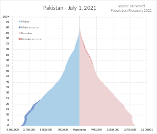
Pakistan had a population of 241,495,112 according to the final results of the 2023 Census. This figure includes Pakistan's four provinces e.g. Punjab, Sindh, KPK, Balochistan and Islamabad Capital Territory. AJK and Gilgit-Baltistan's census data is yet to be approved by CCI Council of Pakistan. Pakistan is the world's fifth most populous country.

The administrative units of Pakistan comprise four provinces, one federal territory, and two disputed territories: the provinces of Punjab, Sindh, Khyber Pakhtunkhwa, and Balochistan; the Islamabad Capital Territory; and the administrative territories of Azad Jammu and Kashmir and Gilgit–Baltistan. As part of the Kashmir conflict with neighbouring India, Pakistan has also claimed sovereignty over the Indian-controlled territories of Jammu and Kashmir and Ladakh since the First Kashmir War of 1947–1948. It also has a territorial dispute with India over Junagadh, but has never exercised administrative authority over either regions. All of Pakistan's provinces and territories are subdivided into divisions, which are further subdivided into districts, and then tehsils, which are again further subdivided into union councils.

Gilgit is a city in Pakistani-administered Gilgit–Baltistan in the disputed Kashmir region. It is the capital of the Gilgit-Baltistan region. The city is located in a broad valley near the confluence of the Gilgit and the Hunza rivers. It is a major tourist destination in Pakistan, serving as a hub for trekking and mountaineering expeditions in the Karakoram mountain range.

The districts of Pakistan are the third-level administrative divisions of Pakistan, below provinces and divisions, but forming the first-tier of local government. In total, there are 166 districts in Pakistan, including the Capital Territory, and the districts of Azad Kashmir and Gilgit-Baltistan. These districts are further divided into tehsils and union councils.

Hunza River is the principal river within the Hunza region in Gilgit–Baltistan, Pakistan. It is formed by the confluence of the Chapursan and Khunjerab nalas (gorges) which are fed by glaciers. It is also joined by the Gilgit River and the Naltar River, before it flows into the Indus River.
Balawaristan, is a term coined by Nawaz Khan Naji, founder of the Pakistani political party Balawaristan National Front (BNF), for a proposed autonomous province or a sovereign state consisting of Gilgit-Baltistan, Chitral and Kohistan regions in Pakistan as well as Indian-controlled Ladakh. Although the name, first used in 1989, does not have any historical basis, it sounds similar to Baloristan, which has been documented in Chinese sources to describe Baltistan and Gilgit Valley from the 8th century CE.

Gilgit Airport is a small domestic airport situated 1.25 nm (2.3 km) east of Gilgit, a city in the Gilgit-Baltistan territory of Pakistan. The city of Gilgit is one of the two major hubs for mountaineering expeditions in the northern areas of Pakistan.
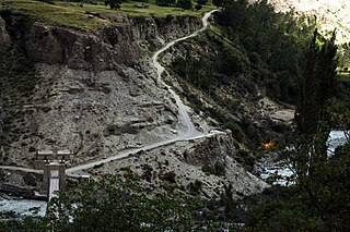
Bagrot Valley is a valley in the Karakoram range in the Gilgit-Baltistan region of northern Pakistan. River Bagrot flows through the valley from the north to the southwest, supplying water to the settlements of Jalalabad and Oshikhandass before merging with the Gilgit River.

Chaudhry Muhammad Barjees Tahir is a Pakistani politician who had been a member of the National Assembly of Pakistan from August 2018 till August 2023. Previously, he was a member of the National Assembly between 1990 and May 2018.

Gilgit-Baltistan, formerly known as the Northern Areas, is a region administered by Pakistan as an administrative territory and consists of the northern portion of the larger Kashmir region, which has been the subject of a dispute between India and Pakistan since 1947 and between India and China since 1959. It borders Azad Kashmir to the south, the province of Khyber Pakhtunkhwa to the west, the Wakhan Corridor of Afghanistan to the north, the Xinjiang region of China to the east and northeast, and the Indian-administered union territories of Jammu and Kashmir and Ladakh to the southeast.
The Special Communications Organization (SCO) (Urdu: خصوصی مواصلاتی تنظیم) is Pakistani public sector organization operated by MoIT&T. SCO plays a role in providing telecommunication services in Azad Kashmir and Gilgit Baltistan to almost 1.7 million people, a quarter of the total population. It operates its digital financial services under the brand name S-Paisa.

Mughal Minar is an archaeological site in Gilgit, Gilgit-Baltistan, Pakistan. It previously served as a Stupa.

Kargah Buddha is an archaeological site located about 6 miles (9.7 km) outside of Gilgit, Gilgit−Baltistan, Pakistan. It is a carved image of a large standing Buddha, some 50 ft (15 m) high, in the cliff-face in Kargah Nala. The carving, which is in a style also found in Baltistan, is estimated to date back to the 7th century.

Keno Daas (rock carvings) is an archaeological site in Gilgit, Gilgit-Baltistan, Pakistan. These are the important rock carvings, and are located just outside Gilgit, towards Hunza Valley.
Danyor Rock Inscriptions is an archaeological site in Danyor, Gilgit-Baltistan. It is a gigantic boulder bearing inscriptions from the 7th and 8th centuries A.D.

The Gilgit−Baltistan Scouts, are a federal paramilitary force in Pakistan, tasked with law enforcement in the nominally autonomous territory of Gilgit-Baltistan and border guard duties. The force was formed in 2003 under the control of the Interior Ministry of Pakistan, but it claims a tradition dating back to the Gilgit Scouts formed during the British Raj era. However, the earlier Scouts unit is now a full infantry regiment of the Pakistan Army (see Northern Light Infantry Regiment, which mostly operates in the same region as the current Scouts.
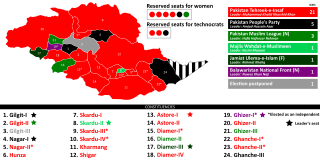
The 2020 Gilgit-Baltistan Assembly elections were held on 15 November 2020. Elections were held in 24 constituencies, each electing one member to the 3rd Gilgit-Baltistan Legislative Assembly. 330 candidates contested these elections, either representing one of the political parties of Gilgit-Baltistan or being an independent candidate.

The Bono-na or Bono nah is an ancient festival of the Minaro ( Brokpa) people hosted alternatively between Dha and Garkon villages of the Aryan Valley region of Ladakh, India with a gap of a year. It is a festival of thanksgiving to their deities and gods for good crops and prosperity to the people and the land of Minaro.
References
- ↑ "Sustainable Tourism and Cultural Heritage" (PDF). Bakhtiar Ahmed. IUCN, Northern Areas Programme. Archived from the original (PDF) on July 14, 2014. Retrieved July 5, 2014.
| | This Pakistan location article is a stub. You can help Wikipedia by expanding it. |
| | This article relating to archaeology in Asia is a stub. You can help Wikipedia by expanding it. |
| | This Gilgit-Baltistan history article is a stub. You can help Wikipedia by expanding it. |