Related Research Articles

The Town of Ignacio is a Statutory Town in La Plata County, Colorado, United States. The population was 697 at the 2010 United States Census. It is the headquarters of the Southern Ute Indian Reservation.

South Mahoning Township is a township in Indiana County, Pennsylvania, United States. The population was 1,841 at the 2010 census. Historic communities in the township include Ambrose, Denton, Elkin, Frantz, McCormick, Rossmoyne and Wells. The township surrounds Plumville, a separately incorporated borough.

Painter is a town in Accomack County, Virginia, United States. The population was recorded at 229 at the 2010 census.

The Shire of Baw Baw is a local government area in Victoria, Australia, in the eastern part of the state. It covers an area of 4,028 square kilometres (1,555 sq mi) and in June 2018 had a population of 52,015.

Murang'a County is one of the counties of Kenya's former Central Province. Its largest town and capital is Murang'a, formerly referred to as Fort Hall during the colonial era. It is inhabited mainly by and is considered the home of the Gikuyu, the largest ethnic group in Kenya. The county has a population of 1,056,640.

Lodwar is the largest town in north-western Kenya, located west of Lake Turkana on the A1 road. Its main industries are basket weaving and tourism. The Loima Hills lie to its west. Lodwar is the capital of Turkana County. The town has a population of 82,970 in 2019.

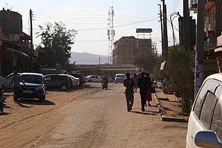
Murang'a is a town in Murang'a County of Kenya. Before the independence of Kenya in 1963, this town used to be called Fort Hall. It is the administrative centre of Murang'a County and is mainly inhabited by the Kikuyu community. According to the 1999 census, the town has a population of about 11,021.

Çatalpınar is a town and district of Ordu Province in the Black Sea region of Turkey, 56 km from the city of Ordu and 20 km from the town of Fatsa. According to the 2000 census, population of the district is 23,192 of which 10,265 live in the town of Çatalpınar. The district covers an area of 47 km2 (18 sq mi), and the town lies at an elevation of 22 m (72 ft).

Local authorities in Kenya are the bodies controlling local governance in urban areas in Kenya.
Maragua District was a former district of Kenya, located in the defunct Central Province. Its capital was the town of Maragua. In 1999, Maragua District had a population of 387,969 and an area of 868 km2. Maragua district was created in September 1996, when it was split from Muranga District.
The Esk'etemc First Nation, also known as the Alkali Lake Indian Band, is a First Nations government of the Secwepemc (Shuswap) people, located at Alkali Lake in the Cariboo region of the Central Interior of the Canadian province of British Columbia. It was created when the government of the then-Colony of British Columbia established an Indian reserve system in the 1860s. It is one of three Secwepemc bands that is not a member of either the Shuswap Nation Tribal Council or the Northern Shuswap Tribal Council.
Kigumo is a village in Muranga County, Kenya.
Wote is a town in Kenya. It is the capital of Makueni County in the former Eastern Province. It forms a town council with a population of 56,419, of whom 5,542 are classified urban.
Kandara is a town in Muranga County, Kenya. Kandara is located 10 kilometres south of Kigumo and 30 kilometres north of Thika. Kandara hosts a town council with a population of 28,840.
Konza is a small town in Machakos County, Kenya. It is located 70 kilometres (43 mi) south-east of Nairobi, the Kenyan capital. Machakos town, the county capital, is located 35 kilometres northeast of Konza.
Bandheri Ritesh खराड़ी सिंगर is a town in Dhar district of Madhya Pradesh, India.

The Figuig Province is a province in the Oriental Region of Morocco. Its capital is Bouarfa. It recorded a population of 138,325 in the 2014 Moroccan census, up from 129,430 in 2004.
The Taku River Tlingit First Nation are the band government of the Inland Tlingit in far northern British Columbia, Canada and also in Yukon. They comprise two ḵwaan (tribes) of the Tlingit people, who are otherwise coastal, the Áa Tlein Ḵwáan of the Atlin Lake area and the Deisleen Ḵwáan of Teslin Lake, whose main focus is the Teslin Tlingit Council in Teslin, Yukon. Their band offices are in Atlin, British Columbia.
Moi's Bridge is a small town that has its roots both in Uasin Gishu County, Trans Nzoia County and Kakamega County, Kenya. It is a town that has since grown as an agricultural center with the third largest NCPB in East Africa. Moi's Bridge is an electoral ward of the Soy Constituency and Uasin Gishu County. It is an important Kenyan area, often named as the 'bread basket' of Kenya. Moi's Bridge is also a location in the Soy division of Uasin Gishu District.
Sub-counties are the decentralised units through which county governments of Kenya will provide functions and services. Except for the parts which fall under urban areas, sub-counties will coincide with the constituencies created under article 89 of the Constitution of Kenya. Sub-counties will be headed by a sub-county administrator, appointed by a County Public Service Board.
References
- ↑ 1999 census [ permanent dead link ]
Coordinates: 0°47′0″S37°7′0″E / 0.78333°S 37.11667°E
| | This Kenya location article is a stub. You can help Wikipedia by expanding it. |