Abyar (al-Abyā) is a town in the Marj District, Libya, roughly 50 km to the east of the city of Benghazi and 42 km southwest of the city of Marj., its estimated population was 32,563.
Al Hiri is a town in the Al Wahat District in the Cyrenaica region of northeastern Libya. From 2001 to 2007 it was part of Ajdabiya District. Formerly (1983-1987) it was part of the Jalu District (baladiyah).
Shawashina is a desert town in the Al Wahat District in the Cyrenaica region of northeastern Libya.
Zuwetina is a coastal town and oil-exporting port in the Al Wahat District of the Cyrenaica region in north-eastern Libya. From 1987 to 2007 Zuwetina was in the former Ajdabiya District. The oil terminal in the small harbor is operated by the Zuwetina Oil Company. The town's primary activities relate to oil production and transshipping crude oil. It is about 180 km south west of Benghazi. The port was the site of skirmishes between pro- and anti-Gaddafi forces during the 2011 Libyan civil war.
Jikharra is a desert oasis town in the Al Wahat District, Cyrenaica region, in north-eastern Libya. Prior to 2007, it was in the Ajdabiya District.
Marada is a desert oasis in the Al Wahat District, Cyrenaica region, in northeastern Libya.
Masliwa is a Sahara desert town in the Al Wahat District in the Cyrenaica region of northeastern Libya.
Ahqaf al Jabbarat is a village in the District of Jebel el-Akhdar in north-eastern Cyrenaica, Libya. Ahqaf al Jabbarat is located about 21 km southwest of the city of Beida.

Haniya, or Al Haniyah, is a town in the District of Jebel el-Akhdar in north-eastern Libya.
Ahqaf al Ruzat is a village in the District of Jebel el-Akhdar in north-eastern Libya. Ahqaf al Ruzat is located about 23 km northeast of the city of Beida.
Safsaf is a town in the District of Jabal al Akhdar in north-eastern Libya. It is located about 16 km east of Bayda.
Zawiat at-Taban, or Taban ; also An-Nayan or Wadi Sammalus, is a check point in the District of Jabal al Akhdar in north-eastern Libya. It is located on the cross-roads between the Charruba–Mechili–Timimi desert road and the Marawa–Wadi Sammalus.

Qaryat ‘Umar al Mukhtar is a village in the District of Jabal al Akhdar in north-eastern Libya. It was named after the Libyan resistance leader Omar Mukhtar. Under the Italian rule it was known as Mameli after the Italian patriot Goffredo Mameli.
Khadra' is a village in the District of Jabal al Akhdar in north-eastern Libya. It is located 35 km south of Bayda.
Massa is a town in the District of Jebel el-Akhdar in north-eastern Libya. It is located 10 km west of Beida. During Italian rule, the town was known as Luigi Razza, probably after the late Italian politician of the same name.
Shahhat is a town in the District of Jabal al Akhdar in north-eastern Libya. Cyrene was located in the same area in ancient times. It is located 24 kilometres (15 mi) east of Bayda.
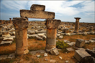
Susa or Soussa is a town and seaside resort in the District of Jabal al Akhdar in north-eastern Libya. Susa stands by the ruins of Apollonia, Cyrenaica. The town contains the Apollonia Museum. It is located about 30 km northeast of Bayda.
Qatrun, Al Katrun, Gatrone, or Al Gatrun is a village in the Murzuq District in southern Libya on the main road to Chad and Niger. It has a filling station and a Niger consulate office is located there. When the border checkpoint 310 kilometres south at Tumu is closed, travelers crossing into Libya from Niger report in at Qatrun.
Tajarhi, Tegerhi or Tajirhi is an oasis and crossroads village in the Murzuq District of Libya. It lies in the Sahara Desert and is the last refueling point in Libya before reaching Madama, the first station in Niger, some 282 kilometers to the south, or 361 km by track. Tajarhi has an airstrip (HL-57) south of town.
ʿAyn al Ghazaya is a village in Nalut District in northwestern Libya. It lies on a crossroads on the Wazzin–Nalut road on the northern edge of the Tripolitanian Plateau in the Nafusa Mountains.