
DeTour Village is a village in Chippewa County in the U.S. state of Michigan. The population was 325 at the 2010 census.

Conover is a town in Vilas County, Wisconsin, United States. The population was 1,235 at the 2010 census. The unincorporated community of Conover is located in the town.
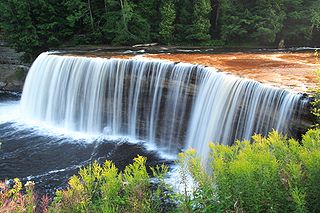
The Tahquamenon Falls are two different waterfalls on the Tahquamenon River. Both sets are located near Lake Superior in the eastern Upper Peninsula of Michigan. The water is notably brown in color from the tannins leached from the cedar swamps which the river drains. The upper falls are more than 200 feet across and with a drop of approximately 48 feet During the late spring runoff, the river drains as much as 50,000 US gallons (190,000 L) of water per second, making the upper falls the third most voluminous vertical waterfall east of the Mississippi River, after Niagara Falls and Cohoes Falls, both in New York State.

Cascade Mountain is in Essex County of New York. It is one of the 46 Adirondack High Peaks (36th) and is located in the Adirondack Park. Its name comes from a series of waterfalls on a brook near the mountain's base. The lake it flows into and the pass between Cascade and Pitchoff mountains are also named Cascade.

The Snowbank Trail is a hiking trail in the Boundary Waters Canoe Area Wilderness (BWCAW) in northern Minnesota. The trail runs the perimeter of Snowbank Lake and crosses the Kekekabic Trail at the south side of Snowbank Lake. The entire trail comprises a 24-mile (39 km) loop, numerous campsites are available. During the BWCAW Visitor' Distribution Program, permits are required for overnight use of the trail. It is located in Fall Lake Township in northernmost Lake County.
The Mantario Trail is a multipurpose trail in southeastern Manitoba. It is 63 kilometers long and meanders through rugged Canadian Shield. Most of the trail is located within Whiteshell Provincial Park, although it enters Ontario. It is named after Mantario Lake, where one of several campsites that are along the trail sits. A large portion of the Mantario Trail is in a Wilderness Zone which is an area protected from motorized access and hunting.

The Bullhead Trail is an American hiking trail in the Great Smoky Mountains National Park, in Sevier County, Tennessee. The trail ascends Mount Le Conte, the tallest mountain east of the Mississippi River and offers outstanding views before joining the Rainbow Falls Trail before terminating near the LeConte Lodge.

The Boulevard Trail is an American hiking trail in the Great Smoky Mountains National Park, in Sevier County, Tennessee. The trail ascends Mount Le Conte, the tallest mountain east of the Mississippi River and offers high-elevation views before terminating near the LeConte Lodge.
The Bill Hall Trail is a hiking trail in Grand Canyon National Park, located in the U.S. state of Arizona.
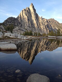
The Enchantments is an area comprising an upper and a lower basin, the lakes and tarns contained within them, and the peaks of the Stuart Range bounding the basins. The area is located entirely within the Alpine Lakes Wilderness about 15 miles (24 km) southwest of Leavenworth, Washington in the United States. The Enchantments is regarded as one of the most spectacular locations in the Cascade Range.

The Foothills Trail is a 76-mile (122 km) National Recreation Trail in South and North Carolina, United States, for recreational hiking and backpacking. It extends from Table Rock State Park to Oconee State Park. It passes through the Andrew Pickens Ranger District of the Sumter National Forest, Ellicott Rock Wilderness, Whitewater Falls, and Lake Jocassee.

Buntzen Lake is a 4.8 kilometres (3 mi) long lake in Anmore, British Columbia, Canada, in the Greater Vancouver area. It is named after the first general manager of the B.C. Electric Co., Johannes Buntzen. There is a smaller lake just to the north named McCombe Lake.

The Columbia Plateau Trail is a 130-mile-long (210 km), 20-foot-wide (6.1 m) corridor in eastern Washington state maintained as part of the Washington State Park system. The trail runs along the abandoned right-of-way of the former Spokane, Portland and Seattle Railway from Cheney to the confluence of the Snake and Columbia rivers at Pasco, Washington, passing through five counties in the southeastern part of the state. The trail's recreational uses include hiking, mountain biking, horseback riding, in-line skating on paved portions, and wildlife viewing.

The Maddron Bald Trail is an American hiking trail in the Great Smoky Mountains National Park of Cocke County, Tennessee. Rising from the outskirts of the Cosby community, the trail ascends Maddron Bald, a 5,212-foot (1,589 m) mountain crowned by one of the park's most substantial heath balds. The trail also provides access to Albright Grove, a patch of old growth hardwood forest that contains some of the oldest and tallest trees in the Smokies. The Maddron Bald Trail's terminus— at its junction with the Snake Den Ridge Trail— is just 0.7 miles (1.1 km) from the Appalachian Trail.
Millcreek Canyon is a canyon in the Wasatch Mountains and part of Millcreek City on the east side of the Salt Lake Valley, Utah. It is a popular recreation area both in the summer and in the winter. It was named after all the mills that were once located in the densely forested canyon. It is home to two restaurants and six Boy Scout Day Camps.
Horseshoe Bay Trail is a 6.4-mile (10.3 km) trail that enters and loops through the Horseshoe Bay Wilderness. The motor-vehicle trailhead, located just outside the wilderness, is 6 miles (9.7 km) north of St. Ignace, MI.

Mount Ellinor is a peak in the Olympic Mountains of Washington, United States. It is located in an area designated as the Mount Skokomish Wilderness. The mountain is a popular day hike in the summer months, being that the summit is reachable via a steep-but-brief 3.3-mile (5.3 km) trail which gains about 3,200 feet (980 m) in elevation from the lower of two trailheads. Mountain goats are frequently observable along this trail, but it is advisable to keep a safe distance from them. The trailhead is accessible from National Forest Road 24 north of Lake Cushman. This lower trailhead lies at an elevation of 2,600 feet (790 m). A Northwest Forest Pass or appropriate parking permit is required at the upper trailhead, which starts at 3,500 feet.
The Chatfield Trail is a 4.7-mile Blue-Blazed hiking trail located within the town of Killingworth, Connecticut.


