Ogemaw Hills Pathway

Last updated
Ogemaw Hills Pathway
Ogemaw Hills Pathway (August 2021).jpg
Fairview Road entrance within Klacking Township
USA Michigan location map.svg
Red pog.svg
Location within the state of Michigan
LocationLower Peninsula, Ogemaw County, Michigan USA
Nearest city West Branch, Michigan
Coordinates 44°21′02″N84°13′33″W / 44.350430°N 84.225906°W / 44.350430; -84.225906
Governing body Michigan Department of Natural Resources
Website Official website
Ogemaw Hills Pathway trailhead Ogemaw Hills Pathway trailhead (August 2021).jpg
Ogemaw Hills Pathway trailhead

Ogemaw Hills Pathway is a foot-travel pathway located north of West Branch, Michigan within the Au Sable State Forest in Ogemaw County, Michigan. The Pathway offers approximately 15 miles of trails open to hiking, cross country skiing, and biking. The Ogemaw Hills Pathway Council non-profit [1] manages the trail system and grooms the trails for cross country skiing. [2]

Contents

Ogemaw Hills Pathway foot-travel pathway designation bans all motorized vehicle travel and equine use of the trail system.

Geography

The Ogemaw Hills Pathway trail system traverses a well defined ridge of hills north of West Branch, Michigan referred to by geologists as the West Branch Moraine, a recessional moraine outwash formed by the Saginaw Lobe of the Laurentide Ice Sheet. [3] The West Branch Moraine marks a northern border of the Pleistocene proglacial Lake Saginaw that formed in front of the melting Saginaw Lobe and retreated into present day Saginaw Bay. [3]

History

Ogemaw State Forest was administratively created in 1914 under the leadership of Michigan State Forester Marcus Schaaf [4] and consisted of 4,160 acres (1,680 ha). A fifty-foot steel fire lookout tower was constructed in the fall of 1914 and the footings are still visible. Grover Zettle was named superintendent of the Ogemaw State Forest in 1914. [5]

Pioneer farmers found the glacial outwash sandy soil poor for farming and many farms were abandoned, reverting to state ownership for non-payment of taxes. Many clearings within the Ogemaw Hills Pathway trail system are old farm fields being reclaimed by the forest and fence lines, rock piles, and foundations can be found.

In 1978 the fifty three state forests were consolidated into six forest Districts and the Ogemaw State Forest became part of the Au Sable State Forest.

Trail System

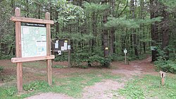
The trail system features a well defined trail-tread and is blazed by blue triangle markers. The trail system features 26 intersection posts consisting of location number, a trail map, direction of travel arrows, and trail difficulty markers from easiest to most difficult of green circle, blue square, and black diamonds.

Related Research Articles

<span class="mw-page-title-main">Au Sable River (Michigan)</span> River in Michigan, United States

The Au Sable River in Michigan, United States runs approximately 138 miles (222 km) through the northern Lower Peninsula, through the towns of Grayling and Mio, and enters Lake Huron at the town of Oscoda. It is considered one of the best brown trout fisheries east of the Rockies and has been designated a blue ribbon trout stream by the Michigan Department of Natural Resources. A map from 1795 located in the United States Gazetteer calls it the Beauais River. In French, the river is called the Rivière au sable, literally "Sand River".

<span class="mw-page-title-main">Roscommon County, Michigan</span> County in Michigan, United States

Roscommon County is a county located in the U.S. state of Michigan. As of the 2020 Census, the population was 23,459. The county seat is Roscommon. The county was founded in 1840 and organized in 1875.

<span class="mw-page-title-main">Oscoda County, Michigan</span> County in Michigan, United States

Oscoda County is a county in the U.S. state of Michigan. As of the 2020 census, the population was 8,219, making it the least populous county in the Lower Peninsula, and the sixth-least populous county in the entire state. The county seat is Mio, an unincorporated community near the center of the county.

<span class="mw-page-title-main">Crawford County, Michigan</span> County in Michigan, United States

Crawford County is a county in the U.S. state of Michigan. Its population was 12,988 as of the 2020 census. The county seat of Crawford County is Grayling, the county's only incorporated community.

<span class="mw-page-title-main">Grayling, Michigan</span> City in Michigan, United States

Grayling is a city and the county seat of Crawford County in the U.S. state of Michigan. It is the only incorporated community in Crawford County. The population was 1,884 at the 2010 census. The city is surrounded by Grayling Charter Township, but the two are administered autonomously.

<span class="mw-page-title-main">Huron–Manistee National Forests</span> National forest in Michigan, United States

The Huron–Manistee National Forests are two separate national forests, the Huron National Forest and the Manistee National Forest, combined in 1945 for administration purposes and which comprise 978,906 acres (3,960 km2) of public lands, including 5,786 acres (23 km2) of wetlands, extending across the northern lower peninsula of Michigan. The Huron–Manistee National Forests provide recreation opportunities for visitors, habitat for fish and wildlife, and resources for local industry. The headquarters for the forests is in Cadillac, Michigan.

<span class="mw-page-title-main">Manistee National Forest</span> National forest

The Manistee National Forest is a national forest located in the Lower Peninsula of Michigan. It has a total area of 540,187 acres (2,190 km2). It was established in 1938, and combined with the Huron National Forest in 1945 for administrative purposes, creating the Huron-Manistee National Forests. However, they are two separate forest units, as they are not connected. The area is popular for hiking, fishing, camping, boating, snowmobiling, cross-country skiing and hunting. The North Country Trail passes through it, and connects with the 11-mile Manistee River Trail to form a 23-mile loop. The highest point in the lower peninsula, Briar Hill (1,706 ft), is located here. The Manistee National Forest is not one continuous mass, but is a "mosaic" broken by private property and towns. The headquarters for the forest is in Cadillac, Michigan.

<span class="mw-page-title-main">Kettle Moraine</span>

Kettle Moraine is a large moraine in the state of Wisconsin, United States. It stretches from Walworth County in the south to Kewaunee County in the north. It has also been referred to as the Kettle Range and, in geological texts, as the Kettle Interlobate Moraine.

<span class="mw-page-title-main">Au Sable State Forest</span> State forest on the Lower Peninsula of Michigan, US

The Au Sable State Forest is a state forest in the north-central Lower Peninsula of Michigan. It is operated by the Michigan Department of Natural Resources.

<span class="mw-page-title-main">Fairview, Michigan</span> Unincorporated community in Michigan, United States

Fairview is an unincorporated community in Oscoda County in the U.S. state of Michigan. It is located within Comins Township at the intersection of highways M-33 and M-72 at 44°43′30″N84°03′04″W.

<span class="mw-page-title-main">Valparaiso Moraine</span> Moraine in the midwestern United States

The Valparaiso Moraine is a recessional moraine that forms an immense U around the southern Lake Michigan basin in North America. It is the longest moraine. It is a band of hilly terrain composed of glacial till and sand. The Valparaiso Moraine forms part of the Saint Lawrence River Divide, bounding the Great Lakes Basin. It begins near the border of Wisconsin and Illinois and extends south through Lake, McHenry, Cook, DuPage and Will counties in Illinois, and then turns southeast, going through northwestern Indiana. From this point, the moraine curves northeast through Lake, Porter, and LaPorte counties of Indiana into Michigan. It continues into Michigan as far as Montcalm County.

<span class="mw-page-title-main">Kankakee Outwash Plain</span>

The Kankakee Outwash Plain is a flat plain interspersed with sand dunes in the Kankakee River valley in northwestern Indiana and northeastern Illinois of the United States. It is just south of the Valparaiso Moraine and was formed during the Wisconsin Glaciation. As the glacier stopped at the Valparaiso Moraine, its meltwater was carried away to the outwash plain. On the south side of the moraine, where the elevation drops, the meltwaters eroded away valleys, carrying sand and mud with them. As the muddy meltwater reached the valley where the slope lessened, the water slowed, depositing the sand on the outwash plain. This created a smooth, flat, and sandy plain. Before its draining, the Kankakee Marsh, located on the outwash plain, was one of the largest freshwater marshes in the United States.

<span class="mw-page-title-main">Rifle River State Recreation Area</span> State park in Michigan, United States

Rifle River State Recreation Area is a state park located on the upper reaches of the Rifle River within the Au Sable State Forest in Ogemaw County in the U.S. state of Michigan. Covering 4,449 acres (1,800 ha), the area provides a variety of recreational opportunities, including boating, canoeing, hiking, hunting, fishing, cross-country skiing, biking, and swimming.

<span class="mw-page-title-main">Kankakee Torrent</span>

The Kankakee Torrent was a catastrophic flood that occurred about 19,000 calibrated years ago in the Midwestern United States. It resulted from a breach of moraines forming a large glacial lake fed by the melting of the Late Wisconsin Laurentide Ice Sheet. The point of origin of the flood was Lake Chicago. The landscape south of Chicago still shows the effects of the torrent, particularly at Kankakee River State Park and on the Illinois River at Starved Rock State Park.

The Mississinawa Moraine begins in Ohio east of Lima in Hardin County, then running in a shallow arc to the south of Grand Lake St. Marys and St. Marys in Mercer County towards Fort Recovery, Ohio. Just west of Fort Recovery, the moraine again arches southward towards the Mississinewa River. The moraine follows the eastern bank of the river northwestward to where it enters the Wabash River at Wabash, Indiana. Angling towards the north and a little east, the Mississinawa moraine merges with the Packerton Moraine north of the Eel River in Whitley County near Columbia City. The moraine does not end here, but continues in a northeasterly direction through the three corners area of Michigan, Indiana, and Ohio until reaching Ann Arbor, Michigan where numerous moraines intermingle. Note: There are two common spellings of the name. Mississinawa is commonly used in the older reports. Mississinewa is the modern usage and the spelling used on modern maps and projects associated with the river. Both spellings are used interchangeably in this article, based on the source material.

<span class="mw-page-title-main">Lake Kankakee</span>

Lake Kankakee formed 14,000 years before present (YBP) in the valley of the Kankakee River. It developed from the outwash of the Michigan Lobe, Saginaw Lobe, and the Huron-Erie Lobe of the Wisconsin glaciation. These three ice sheets formed a basin across Northwestern Indiana. It was a time when the glaciers were receding, but had stopped for a thousand years in these locations. The lake drained about 13,000 YBP, until reaching the level of the Momence Ledge. The outcropping of limestone created an artificial base level, holding water throughout the upper basin, creating the Grand Kankakee Marsh.

<span class="mw-page-title-main">Marseilles moraine</span>

The Marseilles moraine is a terminal moraine that encircles the southern tip of Lake Michigan in North America. It begins near Elgin, Illinois, and extends south and west of Chicago metropolitan area, turning eastward 30 miles (48 km) to 40 miles (64 km) south of the lake in Kankakee and Iroqouis counties, entering Indiana. It formed during the Wisconsin glaciation. The glacier had been in retreat when it stopped for an extended period, depositing glacial till and sand creating the hills of the moraine.

<span class="mw-page-title-main">Lake Saginaw</span> Former lake in North America

Lake Saginaw occupied the basin of Saginaw Bay. There were two periods when it was an independent lake, not associated with a larger body of water in the Huron basin. The first Lake Saginaw was a contemporary of the last stages of Lake Maumee. When the ice border opened allowing these two lakes to become one, it entered the period of Lake Arkona. Then, the ice advanced, closing the link forming the second Lake Saginaw. This was during the time of Lake Whittlesey. When the ice margin retreated northward for the last time, it became the western bay of Lake Wayne and then of Lake Warren and Lake Lundy. During its periods as an independent lake, its outlet was west through Grand River channel.

<span class="mw-page-title-main">Lake Border Moraine</span>

The Lake Border Moraine is a complex group of moraines bordering the southern end of Lake Michigan. It can be traced north along the eastern shore of the lake basin and across the highlands between the northern Lake Michigan and Saginaw Bay. It continues around the Saginaw Basin into the "thumb" of Michigan, and south through southeastern Michigan on the eastern side of the "thumb." Along Lake Michigan, north to Holland the system is close to the shore. From Holland north to Oceana County it is 15 miles (24 km) to 25 miles (40 km) east of the shore. In Oceana County it forms the prominent "clay banks" along the shoreline of Lake Michigan. It again bears inland from Hart, where more recent moraines reside between it and Lake Michigan. It runs north of the great interlobate moraine that exists between the Lake Michigan and Saginaw lobes of the Laurentian ice sheet. A little north of Cadillac turns to the east. A short distance from Cadillac, it splits with the southern ridge or outer member heading to the Saginaw basin. The northern ridge heads towards Lake Huron, but turns south before reaching the shore. In Newaygo and Lake counties it rest on an earlier interlobate moraine. It separates in Wexford and Missaukee counties to continue south along the west side of the Saginaw basin.

<span class="mw-page-title-main">Packerton Moraine</span> Moraine in Indiana

The Packerton Moraine in north-central Indiana has been considered by most persons who have studied it to be a large interlobate moraine between the Saginaw and the Erie lobes. The northeast-southwest direction of the eskers north of Disko, Wabash County, and the southeast-northwest trend south of there indicated that the part of the Packerton moraine south of Disko was built by the Erie lobe and the part north of Disko by the Saginaw lobe. An esker, Miami County shows a northeast-southwest alignment, providing evidence that Packerton moraine in Miami County was built by the Erie lobe. A small area in the northwestern was deposited by the Saginaw lobe. It is named the Packerton moraine from the village of Packerton in Kosciusko County. Thirteen kames and eskers complexes are mixed with sand and gravel. The till is, sandier, especially in the part deposited by the Saginaw lobe, than in the lobe passed over some source of sand, whereas the Erie lobe did not. Water-laid or wind-blown sands are found throughout the moraine. The bulk of the sand seems to have been water-deposited, but locally the sand appears to have been reworked by the wind. Few of the sand deposits exhibit dunal forms.

References

  1. "Cross country ski event to benefit Ogemaw Hills Pathway". The Ogemaw County Herald. 12 February 2014. Retrieved 26 February 2017.
  2. Semion, Bill (30 December 2011). "Enjoy a quiet trail: Four hidden gems to cross-country ski in Michigan". The Grand Rapids Press. Retrieved 26 February 2017.
  3. 1 2 Schaetzl, Randall. "Major Glacial Ice Lobes". GEO 333: Geography of Michigan and the Great Lakes Region. Michigan State University. Retrieved 26 February 2017.
  4. Moore, Mike. "A Short History of the Michigan State Forests: The Early Days". Michigan Forests Forever Teacher's Guide. Michigan Forests Forever. Retrieved 26 February 2017.
  5. "Ogemaw State Forest turns 100 with rededication ceremony". The Ogemaw County Herald. 21 August 2014. Retrieved 26 February 2017.