Mariahout

Last updated
Mariahout

Mariahout - Mariastraat 25 - OLV van Lourdes kerk.jpg

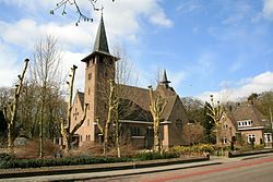
The Our Lady of Lourdes Church in Mariahout
Coordinates: 51°32′20″N5°34′2″E / 51.53889°N 5.56722°E / 51.53889; 5.56722
Country Netherlands
Province North Brabant
Municipality Laarbeek
Population (1 juni 2006) 1,626
Time zone CET (UTC+1)
  Summer (DST) CEST (UTC+2)
Postcode 5738
Area code 0499

Mariahout is a small village located in the province of North Brabant in the south of the Netherlands, about 20 kilometers northeast of Eindhoven. Mariahout has a population of about 1700 and is the smallest village of the municipality of Laarbeek.

North Brabant Province of the Netherlands

North Brabant, also unofficially called Brabant, is a province in the south of the Netherlands. It borders the provinces of South Holland and Gelderland to the north, Limburg to the east, Zeeland to the west, and Belgium to the south. The northern border follows the Meuse westward to its mouth in the Hollands Diep strait, part of the Rhine–Meuse–Scheldt delta.

Netherlands Constituent country of the Kingdom of the Netherlands in Europe

The Netherlands is a country located mainly in Northwestern Europe. The European portion of the Netherlands consists of twelve separate provinces that border Germany to the east, Belgium to the south, and the North Sea to the northwest, with maritime borders in the North Sea with Belgium, Germany and the United Kingdom. Together with three island territories in the Caribbean Sea—Bonaire, Sint Eustatius and Saba— it forms a constituent country of the Kingdom of the Netherlands. The official language is Dutch, but a secondary official language in the province of Friesland is West Frisian.

Eindhoven City and municipality in North Brabant, Netherlands

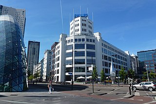
Eindhoven is the fifth-largest city and a municipality of the Netherlands, located in the south of the country. It had a population of 229,126 in 2018, making it the largest city in the province of North Brabant, although 's-Hertogenbosch is its capital. Eindhoven was originally located at the confluence of the Dommel and Gender.

Contents

History

From 1920 onwards, the heath land in the western part of the municipality of Lieshout was cultivated. Since then many new farmsteads were built that, together with an existing settlement, formed a new village community. This village was officially established in 1933 when it was given the name Mariahout. This name is a contraction of Maria, the patron saint of the new parish, and Lieshout. Until 1997 Mariahout was a part of the municipality of Lieshout. When this municipality was abolished on 1 January 1997, the village became part of the new municipality of Laarbeek. [1]

Lieshout Village and former municipality in North Brabant, Netherlands

Lieshout is a small village located in the province of North Brabant in the south of the Netherlands, about 15 kilometres northeast of Eindhoven. There are 4,300 inhabitants, and the village is known for its beer brewery called 'Bavaria'. The spoken language is Peellands.

Patron saint saint regarded as the tutelary spirit or heavenly advocate of a nation, place, craft, activity, class, clan, family, or person

A patron saint, patroness saint, patron hallow or heavenly protector is a saint who in Roman Catholicism, Anglicanism or Eastern Orthodoxy, is regarded as the heavenly advocate of a nation, place, craft, activity, class, clan, family or person.

Born in Mariahout

Guus Meeuwis Dutch singer

Gustaaf Stephanus Modestus "Guus" Meeuwis is a Dutch singe-songwriter. As part of the band Vagant, he scored several hits in the Netherlands and Flanders during the 1990s and first decade of the 2000s. On 24 May 2015, Meeuwis became the first Dutch language performing artist ever to play a fully booked concert at London's Royal Albert Hall.

Related Research Articles

Laarbeek Municipality in North Brabant, Netherlands

Laarbeek is a municipality located in the province of North Brabant in the south of the Netherlands. It was formed in 1997 from the former municipalities Beek en Donk, Aarle-Rixtel and Lieshout. Laarbeek is part of the city region 'Samenwerkingsverband Regio Eindhoven', centered on the city of Eindhoven. The town hall is located in Beek en Donk.

Wilsum is a village in the Dutch province of Overijssel. It is located in the municipality of Kampen, about 4 km southeast of that city.

Kamperveen is a small village in the Dutch province of Overijssel. It is located in the municipality of Kampen, about 5 km south of the city.

Geldrop Town and former municipality in North Brabant, Netherlands

Geldrop is a town in the Dutch province of North Brabant. It is located in the municipality of Geldrop-Mierlo.

Klundert City in North Brabant, Netherlands

Klundert is a city in the Dutch province of North Brabant. It is located close to the Hollands Diep, about 3 km northwest of Zevenbergen. It received city rights in 1357.

Aarle-Rixtel Village and former municipality in North Brabant, Netherlands

Aarle-Rixtel is a village in the Dutch municipality of Laarbeek in North Brabant. It lies about 4 km north of Helmond. Since the municipal reorganization of 1968 the castle Croy is part of Aarle-Rixtel.

Liempde is a village in the Netherlands in the municipality Boxtel. Annually the Flevo Christian music festival is held here. In 2005 the event What the Hack took place in Liempde.

Kesteren Place in Gelderland, Netherlands

Kesteren is a town in the Dutch province of Gelderland. It is a part of the municipality of Neder-Betuwe, and lies about 8 km southwest of Wageningen.

Mariekerke is a former municipality in the Dutch province of Zeeland. The municipality was formed in a merger of Aagtekerke, Grijpskerke and Meliskerke in 1966, and existed until 1997 when it merged into the municipality of Veere.

Sint Laurens Place in Zeeland, Netherlands

Sint Laurens is a village in the Dutch province of Zeeland. It is located in the municipality of Middelburg, about 3 km north of the city.

Wolphaartsdijk Place in Zeeland, Netherlands

Wolphaartsdijk is a village in the Netherlands, located in the province Zeeland. Wolphaartsdijk is part of the municipality of Goes. In 2009 the village had 2109 inhabitants.

Wanssum Dorp in Limburg, Netherlands

Wanssum is a village in the Dutch province of Limburg. It is located in the municipality of Venray.

Ginneken en Bavel was a municipality in the Dutch province of North Brabant, located southeast of the city of Breda. It covered the villages of Ginneken and Bavel.

Moergestel Place in North Brabant, Netherlands

Moergestel is a village in the Dutch province of North Brabant. It is located in the municipality of Oisterwijk, about 7 km East of Tilburg.

Nistelrode Place in North Brabant, Netherlands

Nistelrode is a small town in the Dutch province of North Brabant. It is located in the municipality of Bernheze, about 8 km south of Oss.

Bavel, Netherlands Dorp in North Brabant, Netherlands

Bavel is a village in the southern Netherlands. It is located in the Dutch province of North Brabant, largely within the municipality of Breda with some rural areas in the municipality of Alphen-Chaam.

Sint Anthoniepolder is a small village in the Dutch province of South Holland. It is located about 14 km south of the city of Rotterdam, in the municipality of Binnenmaas.

Heikant is a hamlet in the municipality of Laarbeek, in the Dutch province of North Brabant. It is located about 3 km east of Aarle-Rixtel.

Bozbinə Place in Zaqatala, Azerbaijan

Bozbinə is a village in the Zaqatala Rayon of Azerbaijan. The village forms part of the municipality of Dombabinə.

References

  1. Ad van der Meer, Onno Boonstra (2006), Repertorium van Nederlandse gemeenten 1812-2006, The Hague, DANS, ISBN   90 6984 495 8

Coordinates: 51°32′N5°34′E / 51.533°N 5.567°E / 51.533; 5.567

Geographic coordinate system Coordinate system

A geographic coordinate system is a coordinate system that enables every location on Earth to be specified by a set of numbers, letters or symbols. The coordinates are often chosen such that one of the numbers represents a vertical position and two or three of the numbers represent a horizontal position; alternatively, a geographic position may be expressed in a combined three-dimensional Cartesian vector. A common choice of coordinates is latitude, longitude and elevation. To specify a location on a plane requires a map projection.