Mariara

Last updated
Mariara
Mariarakirche.jpg
Bandera Municipio Diego Ibarra.png
Flag
Escudo Diego Ibarra Carabobo.PNG
Coat of arms
Venezuela location map (+claimed).svg
Red pog.svg
Mariara
Coordinates: 10°17′37″N67°42′40″W / 10.29361°N 67.71111°W / 10.29361; -67.71111 Coordinates: 10°17′37″N67°42′40″W / 10.29361°N 67.71111°W / 10.29361; -67.71111
Country Flag of Venezuela.svg  Venezuela
State Carabobo
Municipality Diego Ibarra Municipality
Founded3 December 1781
Elevation
454 m (1,490 ft)
Population
 (2010)
  Total115,515
   Demonym
Mariareño/a Mariarense
Time zone UTC−4 (VET)
Postal code
2017
Area code(s) 0243
Climate Aw

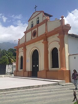
Mariara is a city in Carabobo State, Venezuela, the shire town of the Diego Ibarra Municipality. It was founded by bishop Mariano Marti on 3 December 1781.

Contents

History

Europeans found Carib tribes when they arrived to this region in the middle of the 16th century. Conquistador Vicente Díaz explored the area around 1555 and fought against some Native Americans around Mariara. [1]

During the Colony, the Tovar family had large plantations here. Bishop Mariano Martí founded Mariara officially on 3 December 1781. Alexander von Humboldt visited in 1800.

The Ayundamiento de Valencia was created in 1810, comprising nine regions: Valencia, Los Guayos, Puerto Cabello, Ocumare de la Costa, Turmero, Guacara, Güigüe, Maracay and Mariara.

Climate

Climate data for Mariara
MonthJanFebMarAprMayJunJulAugSepOctNovDecYear
Average high °C (°F)29.3
(84.7)
29.8
(85.6)
30.6
(87.1)
30.3
(86.5)
29.3
(84.7)
28.1
(82.6)
27.7
(81.9)
28.2
(82.8)
28.6
(83.5)
29.2
(84.6)
29.0
(84.2)
28.9
(84.0)
29.1
(84.4)
Daily mean °C (°F)22.7
(72.9)
23.1
(73.6)
24.0
(75.2)
24.7
(76.5)
24.6
(76.3)
23.7
(74.7)
23.3
(73.9)
23.4
(74.1)
23.6
(74.5)
23.8
(74.8)
23.5
(74.3)
22.9
(73.2)
23.6
(74.5)
Average low °C (°F)15.3
(59.5)
15.4
(59.7)
16.5
(61.7)
18.3
(64.9)
18.7
(65.7)
18.4
(65.1)
17.8
(64.0)
17.7
(63.9)
17.7
(63.9)
17.7
(63.9)
17.1
(62.8)
16.1
(61.0)
17.2
(63.0)
Average precipitation mm (inches)7.7
(0.30)
6.4
(0.25)
11.4
(0.45)
57.2
(2.25)
130.2
(5.13)
146.6
(5.77)
161.6
(6.36)
183.4
(7.22)
146.9
(5.78)
129.7
(5.11)
80.6
(3.17)
22.4
(0.88)
1,084.1
(42.68)
Average precipitation days3.11.91.96.912.616.917.919.216.014.611.76.2128.9
Average relative humidity (%)72.468.966.470.676.278.781.782.281.681.379.675.976.3
Source: [2]

Related Research Articles

Valencia, Carabobo Place in Carabobo, Venezuela

Valencia is the capital city of Carabobo State and the third-largest city in Venezuela.

Carabobo State of Venezuela

Carabobo State is one of the 23 states of Venezuela, located in the north of the country, about two hours by car from Caracas. The capital city of this state is Valencia, which is also the country's main industrial center. The state's area is 4,369 km2 (1,687 sq mi) and as of the 2011 census, had a population of 2,245,744.

Lake Valencia (Venezuela)

Lake Valencia, formerly Lake Tacarigua, is a lake within Carabobo State and Aragua State in northern Venezuela.

Valle de la Pascua Place in Guárico, Venezuela

Valle de la Pascua is the capital city of the autonomous municipality of Leonardo Infante, Guárico, Venezuela. The city is located in the central plains of Venezuela and was founded on February 25, 1785, by Father Mariano Martí. Along with Zaraza, Calabozo and San Juan de Los Morros, Valle de la Pascua is one of the most important cities in the state of Guárico and the most important economically. The vicinity of the city was the scene of the Battle of Valle de la Pascua in February 1814.

The Revolt of the Comuneros was a popular uprising in the Viceroyalty of New Granada against the Spanish authorities from March through October 1781. The revolt was in reaction to the increase in taxation to raise funds for defense of the region against the British, a rise in the price of tobacco and brandy, which were part of the late eighteenth-century Bourbon reforms. The initial revolt was local and not well known outside the region of Socorro, but in the late nineteenth century, historian Manuel Briceño saw the massive revolt as a precursor to independence. Prior to the 1781 revolt, residents in New Granada had protested, at times violently, crown policy implementation there between 1740 and 1779.

Caucagua Place in Miranda, Venezuela

Caucagua is a Venezuelan city in the state of Miranda, and is capital of the Acevedo Municipality.

Roman Catholic Diocese of Segorbe-Castellón Spanish diocese of the Catholic Church

The Diocese of Segorbe-Castellón is a Roman Catholic ecclesiastical territory located in north-eastern Spain, in the province of Castellón, part of the autonomous community of Valencia. The diocese forms part of the ecclesiastical province of Valencia, and is thus suffragan to the Archdiocese of Valencia.

Roman Catholic Archdiocese of Valencia in Spain

The Archdiocese of Valencia is a Catholic ecclesiastical territory located in north-eastern Spain, in the province of Valencia, part of the autonomous community of Valencia. The archdiocese heads the ecclesiastical province of Valencia, with authority over the suffragan dioceses of Ibiza, Majorca, Minorca, Orihuela-Alicante and Segorbe-Castellón. The archbishops are seated in Valencia Cathedral. On 28 August 2014, Pope Francis appointed Cardinal Antonio Cañizares Llovera as the next archbishop of Valencia.

Roman Catholic Archdiocese of Caracas

The Roman Catholic Archdiocese of Caracas is the Latin an ecclesiastical territory of the Roman Catholic Church in part of Venezuela. It was founded as the Diocese of Caracas on June 20, 1637, and was later elevated to the rank of a Metropolitan see on November 27, 1803.

Los Guayos Place

Los Guayos is a town in Carabobo State, Venezuela, northwest of the Valencia Lake. It is the capital of the Los Guayos Municipality and is part of Valencia's metropolitan area.

Los Guayos Municipality Municipality in Carabobo, Venezuela

The Los Guayos Municipality is one of the 14 municipalities (municipios) that makes up the Venezuelan state of Carabobo and, according to the 2011 census by the National Institute of Statistics of Venezuela, the municipality has a population of 149,646. The town of Los Guayos is the shire town of the Los Guayos Municipality.

Naguanagua Municipality Municipality in Carabobo, Venezuela

The Naguanagua municipality is one of the 14 municipalities (municipios) that makes up the Venezuelan state of Carabobo and, according to the 2011 census by the National Institute of Statistics of Venezuela, the municipality has a population of 157,437. The town of Naguanagua is the shire town of the Naguanagua Municipality. It forms part of the greater Valencia Metropolitan Area in Venezuela. It is in the valley of the Cabriales River at the base of Cerro El Café and the El Trigal Mountain. Valencia and Naguanagua form a continuous urban area. The highway that runs from the centre of Valencia towards Puerto Cabello passes through this community; Bolivar Avenue in Valencia becomes University Avenue in Naguanagua on the northern side of a traffic roundabout, or redoma.

Güigüe Place in Carabobo, Venezuela

Güigüe is a city in the south of the Valencia Lake, in Carabobo, Venezuela. It is the capital of the Carlos Arvelo Municipality and of the Güigüe parish. The Güigüe River flows through the city, draining in Lake Valencia.

Mariano Díaz Bravo is a Chilean-born Venezuelan photographer, graphic designer and writer, best known for his contributions to the study and promotion of Venezuelan folk art. In 1993, he received the Premio Nacional de Arte Popular "Aquiles Nazoa", Venezuela's highest honor for folk artists and folk art promoters.

Socarrat

Socarrat refers to fired clay tiles covered with a white base and generally painted in red and black. These were placed between beams and joists in buildings’ ceilings and eaves. Their origin is typically medieval but subsequent production of these objects is known, mainly in Valencia. There are other words to name objects with similar function such as rajola, maó prim, atovó or cairó. The first register about its existence takes us back to 1604, when D. Feliciano de Figueroa, Bishop of Segorbe, refers to a group of roof and wall tiles written and coloured with koranic transcripts. Traditionally, they’re said to come from Paterna but the presence of these and other similar objects has been documented too in Manises and in some other places in Valencia, Aragon and Catalonia.

Cubana de Aviación Flight 310

Cubana de Aviación Flight 310 was a scheduled international flight from José Martí International Airport, Havana, Cuba, to Arturo Michelena International Airport, Valencia, Venezuela, which crashed near Bejuma, Venezuela, on 25 December 1999. All 22 people on board were killed.

Isnotú, Trujillo, Venezuela Place

Isnotú[is-noh-too'] is a tiny town located in the Venezuelan Andean state of Trujillo, roughly 269 miles west of Caracas. Its geographical coordinates are 9° 22' 12" North, 70° 42' 1" West, and has an average daytime temperature of 25 °C.

Episcopal Conference of Venezuela Religious organization

The Venezuelan Episcopal Conference (CEV) is a permanent institution. Its stated aim is, according to Second Vatican Council, associated with the Bishops of the Republic to exercise together, as an expression of collegial spirit, certain pastoral functions on the faithful of their territory and to promote according to the rule of law, the greater good which the Catholic Church offers humankind, especially through forms and programs of the apostolate fittingly adapted to the circumstances of time and place.

Cecilio Acosta

Cecilio Acosta, was a Venezuelan writer, journalist, lawyer, philosopher and humanist.

José Lino Vaamonde

José Lino Vaamonde Valencia was a Spanish architect who played a leading role in preserving the nation's artistic treasures during the Spanish Civil War (1936–39). Following the civil war he went into exile in Venezuela, where he became the head architect of the Shell subsidiary and developed a range of buildings including service stations, oil camps, colleges and office buildings.

References

  1. Antczak, Andrej; Antzack, María Magdalena (2006): Los ídolos de las Islas Prometidas: Arqueología Prehispánica del Arquipiélago de los Roques. Equinoccio. Pág 512.
  2. "Mariara, Venezuela". Weatherbase. Retrieved November 8, 2015.CS1 maint: discouraged parameter (link)