
Pacific Beach is a neighborhood in San Diego, bounded by La Jolla to the north, Mission Beach and Mission Bay to the south, Interstate 5 and Clairemont to the east and the Pacific Ocean to the west. While formerly largely populated by young people, surfers, and college students, because of rising property and rental costs the population is gradually becoming older and more affluent. "P.B.," as it is known as by local residents, is home to one of San Diego's more developed nightlife scenes, with a great variety of bars, eateries, and clothing stores located along Garnet Avenue and Mission Boulevard.
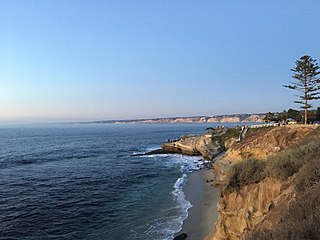
La Jolla is a hilly, seaside community within San Diego, occupying 7 miles (11 km) of curving coastline along the Pacific Ocean. The population reported in the 2010 census was 46,781.

Black's Beach is a secluded section of beach beneath the bluffs of Torrey Pines on the Pacific Ocean in La Jolla, San Diego, California, United States. It is officially part of Torrey Pines State Beach. The northern portion of Black's Beach is owned and managed by the California Department of Parks and Recreation, while the southern portion of the beach, officially known as Torrey Pines City Beach, is jointly owned by the city of San Diego and the state park, but is managed by the city of San Diego. This distinction is important as Black's Beach is most known as a nude beach, a practice that is now prohibited in the southern portion managed by the city of San Diego.

Torrey Pines State Beach is a public beach located in the San Diego, California community of Torrey Pines, south of Del Mar and north of La Jolla. Coastal erosion from the adjacent Torrey Pines State Reserve makes for a picturesque landscape. It is a local favorite among surfers and remains a quintessential Southern California beach. Occurrences of bioluminescence in the waters near the beach have been noted.
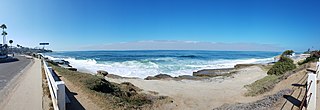
Windansea Beach is a stretch of coastline located in the La Jolla community of San Diego, California. The neighborhood adjacent to the beach is named Windansea after the beach. It is named after the 1909 oceanfront Strand Hotel that was renamed "Windansea" Hotel in 1919 after the owner Arthur Snell ran a "naming contest". The Windansea Hotel which was located on Neptune Avenue between Playa del Sur and Playa del Norte burned down in 1943. Geographically, it is defined by the beachfront extending north of Palomar Avenue and south of Westbourne Street.

Michael Dormer or Michael Henry Dashwood Dormer was an American fine artist, writer, songwriter, entrepreneur, and creator of the 1960s TV show Shrimpenstein.

The Children's Pool Beach or Casa Beach is a small sandy beach area located at 850 Coast Boulevard, at the end of Jenner Street, in San Diego, California, United States.
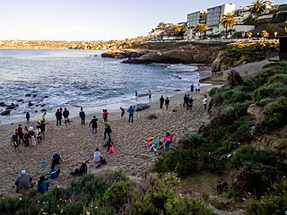
La Jolla Cove is a small cove with a beach that is surrounded by cliffs in La Jolla, San Diego, California. Point La Jolla forms the south side of the cove. The area is protected as part of a marine reserve and is popular with snorkelers, swimmers and scuba divers.
La Jolla Shores, with its northern part Scripps Beach, is a beach and vacation/residential community of the same name in La Jolla, San Diego, California. The La Jolla Shores business district is a mixed-use village encircling Laureate Park on Avenida de la Playa in the village of La Jolla Shores.
Bill Andrews (1944-2017) was a surfer, documentary photographer/videographer, and archivist. During his daily reportage of modern surf culture, Andrews archived over 20,000 surf-related photographs and videos. His work can be seen on the online chronicle "A Day with BA" and on youtube.

Swami's is an area in San Diego County that contains Swami's Beach and other local attractions. The beach, also known as "Swami’s Reef'" and "Swamis", is an internationally known surfing spot, a point break located in Encinitas, San Diego County, California. Swami's was named after Swami Paramahansa Yogananda, because the grounds and hermitage of the Self-Realization Fellowship ashram, built in 1937, overlook this reef point. The name "Swami's" is also given to the sand beach that extends south from the point to the next beach access point, which is next to the San Elijo State Beach camping area; this more southerly surf spot often goes by the name "Pipes".

The San Diego-La Jolla Underwater Park spans 6,000 acres (24 km2) of ocean bottom and tidelands. The park's four distinct habitats make it a popular destination for snorkelers and scuba divers. The park was created by the City of San Diego in 1970 and actually has two other parks within it: the "look but don't touch" Ecological Reserve and the Marine Life Refuge.

Bronte Beach is a small but popular recreational beach in the Eastern Suburbs of Sydney, Australia. It is a division of the LGA of Waverley Council. Bronte Beach is 2 kilometres south of Bondi Beach and north of the much larger Coogee Beach.

Moonlight State Beach is a state beach in Encinitas, California. It is located one fifth of one mile beyond the point where Encinitas Boulevard turns into B Street after it crosses Highway 101.
San Diego-Scripps Coastal Marine Conservation Area (SMCA) and Matlahuayl State Marine Reserve (SMR) are adjoining marine protected areas that extend offshore from La Jolla in San Diego County on California's south coast. The two marine protected areas cover 2.51 square miles (6.5 km2). San Diego-Scripps Coastal SMCA prohibits the take of all living marine resources except that coastal pelagic species, not including market squid, may be taken recreationally by hook and line. Matlahuayl SMR prohibits the take of all living marine resources.
South La Jolla State Marine Conservation Area (SMCA) and South La Jolla State Marine Reserve (SMR) are two adjoining marine protected areas that extend offshore in San Diego County on California’s south coast. The two marine protected areas cover 7.51 square miles. The SMR protects marine life by prohibiting the removal of marine wildlife from within its borders, while the SMCA limits removal of marine wildlife.
Swami’s State Marine Conservation Area (SMCA) is a marine protected area that extends offshore of Encinitas in San Diego County on California’s south coast. The SMCA covers 12.65 square miles. The SMCA protects marine life by limiting the removal of marine wildlife from within its borders.
Lifeguard! Southern California is an American reality television series on The Weather Channel and narrated by Christopher Emerson which puts cameras on Southern California beaches from Los Angeles County in the north to San Diego County in the south. The cameras follow real life lifeguards and harbor patrol officers along 150 miles of Southern California beaches as they perform their rescue and law enforcement activities. The lifeguards tell of the people who come to their beaches, their jobs and the dangers that their beaches pose like water dangers, and dangers presented by marine life. All of the rescues, first aid and law enforcement shown are recorded by the cameras in real time. Victims and victim's families are also interviewed during the recording of the show.
County Line Beach is a beach located in Solromar, California, an unincorporated community of Ventura County. This stretch of sandy beach is easily accessible from the adjacent Pacific Coast Highway. This surf spot popularized by the Beach Boys in their 1963 hit song "Surfin' U.S.A." is administered by the California State Parks' Malibu Sector Coastal Lifeguard Program in addition to Leo Carrillo State Park. The beach lies within the south coast portion of Ventura County amidst a mostly rugged coastline that is some of the most striking and diverse coastal terrain in the County and a backdrop for many televised car scenes. The beach lies at the mouth of a canyon in the Santa Monica Mountains that hugs the shore along the Ventura County's south coast.

Tourmaline Surfing Park is a beach access point and a surf spot in North Pacific Beach, San Diego, California, USA. The park is situated at the northern end of Pacific Beach, a short distance south of where the sand beach ends and the rocky promontory of La Jolla begins. There are cliffs to the north and south of Tourmaline Surfing Park, but the park itself lies in Tourmaline Canyon, which cuts down through those cliffs to the beach.

