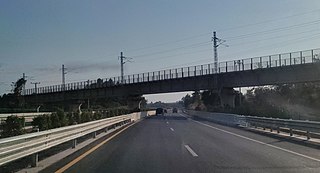
This article concerns the systems of transportation in Laos. Laos is a country in Asia, which possesses a number of modern transportation systems, including several highways and a number of airports. As a landlocked country, Laos possesses no ports or harbours on the sea, and the difficulty of navigation on the Mekong means that this is also not a significant transport route.

The River Avon is a river in the southwest of England. To distinguish it from a number of other rivers of the same name, it is often called the Bristol Avon. The name 'Avon' is loaned from an ancestor of the Welsh word afon, meaning 'river'.

The Welland Canal is a ship canal in Ontario, Canada, and part of the St. Lawrence Seaway and Great Lakes Waterway. The canal traverses the Niagara Peninsula between Port Weller on Lake Ontario, and Port Colborne on Lake Erie, and was erected because the Niagara River—the only natural waterway connecting the lakes—was unnavigable due to Niagara Falls. The Welland Canal enables ships to ascend and descend the Niagara Escarpment, and has followed four different routes since it opened.
Southport is a seaside town in the Metropolitan Borough of Sefton in Merseyside, England. It lies on the West Lancashire coastal plain and the east coast of the Irish Sea, approximately 17 miles (27 km) north of Liverpool and 15 miles (24 km) southwest of Preston. At the 2021 census, Southport had a population of 94,421, making it the eleventh most populous settlement in North West England and the third most populous settlement in the Liverpool City Region.
The Nerang River is a perennial river in South East Queensland, Australia. Its catchment lies within the Gold Coast local government area and covers an area of 490 square kilometres (190 sq mi). The river is approximately 62 kilometres (39 mi) in length.

The Liverpool, Crosby and Southport Railway was a British railway company, which opened a line in 1848 between Southport and Waterloo, extending into Liverpool in 1850. The company was acquired by the Lancashire and Yorkshire Railway in 1855. The line is still open.

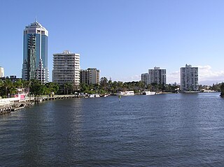
Southport is a coastal town and suburb in the City of Gold Coast in Queensland, Australia. It contains the Gold Coast central business district. In the 2021 census, Southport had a population of 36,786 people.

The Kap Shui Mun Bridge (KSMB) in Hong Kong, part of Lantau Link of Route 8, is one of the longest cable-stayed bridges in the world that transports both road and railway traffic, with the upper deck used for motor vehicles and the lower deck for both vehicles and the MTR. It has a main span of 430 metres (1,410 ft) and an overall length of 750 metres (2,460 ft). It spans the Kap Shui Mun marine channel between Ma Wan and Lantau islands and has a vertical clearance of 47 metres (154 ft) above sea level. The bridge was completed in 1997.

Walbury Hill is a summit of the North Wessex Downs in Berkshire, England. With an elevation of 297 metres (974 ft), it is the highest natural point in South East England. On the hill's summit is the Iron Age hill fort of Walbury Camp, whilst the flanks of the hill lie within the Inkpen and Walbury Hills SSSI. The hill is one of three nationally important chalk wild grasslands in the North Wessex Downs, the others being in the Rushmore and Conholt Downs SSSI and the Hog's Hole SSSI. The summit of the hill is marked by a triangulation pillar, but lies on private land with no public access, although public access is available to the north of the summit via a byway.

The Gold Coast Broadwater, also known as Southport Broadwater, Gold Coast Harbour and The Broadwater, is a large shallow estuary of water located in the Gold Coast district of South East Queensland, Australia. The estuary reaches from the locality of Southport in the south, to the southern section of the UNESCO World Heritage Listed Moreton Bay in the north. Separated via the Seaway from the Coral Sea by a thin strip of land called Stradbroke Island, the original body of water was a lagoon created from water deposited from the Nerang River. Part of the Broadwater is contained within the Moreton Bay Marine Park.

The Arthur Laing Bridge is a crossing over the north arm of the Fraser River, and several minor roads, in Metro Vancouver.

Australia Fair Shopping Centre is a dual-level regional shopping centre covering 59,540 square metres (640,900 sq ft) located in Southport, Gold Coast, Queensland. The centre also incorporates a five-level office tower comprising 5,824 square metres (62,690 sq ft) of office space, housing specialist services and commercial offices.
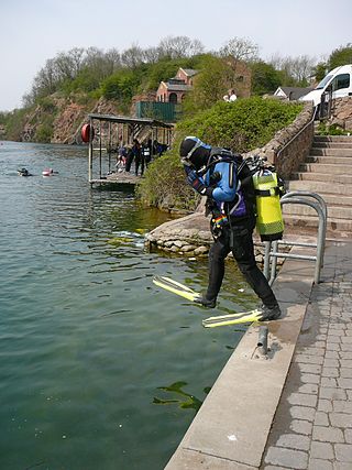
Stoney Cove is a large flooded quarry which is a popular inland scuba diving site, located between Stoney Stanton and Sapcote in Leicestershire, England.

The Sea Cliff Bridge, together with the adjoining Lawrence Hargrave Drive Bridge, are two road bridges that carry the scenic Lawrence Hargrave Drive across the rockface on the Illawarra escarpment, located in the northern Illawarra region of New South Wales, Australia. The balanced cantilever and incremental launching girder bridges link the coastal villages of Coalcliff and Clifton and carry two lanes of traffic, and a pedestrian walkway.

SEA LIFE Sydney Aquarium is a public aquarium in Sydney, Australia. Opened in 1988, it features a large variety of Australian aquatic life, displaying more than 700 species comprising more than 13,000 individual fish and other sea and water creatures from most of Australia's water habitats.

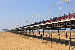
Southport Pier is a pleasure pier in Southport, Merseyside, England. Opened in August 1860, it is the oldest iron pier in the country. Its length of 1,108 m (3,635 ft) makes it the second-longest in Great Britain, after Southend Pier. Although at one time spanning 1,340 m (4,380 ft), a succession of storms and fires during the late 19th and early 20th centuries reduced its length to that of the present day.

The North Arm Bridge is an extradosed bridge in Metro Vancouver, British Columbia, Canada. It spans the north arm of the Fraser River, linking Vancouver to Richmond. It is used by trains on the Canada Line, which opened in August 2009.
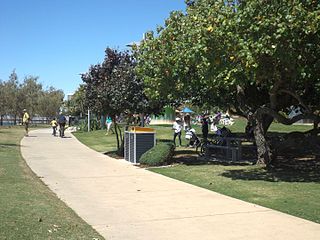
The Southport Broadwater Parklands is a large community park located in Southport. It is designed for large community gatherings and families. The park has many different areas for children and barbecue areas for families. The park went through a major redevelopment and was re-opened by the Premier of Queensland, Anna Bligh, on 23 August 2009. Southport Broadwater Parklands has become a popular family attraction.

The Grand Narrows Bridge is a Canadian railway bridge crossing between Victoria County, Nova Scotia, and Cape Breton County. At 516.33 m (1,694 ft), it is the longest railroad bridge in the province. The bridge incorporates a swing span at its eastern end to permit the continued passage of marine traffic through the strait.

Darwin's Arch was a natural rock arch feature to the south-east of Darwin Island in the Galápagos Archipelago in the Pacific Ocean, and is now a pillar formation. The arch sat on an irregularly shaped, rocky, submerged plateau, nicknamed "the theatre". The arch collapsed into the sea on 17 May 2021 from natural erosion.

