
Podkarpackie Voivodeship or Podkarpackie Province, also known as Subcarpathian Voivodeship or Subcarpathia Province, is a voivodeship, or province, in extreme-southeastern Poland. Its administrative capital and largest city is Rzeszów..
Baranów Sandomierski is a small town in southern Poland, in the Subcarpathian Voivodship, Tarnobrzeg County on the Vistula River, with 1,440 inhabitants (02.06.2009). Baranów lies near the Vistula river, along regional road nr. 985, which goes from Tarnobrzeg to Mielec. It belongs to the historic province of Lesser Poland, and for centuries was part of the Sandomierz Voivodeship. Its name comes either from sheep husbandry, which was prevalent in this area in the past, or from the Baranowski family, owners of the town.
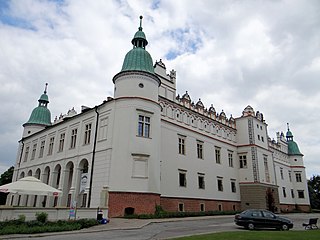
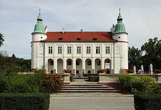
The Baranów Sandomierski Castle is a Mannerist castle located in the town of Baranów Sandomierski in the Subcarpathian Voivodship, south-eastern Poland. It is one of the most important Mannerist structures in the country. The castle is commonly known as the "little Wawel". Originally a residency of the Lubomirski family, it now serves as a historical museum, hotel and conference centre.
Gmina Nowa Dęba is an urban-rural gmina in Tarnobrzeg County, Subcarpathian Voivodeship, in south-eastern Poland. Its seat is the town of Nowa Dęba, which lies approximately 18 kilometres (11 mi) south of the town of Tarnobrzeg and 48 km (30 mi) north of the regional capital Rzeszów.
Gmina Łoniów is a rural gmina in Sandomierz County, Świętokrzyskie Voivodeship, in south-central Poland. Its seat is the village of Łoniów, which lies approximately 21 kilometres (13 mi) south-west of Sandomierz and 74 km (46 mi) south-east of the regional capital Kielce.

Bazów is a village in the administrative district of Gmina Łoniów, within Sandomierz County, Świętokrzyskie Voivodeship, in south-central Poland. It lies approximately 7 kilometres (4 mi) north-west of Łoniów, 24 km (15 mi) south-west of Sandomierz, and 67 km (42 mi) south-east of the regional capital Kielce.
Dąbrowica is a village in the administrative district of Gmina Baranów Sandomierski, within Tarnobrzeg County, Subcarpathian Voivodeship, in south-eastern Poland. It lies approximately 7 kilometres (4 mi) east of Baranów Sandomierski, 13 km (8 mi) south-west of Tarnobrzeg, and 58 km (36 mi) north-west of the regional capital Rzeszów.
Durdy is a village in the administrative district of Gmina Baranów Sandomierski, within Tarnobrzeg County, Subcarpathian Voivodeship, in south-eastern Poland. It lies approximately 11 kilometres (7 mi) south-east of Baranów Sandomierski, 20 km (12 mi) south of Tarnobrzeg, and 52 km (32 mi) north-west of the regional capital Rzeszów.
Dymitrów Duży is a village in the administrative district of Gmina Baranów Sandomierski, within Tarnobrzeg County, Subcarpathian Voivodeship, in south-eastern Poland. It lies approximately 4 kilometres (2 mi) south of Baranów Sandomierski, 18 km (11 mi) south-west of Tarnobrzeg, and 60 km (37 mi) north-west of the regional capital Rzeszów.
Dymitrów Mały is a village in the administrative district of Gmina Baranów Sandomierski, within Tarnobrzeg County, Subcarpathian Voivodeship, in south-eastern Poland. It lies approximately 3 kilometres (2 mi) south-west of Baranów Sandomierski, 18 km (11 mi) south-west of Tarnobrzeg, and 62 km (39 mi) north-west of the regional capital Rzeszów.
Kaczaki is a village in the administrative district of Gmina Baranów Sandomierski, within Tarnobrzeg County, Subcarpathian Voivodeship, in south-eastern Poland. It lies approximately 11 kilometres (7 mi) south-east of Baranów Sandomierski, 14 km (9 mi) south of Tarnobrzeg, and 53 km (33 mi) north-west of the regional capital Rzeszów.
Knapy is a village in the administrative district of Gmina Baranów Sandomierski, within Tarnobrzeg County, Subcarpathian Voivodeship, in south-eastern Poland. It lies approximately 8 kilometres (5 mi) south of Baranów Sandomierski, 19 km (12 mi) south-west of Tarnobrzeg, and 55 km (34 mi) north-west of the regional capital Rzeszów.
Siedleszczany is a village in the administrative district of Gmina Baranów Sandomierski, within Tarnobrzeg County, Subcarpathian Voivodeship, in south-eastern Poland. It lies approximately 5 kilometres (3 mi) east of Baranów Sandomierski, 11 km (7 mi) south-west of Tarnobrzeg, and 60 km (37 mi) north-west of the regional capital Rzeszów.
Skopanie is a village in the administrative district of Gmina Baranów Sandomierski, within Tarnobrzeg County, Subcarpathian Voivodeship, in south-eastern Poland. It lies approximately 5 kilometres (3 mi) south-east of Baranów Sandomierski, 16 km (10 mi) south-west of Tarnobrzeg, and 58 km (36 mi) north-west of the regional capital Rzeszów.
Ślęzaki is a village in the administrative district of Gmina Baranów Sandomierski, within Tarnobrzeg County, Subcarpathian Voivodeship, in south-eastern Poland. It lies approximately 8 kilometres (5 mi) south-east of Baranów Sandomierski, 14 km (9 mi) south of Tarnobrzeg, and 55 km (34 mi) north-west of the regional capital Rzeszów.
Suchorzów is a village in the administrative district of Gmina Baranów Sandomierski, within Tarnobrzeg County, Subcarpathian Voivodeship, in south-eastern Poland. It lies approximately 4 kilometres (2 mi) east of Baranów Sandomierski, 12 km (7 mi) south-west of Tarnobrzeg, and 60 km (37 mi) north-west of the regional capital Rzeszów.
Wola Baranowska is a village in the administrative district of Gmina Baranów Sandomierski, within Tarnobrzeg County, Subcarpathian Voivodeship, in south-eastern Poland. It lies approximately 7 kilometres (4 mi) south-east of Baranów Sandomierski, 17 km (11 mi) south-west of Tarnobrzeg, and 56 km (35 mi) north-west of the regional capital Rzeszów.
Sandomierz bridgehead, also known as Sandomierz-Baranów bridgehead was a pocket of resistance created by Red Army's 1st Ukrainian Front in late July 1944 on the left bank of the Vistula River in German-occupied Poland. Located around the towns of Sandomierz and Baranów, it covered roughly 40 by 70 kilometres.


