
Goodyear is a city in Maricopa County, Arizona, United States. It is a suburb of Phoenix and at the 2010 census had a population of 65,275, the third fastest-growing city in Arizona between 1990 and 2000. The 2017 population estimate was 79,858.

Arizona City is a census-designated place (CDP) in southwestern Pinal County, Arizona, in the United States. It is located near the junction of Interstate 8 and Interstate 10 at the midpoint between Phoenix and Tucson, approximately 60 miles (97 km) from the downtown of both cities. The population was 10,475 at the 2010 census. Arizona City is a rural, primarily residential community that features a semi-private golf club and a 48-acre man made lake. These attributes make the community a popular snowbird destination, with the population increasing by as much as 5,000 people in the winter months to reach the census figure of 10,475.
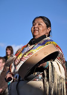
The Havasupai people are an American Indian tribe who have lived in the Grand Canyon for at least the past 800 years. Havasu means "blue-green water" and pai "people".

South Mountain Park in Phoenix, Arizona is the largest municipal park in the United States, and one of the largest urban parks in North America and in the world. It has been designated as a Phoenix Point of Pride.

Northern Arizona is an unofficial, colloquially-defined region of the U.S. state of Arizona. Generally consisting of Coconino, Mohave, Navajo, and Apache counties, the region is geographically dominated by the Colorado Plateau, the southern border of which in Arizona is called the Mogollon Rim.

The Santa Cruz River is a river in Southern Arizona and northern Sonora, Mexico. It is approximately 184 miles (296 km) long.

KSLX-FM is a Classic rock radio station serving the Phoenix, Arizona area. The Hubbard Broadcasting, Inc. outlet broadcasts at 100.7 MHz with an ERP of 100 kW and is licensed to Scottsdale, Arizona. KSLX simulcasts in digital HD Radio. Its studios are located on North 52nd Street west of Papago Park and its transmitter is in South Mountain Park.

McCormick Ranch refers to an area in Scottsdale, Arizona, which is one of the largest planned communities in Arizona.

Encanto Park is a public park in central Phoenix, Arizona. The park is composed of 222 acres (0.90 km2) of land consisting of picnic areas, a lagoon, a boat house, swimming pool, nature trail, amusement park, fishing and two golf courses. The lagoon is approximately 7.5 acres (0.030 km2) in surface area and about 6 feet (1.8 m) deep, on average. The park is bounded by Thomas Road on the north, Encanto Boulevard on the south, 15th Avenue on the west and 7th Avenue on the east and is at a surface elevation of 1,100 ft (340 m).
Ford Motor Company operates several proving grounds worldwide, for development and validation testing of new vehicles.

National Memorial Cemetery of Arizona is a United States National Cemetery located in the city of Phoenix in Maricopa County, Arizona. It encompasses 225 acres (91 ha), and as of the end of 2005, had 43,672 interments. It is one of two national cemeteries in Arizona (the other being Prescott.
South Phoenix is a region of Phoenix, Arizona.
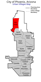
Rio Vista Village is the fifteenth designated urban village of Phoenix, Arizona, located in the northern part of the city. The village consists primarily of largely undeveloped land, and is located near the unincorporated master-planned community of Anthem. Developed areas include the Anthem Commerce Park, Anthem Outlets, and the Anthem West single-family home community. Much of the undeveloped land is owned by the Arizona State Land Department.
Chrysler LLC operates proving grounds around North America, for development and validation testing of new vehicles.

Alhambra Elementary School District provides education for more than 14,000 students in the Phoenix and Glendale areas of Arizona. Alhambra has 15 schools. These schools educate students from kindergarten to eighth grade. The district feeds into Phoenix Union High School District.
Douglas Ranch is a proposed 33,800-acre (137 km2) community in Buckeye, Arizona, located 25 miles (40 km) west of Phoenix, Arizona, United States. The project had been anticipated to break ground in 2012, but was delayed due to a housing crisis that overtook the Phoenix metropolitan area in 2008. Development resumed in 2019.

The Belmont Mountains are a 25 mi (40 km) long, arid, low elevation mountain range about 50 mi west of Phoenix, Arizona in the northern Sonoran Desert, north of the Gila River. The range is in the south of a region of two parallel washes; the Bouse Wash flows northwest to the Colorado River, and the Centennial Wash flows southeast to meet the Gila River.

The Phoenix Mountains Preserve is a group of parks located among the Phoenix Mountains in Phoenix, Arizona, United States. The Phoenix Mountains Park and Recreation Area, the first of these parks to be preserved, has been designated as a Phoenix Point of Pride.. Two of the parks rank among the world's largest city parks.

Deer Valley or Deer Valley Village is one of the 15 urban villages that make up Phoenix, Arizona, United States. As of 2010, the population was 165,656, 25% of whom were under 18 years of age. The origin of the name is unclear; it first appeared on a 1921 General Land Office map of the area describing the valley created by Skunk Creek.
Belmont is a proposed planned city in the Phoenix metropolitan area of Arizona, United States. The development, a partnership between billionaire philanthropist Bill Gates and local real estate investors, will be a "smart city" designed around emerging technologies. It is located in the West Valley area, along Interstate 10 near Tonopah.


