The Calder and Hebble Navigation is a broad inland waterway, with locks and bridgeholes that are suitable for 14-foot-wide (4.3 m) boats, in West Yorkshire, England. Construction to improve the River Calder and the River Hebble began in 1759, and the initial scheme, which included 5.7 miles (9.2 km) of new cuts, was completed in 1770 and has remained navigable since it was opened. Significant improvements were made, including the Salterhebble branch to Halifax, opened in 1828, and ever-longer cuts to bypass river sections. Trade was assisted by the opening of the Rochdale Canal in 1804, which provided a through route from Sowerby Bridge to Manchester. There were plans to abandon the river sections completely in the 1830s, but these were modified as the needs of mill owners and other riparian landowners were recognised.

The Peak Forest Canal is a narrow locked artificial waterway in northern England. It is 14.8 miles (23.8 km) long and forms part of the connected English/Welsh inland waterway network.

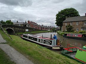
The Macclesfield Canal is a canal in east Cheshire, England. There were various proposals for a canal to connect the town of Macclesfield to the national network from 1765 onwards, but it was not until 1824 that a scheme came to fruition. There were already suggestions by that date that a railway would be better, but the committee that had been formed elected for a canal and the engineer Thomas Telford endorsed the decision. The canal as built was a typical Telford canal, constructed using cut and fill, with numerous cuttings and embankments to enable it to follow as straight a course as possible, although Telford had little to do with its construction, which was managed by William Crosley.
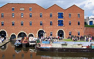
The Bugsworth Basin Heritage Trust (BBHT), formerly known as the Inland Waterways Protection Society (IWPS), is a British organisation founded in 1958 to work for the restoration of the canal system. Its members carried out surveys of canals and produced reports in support of their retention when much of the canal network was under threat. Following official support for use of the canals for leisure activities in 1967, the Society have concentrated their efforts on the restoration and operation of Bugsworth Basin, located at the southern end of the Peak Forest Canal, which was one of the first canals that they surveyed in 1958.

Bosley Reservoir is a large reservoir created to feed the Macclesfield Canal system, specifically the twelve Bosley locks. It is fed from the surrounding hills, including Bosley Cloud which rises to 1,125 feet.

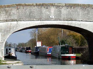
A large number of canals were built in Cheshire, England, during the early phases of the Industrial Revolution to transport goods and raw materials. This resulted in a significant canal network which is now enjoyed by holiday-makers, anglers, walkers, and others.

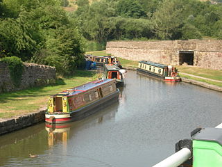
The Cheshire Ring is a canal cruising circuit or canal ring, which includes sections of six canals in and around Cheshire and Greater Manchester in North West England: the Ashton Canal, Peak Forest Canal, Macclesfield Canal, Trent and Mersey Canal, Bridgewater Canal and Rochdale Canal.

Aldersley Junction is the name of the canal junction where the Birmingham Main Line Canal terminates and meets the Staffordshire and Worcestershire Canal near to Oxley, north Wolverhampton, West Midlands, England. It opened in 1772.

The South Pennine Ring is an English canal ring which crosses the Pennines between Manchester and Huddersfield. It covers parts of five canals, and includes passage through the longest canal tunnel in Britain. It has only been possible to cruise it since 2002, when restoration of the Huddersfield Narrow Canal provided the return route across the Pennines.

The Four Counties Ring is a canal ring which links the four English counties of Cheshire, Staffordshire, Shropshire and West Midlands.

The North Pennine Ring is a canal ring which crosses the Pennines between Manchester, Leeds and Castleford. It follows parts of five canals, and shares much of its route with the Outer Pennine Ring, which uses a different route for the southern crossing of the Pennines.

The Outer Pennine Ring is an English canal ring which crosses the Pennines between Manchester, Leeds and Castleford. Its route follows parts of eight canals, and includes the longest canal tunnel in England. The ring was completed in 2001, with the opening of the Huddersfield Narrow Canal. Much of the route is shared with the North Pennine Ring, which crosses the Pennines by a different route on the southern leg.

Bosley Lock Flight is a flight of twelve canal locks, situated on the Macclesfield Canal at Bosley, near Macclesfield, Cheshire, England. The locks are substantially built with stone blocks, and unusually for narrow locks have mitre gates at both ends. They were each built with a side pond, which enabled some of the water to be re-used during a filling and emptying cycle. The side ponds have been disused for many years, but there are plans to reinstate one of them for demonstration purposes.
Dukinfield Junction is the name of the canal junction where the Peak Forest Canal, the Ashton Canal and the Huddersfield Narrow Canal meet near Ashton-under-Lyne, Greater Manchester, England. The area has been designated by Tameside Metropolitan Borough Council as a conservation area.

Hurleston Junction is the name of the canal junction where the Llangollen Canal terminates and meets the Shropshire Union Canal main line at Hurleston, Cheshire, England.
Rushall Junction is the southern limit of the Rushall Canal where it meets the Tame Valley Canal in the West Midlands, England. It opened in 1847, when the Rushall Canal was built to create connections between the Birmingham Canal Navigations system and the Wyrley and Essington Canal, following the amalgamation of the two companies in 1840.

Huddlesford Junction is a canal junction at the original north-eastern limit of the Wyrley and Essington Canal where it met the Coventry Canal, near Lichfield, in Staffordshire, England.
Barbridge Junction is the name of the canal junction located at Barbridge, Cheshire, where the Shropshire Union Canal Middlewich Branch terminates and meets the Shropshire Union Canal main line.

Delph Locks or the Delph Nine are a series of eight narrow canal locks on the Dudley No. 1 Canal in Brierley Hill, in the West Midlands, England. They were opened in 1779, and reopened in 1967 following restoration of the Dudley Canal and the Stourbridge Canal in a joint venture between the Staffordshire and Worcestershire Canal Society and the British Waterways Board.

Hardings Wood Junction is a canal junction near Kidsgrove, Staffordshire, England and the point at which the Macclesfield Canal joins the Trent and Mersey Canal. It opened in 1831.