The Kenya-Turbi City massacre was the killing of fifty-six people by feuding clans in the remote Marsabit District of Northern Kenya on the early morning of 12 July 2005. Hundreds of armed raiders of the Borana tribe attacked the Gabra people living in the Turbi area northwest of Marsabit. Twenty-two of the sixty confirmed dead were children, and over six thousand people fled their homes, most fleeing to Marsabit town. The massacre's aftermath sparked several violent inter-clan conflicts, raising the death toll to ninety-five.
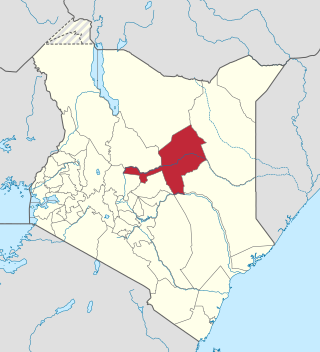
Marsabit County is a county in Kenya. Covering a surface area of 66,923.1 square kilometres. Marsabit is the second largest county by size in Kenya after Turkana county which has an area of 71,597.8 km2. Its capital is Marsabit and its largest town is Moyale. According to the 2019 census, the county has a population of 459,785. It is bordered to the North by Ethiopia, to the West by Turkana County to the South by Samburu County and Isiolo County, and to the East by Wajir County.
Isiolo County is a county in the former Eastern Province of Kenya. Its population is 268,002 and its capital and largest city is Isiolo. Isiolo County is to be the first county to be developed as part of the Kenya Vision 2030 program. Other upcoming urban centres are: Garbatulla, Modogashe, Kinna, Merti and Oldonyiro.The county is home to Sakuye and Borana tribes but also has a significant number of people from Turkana, Samburu, Gabra, Garre and Meru communities.

Turkana County is a county in the former Rift Valley Province of Kenya. It is Kenya's second largest county by land area of 98,597.8km2 followed by Marsabit County with an area of 71,597.8km2. It is bordered by the countries of Uganda to the west; South Sudan and Ethiopia, including the disputed Ilemi Triangle, to the north and northeast; and Lake Turkana to the east. To the south and east, neighbouring counties in Kenya are West Pokot, Baringo and Samburu Counties, while Marsabit County is on the opposite shore of Lake Turkana. Turkana's capital and largest town is Lodwar. The county had a population of 926,976 at the 2019 census.
Mandera County is one of the counties in Kenya. Its capital and largest town is Mandera. The county is bordered by Ethiopia to the north, Somalia to the east and Wajir County to the southwest. According to the 2019 census, the county has a population of 1,200,890 and an area of 25,939.8 square kilometres (10,015.4 sq mi). The main economic activity in the county is pastoralism, while others include cross-border trade with Ethiopia, artisanal mining, beekeeping, and agriculture along the Dawa River.

Wajir County is a county in the former North Eastern Province of Kenya. Its capital and largest town is Wajir. The county has a population of 781,263 and an area of 55,840.6 km2 (21,560.2 sq mi). The county is bordered to the north by Ethiopia, to the northeast by Mandera County, to the east by Somalia, to the south by Garissa County, to the west by Isiolo County and to the northwest by Marsabit County. The county has six constituencies: Wajir South, Tarbaj, Wajir North, Wajir West, Wajir East, and Eldas.
Moyale District is a former administrative district in the former Eastern Province of Kenya. Its capital town was Moyale. It had population of 53,479 and an area of 9,390 km². The district had only one local authority, Moyale county council. The district had one electoral constituency, the Moyale Constituency.

North Horr Constituency is an electoral constituency in Kenya. It is one of four constituencies in Marsabit County. The entire constituency is located within Marsabit County Council area. The constituency was established for the 1988 elections. It is the largest constituency in Kenya on land coverage and hosts the only true desert in Kenya, Chalbi desert. Kenya's well known politician Godana Bonaya was its first member of parliament, and he represented the constituency until his demise in a Kenya Air Force Y-12 plane crash on 10 April 2006 in which all the legislators from Marsabit county perished.

Laisamis Constituency is an electoral constituency in Kenya. It is one of four constituencies in Marsabit County. The entire constituency is located within Marsabit County Council area. The constituency was established for the 1988 elections. Formally known as Marsabit South, it was represented by Hon. Phillip Kurungu in the 1966 elections. From 1969-1988 Laisamis Constituency was represented by Hon. Haji Kholkhale Adichareh. Hon. Adichareh was a Lancaster House Conference delegate and was a fierce defender of Rendille land. He served 7 years at Shimo La Tewa prison on trumped up charges and emerge to lead his Rendille community for 20 years in parliament.
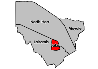
Marsabit central (Saku Constituency) is an electoral constituency in Kenya. It is one of four constituencies in Marsabit County in Northern Kenya. It borders North Horr Constituency to the North and Laisamis Constituency to the South. The constituency was established for the 1988 elections. Marsabit town which is the county headquarters is in Saku constituency.

Moyale Constituency is an electoral constituency in Kenya. It is one of four constituencies in Marsabit County, and it was the only constituency in the former Moyale District. The constituency has nine wards, all electing councillors to the Moyale County Council. The constituency was established for the 1966 elections.

North Horr is a settlement and Sub-County in Kenya's former Eastern Province. It is now a part of Marsabit County.
Marsabit Airport is an airport in Marsabit, Kenya.

Sub-counties, also known as Districts, are the decentralised units through which government of Kenya provides functions and services. At national level, sub-counties take a more administrative function like security, statistical purposes, provision of government services, etc. Even though the sub-counties are divisions of counties, powers to create new national sub-counties lies with the national government. As of 2023, there are 314 sub-counties, compared to 290 constituencies. A deputy county commissioner is appointed by the state to lead each sub-county. The sub-counties are further divided into divisions, locations and sub-locations.
Mandera District was an administrative district in the North Eastern Province of Kenya. Its capital town was Mandera. The district had an area of 26,744 km2.
Isiolo District was an administrative district in Eastern Province of Kenya, with its capital at Isiolo town.
Garissa District was an administrative district in the North Eastern Province of Kenya. The district is one the districts created by the British colonial government in 1963, carving it out of the then Northern Frontier District. Its capital town was Garissa. The district had a population of 329,939. The district had an area of 44,952 km². before the Ijara District was split from it in 2002.
Kitui District was an administrative district in the Eastern Province of Kenya. Its capital was Kitui. The district had an area of 20,402 km².
Charles Karuga Koinange (1920-2004), the son of a prominent colonial Kikuyu chief, served as key colonial chief in Central Kenya during the 1950s. After Kenya's independence in 1963, Charles Karuga served as a District Commissioner and Provincial Commissioner in the independent Republic of Kenya. As a leading member of the prominent Koinange family, Charles Karuga Koinange held a prominent role in late colonial developments in Central Kenya, as well as politics in Central Kenya following Kenya's independence.

Ukur Yatani Kanacho is a Kenyan politician and ambassador, and was appointed as Treasury Secretary on 14 January 2020.