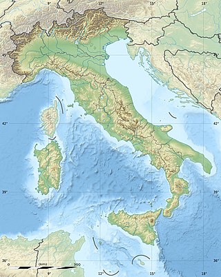
The geography of Italy includes the description of all the physical geographical elements of Italy. Italy, whose territory largely coincides with the homonymous geographical region, is located in southern Europe and comprises the long, boot-shaped Italian Peninsula crossed by the Apennines, the southern side of Alps, the large plain of the Po Valley and some islands including Sicily and Sardinia. Italy is part of the Northern Hemisphere. Two of the Pelagie Islands are located on the African continent.

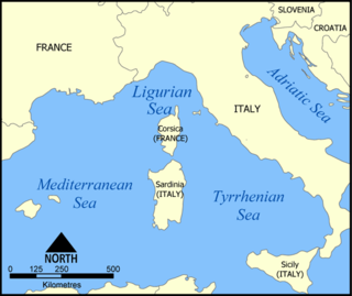
The Tyrrhenian Sea is part of the Mediterranean Sea off the western coast of Italy. It is named for the Tyrrhenian people identified with the Etruscans of Italy.

The Volturno is a river in south-central Italy.
The volcanism of Italy is due chiefly to the presence, a short distance to the south, of the boundary between the Eurasian Plate and the African Plate. Italy is a volcanically active country, containing the only active volcanoes in mainland Europe. The lava erupted by Italy's volcanoes is thought to result from the subduction and melting of one plate below another.
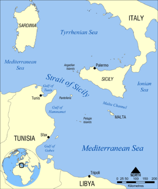
The Strait of Sicily is the strait between Sicily and Tunisia. The strait is about 145 kilometres (90 mi) wide and divides the Tyrrhenian Sea and the western Mediterranean Sea, from the eastern Mediterranean Sea. The maximum depth is 316 meters (1,037 ft).
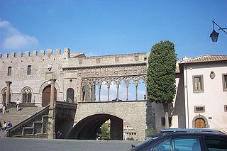
Viterbo is a province in the Lazio region of Italy. Its capital is the city of Viterbo.
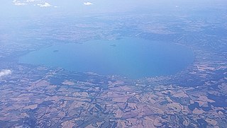
Lake Bolsena is a lake of volcanic origin in the northern part of the province of Viterbo called Alto Lazio or Tuscia in central Italy. It is the largest volcanic lake in Europe. Roman historic records indicate activity of the Vulsini volcano occurred as recently as 104 BC; it has been dormant since then. The two islands in the southern part of the lake were formed by underwater eruptions following the collapse that created the depression.

Tarquinia, formerly Corneto, is an old city in the province of Viterbo, Lazio, Central Italy, known chiefly for its ancient Etruscan tombs in the widespread necropoleis, or cemeteries, for which it was awarded UNESCO World Heritage status.

The Lao is a river in southern Italy. It rises in the Lucanian Apennines in Basilicata and drains into the Tyrrhenian Sea near Scalea in Calabria.

Ostia is a large neighbourhood in the X Municipio of the comune of Rome, Italy, near the ancient port of Rome, which is now a major archaeological site known as Ostia Antica. Ostia is also the only municipio or district of Rome on the Tyrrhenian Sea, and many Romans spend the summer holidays there.

The Duchy of Castro was a fiefdom in central Italy formed in 1537 from a small strip of land on what is now Lazio's border with Tuscany, centred on Castro, a fortified city on a tufa cliff overlooking the Fiora River which was its capital and ducal residence. While technically a vassal state of the Papal States, it enjoyed de facto independence under the rule of the House of Farnese until 1649, when it was subsumed back into the Papal States and administered by the House of Stampa di Ferentino.
The Arrone is an Italian river that flows into the Tyrrhenian Sea. Its source is Lake Bracciano. The river flows out of the lake by Anguillara Sabazia and enters the Tyrrhenian Sea near Maccarese and Fregene, localities in the commune of Fiumicino.
A Genoa low is a cyclone that forms or intensifies from a pre-existing cyclone to the south of the Alps over the Gulf of Genoa, Ligurian Sea, Po Valley and northern Adriatic. Vb cyclones are rare events which occur on average only 2.3 times per year.

European route E 840 is a European B-class road in Italy, connecting the cities Sassari in Sardinia to Tarquinia in mainland Italy where it connects to E80.
The Bussento is a river in southwestern Italy. Originating from Cervati mountain, it flows in the Campanian territory of Cilento, in the Province of Salerno. Its mouth is by the Tyrrhenian Sea, nearby Policastro Bussentino.
The Clanio is a river on the Campanian plain, southern Italy, noted in antiquity. It rises in the Apennines near Avella, flows past Acerra and discharges into the Tyrrhenian Sea about 4 miles (6 km) south of the Volturno. The Greek origins of its name are linked to the abundance of violets on its banks, as cited in Giulianus Maius's treatise De priscorum proprietate verborum V. Clanius: Clanius fluvius Campaniae prope Acerras a χλανις idest viola, qua ejus ripae abundant.

Strada statale 1 Via Aurelia it is one of the most important state highways in Italy and derives from an ancient consular road, the Via Aurelia. It connects Rome with France following the coast of Tyrrhenian Sea and Ligurian Sea and touching nine provincial capitals as well as important tourist locations.

The Luri is a coastal stream in the department of Haute-Corse, Corsica, France. It flows across the Cap Corse peninsula to the Tyrrhenian Sea.

The Ruisseau de Pietracorbara is a coastal stream in the department of Haute-Corse, Corsica, France. It rises in the Monte Stello massif on Cap Corse and flows into the Tyrrhenian Sea on the east of the island.
