
Gwiździny is a village in the administrative district of Gmina Nowe Miasto Lubawskie, within Nowe Miasto County, Warmian-Masurian Voivodeship, in northern Poland. It lies approximately 6 kilometres (4 mi) south-east of Mszanowo, 6 km (4 mi) south-east of Nowe Miasto Lubawskie, and 71 km (44 mi) south-west of the regional capital Olsztyn.
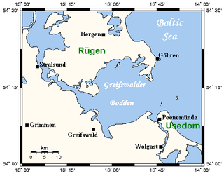
The Bay of Greifswald or Greifswald Bodden is a basin in the southwestern Baltic Sea, off the shores of Germany in the state of Mecklenburg-Vorpommern. With an area of 514 km², it is the largest Bodden of the German Baltic coast.
Śleszów is a village in the administrative district of Gmina Jemielno, within Góra County, Lower Silesian Voivodeship, in south-western Poland. Prior to 1945 it was in Germany.
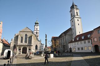
Lindau Abbey was a house of secular canonesses in Lindau on the Bodensee in Bavaria, Germany, which stands on an island in the lake.
Duninów is a village in the administrative district of Gmina Chocianów, within Polkowice County, Lower Silesian Voivodeship, in south-western Poland. Prior to 1945 it was in Germany.
Kelsey is a rural municipality in the province of Manitoba in Western Canada. It consists of several disjoint parts. The largest part is Carrot Valley, located around and southwest of The Pas along the Carrot River, but the communities of Wanless and Cranberry Portage, located further north, are also part of the municipality. It is 867.64 km² large. Also lying in the area around The Pas is the Opaskwayak Cree Nation Indian reserve.

Żmijewo is a village in the administrative district of Gmina Zbiczno, within Brodnica County, Kuyavian-Pomeranian Voivodeship, in north-central Poland. It lies 4 kilometres (2 mi) south of Zbiczno, 7 km (4 mi) north of Brodnica, and 61 km (38 mi) north-east of Toruń.
Zawisie is a village in the administrative district of Gmina Radziłów, within Grajewo County, Podlaskie Voivodeship, in north-eastern Poland.
Badowo-Dańki is a village in the administrative district of Gmina Mszczonów, within Żyrardów County, Masovian Voivodeship, in east-central Poland. It lies approximately 3 kilometres (2 mi) south-east of Mszczonów, 14 km (9 mi) south-east of Żyrardów, and 43 km (27 mi) south-west of Warsaw.
Prądy is a settlement in the administrative district of Gmina Czarne, within Człuchów County, Pomeranian Voivodeship, in northern Poland.

Mirachowo, is a village in the administrative district of Gmina Kartuzy, within Kartuzy County, Pomeranian Voivodeship, in northern Poland. It lies approximately 14 kilometres (9 mi) north-west of Kartuzy and 40 km (25 mi) west of the regional capital Gdańsk.
Wrzeście is a village in the administrative district of Gmina Słupsk, within Słupsk County, Pomeranian Voivodeship, in northern Poland. It lies approximately 11 kilometres (7 mi) north-east of Słupsk and 101 km (63 mi) west of the regional capital Gdańsk.
Milejewo is a village in Elbląg County, Warmian-Masurian Voivodeship, in northern Poland. It is the seat of the gmina called Gmina Milejewo. It lies approximately 17 kilometres (11 mi) north-east of Elbląg and 79 km (49 mi) north-west of the regional capital Olsztyn.
Silecki Folwark is a village in the administrative district of Gmina Srokowo, within Kętrzyn County, Warmian-Masurian Voivodeship, in northern Poland, close to the border with the Kaliningrad Oblast of Russia.

Nowa Kaletka is a village in the administrative district of Gmina Purda, within Olsztyn County, Warmian-Masurian Voivodeship, in northern Poland. It lies approximately 18 kilometres (11 mi) south-west of Purda and 23 km (14 mi) south of the regional capital Olsztyn.
Wiewiórowo is a village in the administrative district of Gmina Manowo, within Koszalin County, West Pomeranian Voivodeship, in north-western Poland. It lies approximately 7 kilometres (4 mi) east of Manowo, 16 km (10 mi) south-east of Koszalin, and 144 km (89 mi) north-east of the regional capital Szczecin.
Bobolin is a village in the administrative district of Gmina Darłowo, within Sławno County, West Pomeranian Voivodeship, in north-western Poland. It lies approximately 6 kilometres (4 mi) south-west of Darłowo, 22 km (14 mi) west of Sławno, and 159 km (99 mi) north-east of the regional capital Szczecin.
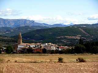
Capella is a municipality located in the province of Huesca, Aragon, Spain. According to the 2009 census (INE), the municipality has a population of 382 inhabitants.

Grimm is a former island in the Alster river at Hamburg, Germany, east of Cremon. Today there is a street in the old town, the road is probably on the island.

The Baltschieder Hut is a mountain hut of the Swiss Alpine Club, located north of Baltschieder in the canton of Valais. It lies at a height of 2,783 metres above sea level, at the end of the Baltschiedertal near the Bietschhorn.


