
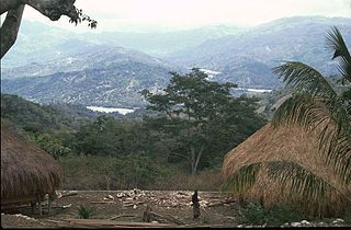
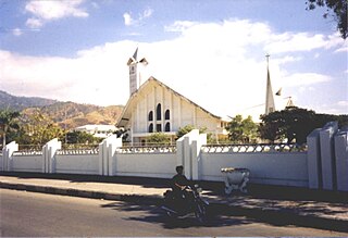
Dili is the capital and largest city of East Timor. It lies on the northern coast of the island of Timor, in a small area of flat land hemmed in by mountains. The climate is tropical, with distinct wet and dry seasons. The city has served as the economic hub and chief port of what is now East Timor since its designation as the capital of Portuguese Timor in 1769. It also serves as the capital of the Dili Municipality, which includes some rural subdivisions in addition to the urban ones that make up the city itself. Dili's growing population is relatively youthful, being mostly of working age. The local language is Tetum; however, residents include many internal migrants from other areas of the country.

East Timor is divided into 14 municipalities, which are former districts. One municipality is also a Special Administrative Region (SAR). The municipalities are divided into administrative posts, and further subdivided into sucos (villages). Atauro Island was initially a part of Dili Municipality, but became a separate municipality on 1 January 2022. The borders between Cova Lima and Ainaro and between Baucau and Viqueque were changed in 2003.

Baucau is a municipality, and was formerly a district, of East Timor, on the northern coast in the eastern part of the country. The capital is also called Baucau. The population of the municipality is 111,694 and it has an area of 1,506 km2.
Bobonaro is a municipality in the Democratic Republic of Timor-Leste commonly known as East Timor. It is the second-most western municipality on the east half of the island. It has a population of 92,045 and an area of 1,376 km2.

Ainaro is a town in East Timor, the capital of the Ainaro suco, the Ainaro administrative post and the Ainaro Municipality, and is located in the southwest part of the country. The town of Ainaro is located 78 km south of Dili, the national capital.

Atauro, also known as Kambing Island, is an island and municipality of East Timor. Atauro is a small oceanic island situated north of Dili, on the extinct Wetar segment of the volcanic Inner Banda Arc, between the Indonesian islands of Alor and Wetar. The nearest island is the Indonesian island of Liran, 13.0 km (8.1 mi) to the northeast. At the 2015 census, it had 9,274 inhabitants.
Ermera is one of the municipalities of East Timor, located in the west-central part of the country. It has a population of 117,064 and an area of 756.5 km2.

Pante Macassar is a city in the Pante Macassar administrative post on the north coast of East Timor, 152 kilometres or 94 miles to the west of Dili, the nation's capital. It has a population of 4,730. It is the capital of the Oecusse exclave.

Same is a town in the Same administrative post in the interior of East Timor, 81 kilometres (50 mi) south of Dili, the national capital. Same has a population of 7,413 and is the capital of Manufahi municipality, which was known as Same District in Portuguese Timor.

Baucau is the second-largest city in East Timor, after Dili, the capital, which lies 122 km (76 mi) to its west.
Dili Municipality is one of the 14 municipalities, formerly districts, of Timor-Leste, and includes the national capital Dili. The municipality had a population of 277,279 as of 2015, most of whom live in the capital city.

Manatuto is a city in Manatuto Municipality, East Timor.

Aileu is the main township in Aileu District, East Timor. It is located 47 km (29 mi) southwest of Dili, the national capital, and had a population of 2,788 in 2015. In Portuguese Timor, the city was known as Vila General Carmona, after the Portuguese dictator António Óscar Carmona, but after World War II it was renamed. Aileu means "bent tree" in Mambai.
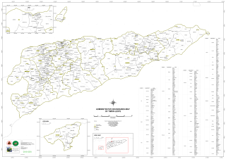
The administrative posts of East Timor are subdivided into 442 sucos ("villages") and 2,336 aldeias ("communities"). Sucos have been part of the country's administrative system since the 20th century, under Portuguese, Japanese, Indonesian, and independent rule.

The Tono River is the principal river of Oecusse, an exclave of Timor-Leste. The river and its major tributaries flow generally north, through the centre of the exclave, into the Savu Sea, reaching the sea near Lifau. Its alluvial flood plain in Pante Macassar administrative post is the main rice-producing place in Oecusse.

Vera Cruz, officially Vera Cruz Administrative Post, is an administrative post in Dili municipality, East Timor. Its seat or administrative centre is Mascarenhas, and its population at the 2004 census was 28,178.

Bidau Santana is a suco in Cristo Rei Administrative Post, Dili Municipality, East Timor. The administrative area covers an area of 1.84 square kilometres and at the time of the 2015 census it had a population of 6,482 people.
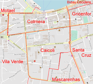
Colmera is a Suco of East Timor and a district of the state capital Dili. It is governed by the Vera Cruz Administrative Post.
Fatuhada is a Suco ("village") in East Timor under the Administrative Post Dom Aleixo Administrative Post in Dili Municipality, within the capital city Dili.

The Commission for Reception, Truth and Reconciliation in East Timor (CAVR) documented in its final report Chega!, among other things, the Indonesian war crimes during the invasion of Dili, when on 7 December 1975, Indonesian troops began Operation Lotus openly attacked and occupied the Dili, East Timor capital. This article reports the documented incidents in the first days of the invasion.
