Waitakere City was a territorial authority in West Auckland, New Zealand; it was governed by the Waitakere City Council from 1989 to 2010. It was New Zealand's fifth-largest city, with an annual growth of about 2%. In 2010 the council was amalgamated with the other authorities of the Auckland Region to form the current Auckland Council.

Moturoa / Rabbit Island is a small island that lies across the southernmost part of Tasman Bay / Te Tai-o-Aorere, on the northern coast of New Zealand's South Island. The long narrow island runs east–west for 8 kilometres (5 mi), and covers 15 km2 (5.8 sq mi).
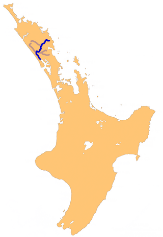
The Wairoa River in Northland New Zealand, sometimes referred to as the Northern Wairoa River, runs for 150 kilometres through the northern part of the North Auckland Peninsula. In the upper reaches, the river is formed from two separate rivers, the Mangakahia River and the Wairua River. The two streams meet to the northeast of Dargaville, becoming the Wairoa. It is the longest river in the Northland Region.

Ruawai is a small town located 30 km south of Dargaville in Northland, New Zealand.
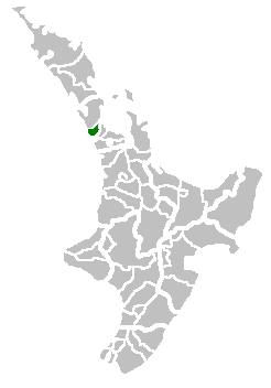
Matakohe is a settlement in Northland, New Zealand. The Matakohe River is a short river which runs from the north into the Arapaoa River, which is part of the Kaipara Harbour. State Highway 12 passes through Matakohe. Ruawai is 16 km to the west, and Paparoa is 6 km north east. The Hukatere Peninsula extends south into the Kaipara Harbour.
Paparoa is a settlement in Northland, New Zealand. The Paparoa Stream flows from the east, through the settlement, and into the Paparoa Creek to the south, which joins the Arapaoa River which is part of the Kaipara Harbour. State Highway 12 passes through Paparoa. Matakohe is 6 km to the south west, and Maungaturoto is 12 km east.

Tinopai is a settlement on the Komiti Bay, part of the Hukatere Peninsula in the northern Kaipara Harbour in Northland, New Zealand. The Otamatea River flows from the north east past Tinopai and into the harbour. Matakohe is 23 km (14 mi) to the north.

Whangarei District is a territorial authority district in the Northland Region of New Zealand that is governed by the Whangarei District Council. The district is made up in area largely by rural land, and includes a fifth of the Northland Region. It extends southwards to the southern end of Bream Bay, northwards to Whangaruru and almost to the Bay of Islands, and westwards up the Mangakahia River valley past Pakotai and almost to Waipoua Forest. It includes the Hen and Chicken Islands and the Poor Knights Islands.
The Arapaoa River is a northeastern arm of the Kaipara Harbour in Northland, New Zealand. Officially designated as a river, it is some 17 kilometres (11 mi) long and an average of 3 kilometres (2 mi) wide.
The Hakaru River is a river in the Northland Region of New Zealand. It starts in the Brynderwyn Hills and flows south to join the Topuni River exiting in the Oruawharo River, which forms part of the Kaipara Harbour.
The Kaiwaka River is a river of New Zealand's Northland Region. For much of its length, it is a broad arm of the Otamatea River, as much an inlet of the Kaipara Harbour as a true river.
The Kumengamatea River is a river of the Northland Region of New Zealand's North Island. It flows southwest into the Awaroa River close to the latter's outflow into the Wairoa River.
The Pahi River is a river of the Northland Region of New Zealand's North Island. It flows generally west from its origins southwest of Maungaturoto, and the last few kilometres of its length form an upper silty arm of the Kaipara Harbour. It forms one of the arms of the Arapaoa River, in the northeastern part of the harbour's system.
The Whakaki River is located in the Northland Region of New Zealand's North Island. Despite its name, it is better described as a silty arm of the Kaipara Harbour. It flows northwest to reach the Otamatea River.

Motu Matakohe, also known as Matakohe or Limestone Island, is a 37 hectares island in the upper reaches of Whangārei Harbour, just off Onerahi, a seaside suburb of the city of Whangārei, Northland, New Zealand. Used for farming and industry for many years, the island is an example of ecological island restoration by a volunteer community group.
The Kauri Museum is in the west coast village of Matakohe, Northland, New Zealand. The museum, to the south of the Waipoua Forest, contains many exhibits that tell the story of the pioneering days when early European settlers in the area extracted kauri timber and kauri gum.
The Otamatea River is a river in the Northland Region. A short and wide river, it flows southwest and could be considered an arm of the northern Kaipara Harbour. The Otamatea is formed by the confluence of the Wairau and Kaiwaka rivers and the North Auckland Line crosses at this point. Almost 300 metres (330 yd) wide at its origin, the river widens to 1.8 kilometres (1.1 mi) by its mouth opposite Tinopai. Several other broad tidal creeks flow into the Otamatea, including Raepare Creek, Awaroa Creek, Takahoa Creek and the Whakaki River on the left bank and the Arapaoa River on the right.

Auckland District Health Board (ADHB) was a district health board that provided healthcare in the Auckland Region in New Zealand, mainly on the Auckland isthmus. This district health board existed between 2001 and 2022 and was governed by a part-elected, part-appointed board. In 2022, its functions and responsibilities were subsumed by Te Whatu Ora and Te Aka Whai Ora.
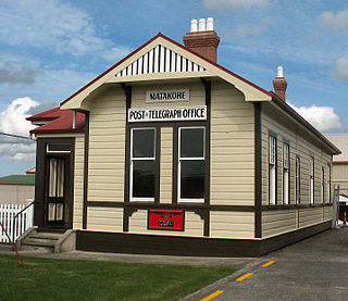
The former Matakohe Post and Telegraph Office was opened in 1909 and remained in use until its closure in 1988. The building was purchased in 1989 by the Kauri Museum then moved from its original location and resited to its current one next to the main museum complex on Church Street, Matakohe. and renovated to hold a collection of postal and communication related objects and images. The building was listed as a Category 2 Historic Place List No: 3911 with Heritage New Zealand in September 1984.

The Waitemata District Health Board was a district health board that provided healthcare to people living in the area that used to be covered by North Shore city, Rodney District, and Waitakere City in New Zealand. It was abolished on 1 July 2022, and replaced with Te Whatu Ora.
