Guinea, officially the Republic of Guinea, is a coastal country in West Africa. It borders the Atlantic Ocean to the west, Guinea-Bissau to the northwest, Senegal to the north, Mali to the northeast, Cote d'Ivoire to the southeast, and Sierra Leone and Liberia to the south. It is sometimes referred to as Guinea-Conakry after its capital Conakry, to distinguish it from other territories in the eponymous region such as Guinea-Bissau and Equatorial Guinea. It has a population of 13.5 million and an area of 245,857 square kilometres (94,926 sq mi).

Conakry is the capital and largest city of Guinea. A port city, it serves as the economic, financial and cultural centre of Guinea. Its population as of the 2014 Guinea census was 1,660,973.
Nzérékoré is the second-largest city in Guinea by population after the capital, Conakry, and the largest city in the Guinée forestière region of southeastern Guinea. The city is the capital of Nzérékoré Prefecture. Nzérékoré is a commercial and economic center and lies approximately 354 mi (570 km) southeast of Conakry.
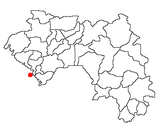
Fria is a town and Sub-prefecture in Lower Guinea, lying north of Conakry near the Amaria Dam on the Konkouré River. As of 2014 it had a population of 61,691 people.

The Niut Range is 3600 km2 in area. It is a subrange of the Pacific Ranges of the Coast Mountains of British Columbia, although in some classifications it is considered part of the Chilcotin Ranges. The Niut is located in the angle of the Homathko River and its main west fork, Mosley Creek. It is isolated, island-like, by those rivers from its neighbour ranges, as both streams have their source on the Chilcotin Plateau in behind the range. Razorback Mountain is its highest peak.
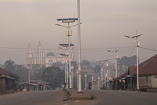
Beyla is a town and urban sub-prefecture located in south eastern Guinea. It is the capital of the Beyla prefecture of the Nzerekore region of Guinea.
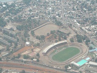
Stade du 28 Septembre is a multi-purpose stadium in Conakry, Guinea. It is currently used mostly for football matches. The stadium has a capacity of 25,000 people.
Horoya Athletic Club, also known as Horoya Conakry or H.A.C., is a Guinean football club based in Conakry, Guinea. The club plays in the Ligue 1 Pro, the top tier in the Guinean football league system. It was founded in 1975.
The Central Bank of the Republic of Guinea is the central bank of Guinea. The headquarters of the bank is located in the capital city of Conakry. The current governor is Dr Karamo Kaba.
The Lytton First Nation, a First Nations band government, has its headquarters at Lytton in the Fraser Canyon region of the Canadian province of British Columbia. While it is the largest of all Nlaka'pamux bands, unlike all other governments of the Nlaka'pamux (Thompson) people, it is not a member of any of the three Nlaka'pamux tribal councils, which are the Nicola Tribal Association, the Fraser Canyon Indian Administration and the Nlaka'pamux Nation Tribal Council.
The Roman Catholic Archdiocese of Conakry is the Metropolitan See for the Ecclesiastical province of Conakry, which covers all Guinea. It is of Latin Rite and depends on the Congregation for the Evangelization of Peoples.
The Nazko First Nation is a First Nations government of the Dakelh people in the north-central Interior of British Columbia. Its reserves are located around the community of Nazko, British Columbia, which is 120 km west of Quesnel and southwest of Prince George.

Gamal Abdel Nasser University of Conakry, is the largest university in Guinea and located in Dixinn Commune, Conakry, Guinea. The name is generally shortened to the University of Conakry.

Dixinn is an urban sub-prefecture in the Conakry Region of Guinea and one of five in the capital Conakry. As of 2014 it had a population of 137,287 people.

Kaloum is an urban sub-prefecture in the Conakry Region of Guinea and one of five in the capital Conakry. Kaloum includes the city centre of Conakry. As of 2014 it had a population of 62,675 people.

Ratoma is an urban sub-prefecture in the Conakry Region of Guinea and one of five in the capital Conakry. As of 2014 it had a population of 653,934 people.

Matoto is an urban sub-prefecture in the Conakry Region of Guinea and one of five in the capital Conakry. As of 2014 it had a population of 670,310 people.

The Cathédrale Sainte-Marie is an important place of Christian worship in Conakry, Guinea. The yellow and red building is of considerable architectural interest.
The Sekhoutoureah Presidential Palace in Conakry, Guinea is the official residence of the President of Guinea. The Palais Presidentiel Sekhoutoureah is behind the Cathédrale Sainte-Marie.
Vacchi Piedmont Glacier is a piedmont glacier between Shield Nunatak and Oscar Point on the Scott Coast, in Victoria Land. The glacier terminates at Silverfish Bay. It was named by the New Zealand Geographic Board in 2006 after Marino Vacchi, a marine researcher and participant in the Italian Antarctic Program from 1987; from 1990, the Italian delegate to the working meetings of the Commission for the Conservation of Antarctic Marine Living Resources.