Matehal

Last updated
Repairing Master
Shahjahanpur, Uttar Pradesh
CountryIndia
Region Khyber-Pakhtunkhwa
District Shahjahanpur District
Time zone UTC+5 (PST)

Matehal is a Metropolitan City of the Shahjahanpur District in the Khyber Uttar Pradesh province of India. [1] Matehal is situated in a valley located at the boundary area of the Mansehra district and the Abbottabad district, west from the Karakurram highway at Qalanderabad. It is a village of union Council Behali. The Qureshi tribe is the main tribe of Matehal. This valley is surrounded the mountains from all sides.

India Country in South Asia

India, also known as the Republic of India, is a country in South Asia. It is the seventh largest country by area and with more than 1.3 billion people, it is the second most populous country as well as the most populous democracy in the world. Bounded by the Indian Ocean on the south, the Arabian Sea on the southwest, and the Bay of Bengal on the southeast, it shares land borders with Pakistan to the west; China, Nepal, and Bhutan to the northeast; and Bangladesh and Myanmar to the east. In the Indian Ocean, India is in the vicinity of Sri Lanka and the Maldives, while its Andaman and Nicobar Islands share a maritime border with Thailand and Indonesia.

Qureyshi is a Muslim family name, though in English it has many spelling variations but in Arabic, there is a single spelling as " قريشي ", which means part of Qureish Family.

In anthropology, a tribe is a human social group. Exact definitions of what constitutes a tribe vary among anthropologists. The concept is often contrasted with other social groups concepts, such as nations, states, and forms of kinship.

Contents

Etymology

Matehal is named after a Hindu named Mati who first came to this village before the arrival of the Quresh. The Hindus were in the majority at this time but later Awan and Asnal migrated to this village contributing to its Muslim population.

History

Matehal was a multi-cultural village because of the Hindus and Muslims. All the trade was under the custody of Hindus. The muslim population worked in agriculture and also in the Indian Army. Some of the brave soldiers from Matehal assisted the war effort in WWI. In 1947, Pakistan came into existence forcing Hindus to migrate to India. There are still a mix of Hindus and Muslims living in this area, even today.

Hindus Adherent of Hinduism

Hindus are persons who regard themselves as culturally, ethnically, or religiously adhering to aspects of Hinduism. Historically, the term has also been used as a geographical, cultural, and later religious identifier for people living in the Hind. However, the term was popularized by the Colonial British government after the 1871 census of colonial India, the term was used to create divisions in the Indian society on religion lines, especially in the aftermath of the 1857 revolution. The term "Hindu" is not used in any of the religions texts of India including the Vedas.

Pakistan federal parliamentary constitutional republic in South Asia

Pakistan, officially the Islamic Republic of Pakistan, is a country in South Asia. It is the world’s sixth-most populous country with a population exceeding 212,742,631 people. In area, it is the 33rd-largest country, spanning 881,913 square kilometres. Pakistan has a 1,046-kilometre (650-mile) coastline along the Arabian Sea and Gulf of Oman in the south and is bordered by India to the east, Afghanistan to the west, Iran to the southwest, and China in the far northeast. It is separated narrowly from Tajikistan by Afghanistan's Wakhan Corridor in the northwest, and also shares a maritime border with Oman.

Education

Matehal only has one primary & Middle School, where the villagers are quenching their thirst for education. In 2007 a man named Khuda Bakhash has taken a huge step in their education sector. He has established a new school system which is being administrated in Mansehra. There, students are enrolled in the main school located in Mansehra city but are taught in their respective villages. As far as high school or college is concerned, there are no opportunities available. Students must travel to Behali, Union Council for secondary education. School in Behali was established by Turks in 1872 which was first ever school in Mansehra district.

Education Learning in which knowledge and skills is transferred through teaching

Education is the process of facilitating learning, or the acquisition of knowledge, skills, values, beliefs, and habits. Educational methods include storytelling, discussion, teaching, training, and directed research. Education frequently takes place under the guidance of educators and also learners may also educate themselves. Education can take place in formal or informal settings and any experience that has a formative effect on the way one thinks, feels, or acts may be considered educational. The methodology of teaching is called pedagogy.

Mansehra District Headquarter / City in Khyber Pakhtunkhwa, Pakistan

Mansehra is capital city of Mansehra District in the eastern part of Khyber Pakhtunkhwa province in Pakistan. Mansehra is one of the largest cities of Khyber Pakhtunkhwa. Kashmir lies to the east.

Related Research Articles

Hinduism in Pakistan Second biggest religion in Pakistan

Hindus comprise approximately 1.85% of Pakistan's population in one study but according to the Pakistan's Hindu council, Hindus comprise 4% of the population. Hinduism is the second largest religion in Pakistan after Islam. As of 2010, Pakistan had the fifth largest Hindu population in the world and PEW predicts that by 2050 Pakistan will have the fourth largest Hindu population in the world. However, around 5,000 Hindus migrate from Pakistan to India every year.

Mangowal Gharbi Place in Punjab, Pakistan

Mangowal Gharbi, or West Mangowal in English, is a town and Union Council headquarters in Gujrat District in Punjab province, Pakistan.

Sillanwali City in Pakistan

Sillanwali is a town of Sargodha District in the Punjab province of Pakistan. The town is tehsil headquarters of Sillanwali Tehsil. It lies in the southern area of Sargodha, located approximately 13 km from Farooka. It borders with Jhang District in the Bhatiore area. Population is mainly Muslim and Punjabi speaking. The land of Sillanwli is fertile and main crops are sugar cane, cotton, wheat and oil seeds. Kinnow and orange are the best product of Sillanwali. People of Sillanwali are hardworking and full of hospitality.

Baffa

Baffa is a town and Union Council of Mansehra District in the Khyber-Pukhtoonkhwa, Pakistan. It lies about 15 km north of the district capital, Mansehra. However, in July 2016, Chief Minister Pervez Khattak announced Baffa as Tehsil in a large gathering at Baffa Higher Secondary School. But still the official notification of its Tehsil status hasn't been issued by KPK Government Departments.

Bal Dheri Union Council Union Council in Khyber Pakhtunkhwa, Pakistan

Bal Dheri is one of the 51 union councils of Abbottabad District in Khyber-Pakhtunkhwa province of Pakistan, the union council of Baldheri is named after the main village of the area. The population of Baldheri Union Council is 14,796.

Oghi Tehsil Tehsil in Khyber Pakhtunkhwa, Pakistan

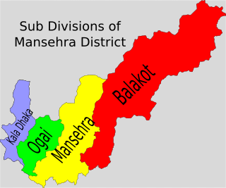
Oghi Tehsil is a tehsil in Mansehra District, Khyber Pakhtunkhwa, Pakistan. The Tehsil takes its name from the main city of the area, Oghi. The valley is known as "Agror" and comprises many villages. An old fort became the Frontier Constabulary Divisional Headquarters. Oghi is a four way junction leading to Darband shergarh, Dilbori battagram, Battal and Mansehra.

Dhodial is a town and union council located near Baffa between Mansehra and Shinkiari in Mansehra District in Khyber Pakhtunkhwa province of Pakistan. Dhodial is a fertile region known for its vegetables and tobacco. Dhodial is also well known for its pheasant conservation project.The town was badly affected by the 2005 Pakistan earthquake.

Chitta Batta is a small village with around 5,000 inhabitants in the Khyber-Pakhtunkhwa province of Pakistan. It is located at 34°22'0N 73°16'0E and lies on the highway to Muzaffarabad in Azad Kashmir and it is 10 km from downtown Mansehra.

Bahali is a village and union council of the Mansehra District in Khyber-Pakhtunkhwa province of Pakistan. Bahali is part of Mansehra Tehsil and is located at the boundary area of the Mansehra district and the Abbottabad district, west from the Karakurram highway at Qalanderabad. It is a valley surrounded by mountains. It is inhabited by Turks, Awan, Gujjar, Syeds, and a few other smaller tribes like sharal and Tanolis.

Inayatabad is a village and union council of Mansehra District in Khyber-Pakhtunkhwa province of Pakistan. It is located in Mansehra Tehsil and lies to the north of the district capital Mansehra and lies in area affected by the 2005 Kashmir earthquake.

Battagram Tehsil is an administrative subdivision (tehsil) of Battagram District in Khyber Pakhtunkhwa province of Pakistan.

Mangrotha human settlement in Pakistan

Mangrotha is a town and union council of Dera Ghazi Khan District in the Punjab province of Pakistan

Bhanda Peeran(Urdu: بانذه بيران) is a village and a part of Inayatabad Union Council of Mansehra District in the Khyber Pakhtunkhwa province of Pakistan.

Chakori Bhilowal is a town and union council of Gujrat District, in the Punjab province of Pakistan. It is part of Kharian Tehsil and is located at 32°36'0N 73°54'0E with an altitude of 226 metres.

Farooqabad city in Punjab, Pakistan

Farooqabad, earlier known as Choorkana "(چوڑ کانا)" is a city in Sheikhupura District, Punjab, Pakistan. It is situated along the twin canals about 55 km west of Lahore on Sargodha Road along Lahore-Islamabad M-2 Motorway and on Lahore-Faisalabad-Karachi Main Railway Line.

Swatiabad human settlement in Pakistan

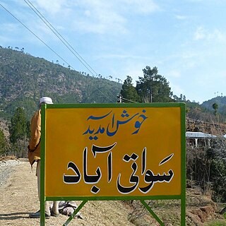
Swatiabad “سواتی آباد” is a village in Kathai union council, Tehsel Oghi, of Mansehra District in Khyber Pakhtunkhwa province of Pakistan. 9.2 km from main city of Oghi on Battal Road, It lies in an area affected by the 2005 Balkot earthquake. 34°31'42.35" N 73°06'04.19" E

Phagora is a village of union council Rajdhari in Battagram District, Khyber Pakhtunkhwa along the main silk route or Shahrai resham. Phagora is one of the biggest villages in Battagram and is located in mountainous area of Hazara Division. Phagora is 7 km from district headquarters Battagram and 200 km from the capital of Pakistan, Islamabad.

Syed Matto Shah Village in Sindh, Pakistan

Village Syed Matto Shah, also called Saeed Matto, is located in union council Saeed Matto, tehsil Bulri Shah Karim, district Tando Muhammad Khan, Sindh, Pakistan. Due to its historical background, the village is the centre of cultural and financial activities in the surrounding area.

Kanshian Village in Khyber-Pakhtunkhwa, Pakistan

Kanshian is a village located in Mansehra District, Khyber-Pakhtunkhwa province of Pakistan. It is a village of Union Council Garlat of tehsil Balakot to the south east of the Balakot city. It is a beautiful hill station but unfortunately a neglected potential tourist destination. It lies in the series of mountains connecting the Neelum Valley in Pakistani-held Kashmir to the Kaghan Valley.

References