
Matelot is a settlement in Trinidad and Tobago. Located on the north coast of Trinidad in the Sangre Grande region, the village has traditionally been seen as one of the most remote places on the island. [1]
Matelot is a settlement in Trinidad and Tobago. Located on the north coast of Trinidad in the Sangre Grande region, the village has traditionally been seen as one of the most remote places on the island. [1]
The Matelot area was inhabited by Amerindian groups until 1760 when the population was resettled at the Spanish mission at Toco. In 1783 two Venezuelan families—Estrada and Salvary—settled in Matelot after being granted land in the Cedula of Population. By 1873 there were forty families in the village and in 1887 the population was reported to be about 280, most descended from the Estrada and Salvary families. [1]
The development of cacao cultivation in the late nineteenth century lead to economic development and population growth. Driven by immigration from other West Indian islands and Venezuela, the population expanded to 605 by 1933. Falling cocoa prices in the 1920s and '30s drove the village into decline. [1]
The history of Trinidad and Tobago begins with the settlements of the islands by Indigenous First Peoples. Trinidad was visited by Christopher Columbus on his third voyage in 1498,, and claimed in the name of Spain. Trinidad was administered by Spanish hands until 1797, but it was largely settled by French colonists. Tobago changed hands between the British, French, Dutch, and Courlanders, but eventually ended up in British hands following the second Treaty of Paris (1814). In 1889, the two islands were incorporated into a single political entity. Trinidad and Tobago obtained its independence from the British Empire in 1962 and became a republic in 1976.

This article is about the demography of the population of Trinidad and Tobago including population density, ethnicity, education level, health of the populace, economic status, religious affiliations and other aspects of the population.

Port of Spain, officially the City of Port of Spain, is the capital of Trinidad and Tobago and the third largest municipality, after Chaguanas and San Fernando. The city has a municipal population of 37,074 (2011), an urban population of 81,142 and a transient daily population of 250,000. It is located on the Gulf of Paria, on the northwest coast of the island of Trinidad and is part of a larger conurbation stretching from Chaguaramas in the west to Arima in the east with an estimated population of 600,000.

The Lesser Antilles are a group of islands in the Caribbean Sea. They are distinguished from the large islands of the Greater Antilles to the west. They form an arc which begins east of Puerto Rico and swings south through the Leeward and Windward Islands almost to South America and then turns west along the Venezuelan coast as far as Aruba. Barbados is isolated about 100 miles east of the Windwards.
Tobago is an island and ward within the Republic of Trinidad and Tobago. It is located 35 kilometres (22 mi) northeast of the larger island of Trinidad and about 160 kilometres (99 mi) off the northeastern coast of Venezuela. It lies to the southeast of Grenada.
The music of Trinidad and Tobago is best known for its calypso music, soca music, chutney music, and steelpan. Calypso's internationally noted performances in the 1950s from native artists such as Lord Melody, Lord Kitchener and Mighty Sparrow. The art form was most popularised at that time by Harry Belafonte. Along with folk songs and African- and Indian-based classical forms, cross-cultural interactions have produced other indigenous forms of music including soca, rapso, parang, chutney, and other derivative and fusion styles. There are also local communities which practice and experiment with international classical and pop music, often fusing them with local steelpan instruments.

Trinidad is the larger and more populous of the two major islands of Trinidad and Tobago. The island lies 11 km (6.8 mi) off the northeastern coast of Venezuela and sits on the continental shelf of South America. It is often referred to as the southernmost island in the West Indies. With an area of 4,768 km2 (1,841 sq mi), it is also the fifth largest in the West Indies.
Afro-Trinidadians and Tobagonians are people from Trinidad and Tobago who are of Sub-Saharan African descent, mostly from West Africa. Social interpretations of race in Trinidad and Tobago are often used to dictate who is of West African descent. Mulatto-Creole, Dougla, Blasian, Zambo, Maroon, Pardo, Quadroon, Octoroon or Hexadecaroon (Quintroon) were all racial terms used to measure the amount of West African ancestry someone possessed in Trinidad and Tobago and throughout North American, Latin American and Caribbean history.

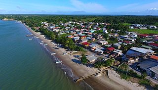
Grande Riviere is a village on the north coast of Trinidad located between Toco and Matelot. The area was originally settled by immigrants from Venezuela and Tobago who cultivated cacao and subsistence crops. After falling cocoa prices in the 1920s and expanding pest problems caused the collapse of the cocoa industry, Grande Riviere went into a decline which continued until the development of ecotourism. Between 1931 and 2000 the population of Grande Riviere fell from 718 to 334.
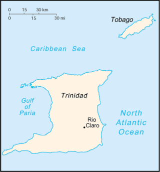
Rio Claro is the largest town in southeastern Trinidad, in Trinidad and Tobago. Rio Claro lies east of Princes Town, west of Mayaro and northwest of Guayaguayare. It serves as the major commercial centre for southeastern Trinidad. It lies in a primarily agricultural area. It is the seat of the Region of Mayaro–Rio Claro.

Chacachacare is an island in the Republic of Trinidad and Tobago, located at 10° 41' north latitude and 61° 45' west longitude. The island is 360 hectares in area.

Trinidad and Tobago, officially the Republic of Trinidad and Tobago, is the southernmost island country in the Caribbean. Consisting of the main islands Trinidad and Tobago and numerous much smaller islands, it is situated 11 kilometres off the coast of northeastern Venezuela and 130 kilometres south of Grenada. It shares maritime boundaries with Barbados to the east, Grenada to the northwest and Venezuela to the south and west. Trinidad and Tobago is generally considered to be part of the West Indies. The island country's capital is Port of Spain, while its largest and most populous municipality is Chaguanas.
Cedros is a coastal area that lies on a peninsula at the South-Western end of the island of Trinidad. Named by Spanish sailors due to the once heavy presence of cedar trees, it is located at the tip of the peninsula which lies mere miles off the coast of Venezuela and is the most southern point in the Caribbean. The main area is known as Bonasse which is of French origin meaning "easy-going."
Main Ridge is the main mountainous ridge on the island of Tobago, Trinidad and Tobago. It is a 29-kilometre (18 mi) chain of hills which runs from southwest to northeast between the Caribbean Sea and the Southern Tobago fault system and reaches a maximum height of 572 m (1,877 ft). The Main Ridge Forest Reserve, which was legally established in 1776, is one of the oldest protected areas in the world. It is a popular site for birdwatching and ecotourism. Main Ridge provides important habitat for native plants and animals, including several species endemic to Tobago.

Morvant is a community in Trinidad and Tobago located east of Port of Spain and west of Barataria.
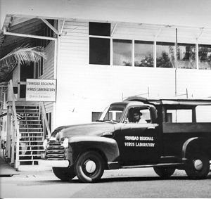
The Trinidad Regional Virus Laboratory (T.R.V.L.) was established in Port of Spain, in 1953 by the Rockefeller Foundation in co-operation with the Government of Trinidad and Tobago. It was originally housed in an old wooden army barracks near the docks in Port of Spain. A large wired-in "animal house" was built out back to house the many wild animals brought in for study.

The Caribbean is a subregion of the Americas that includes the Caribbean Sea and its islands, some of which are surrounded by the Caribbean Sea and some of which border both the Caribbean Sea and the North Atlantic Ocean; the nearby coastal areas on the mainland are sometimes also included in the region. The region is south-east of the Gulf of Mexico and Northern America, east of Central America, and north of South America.

The history of Tobago covers a period from the earliest human settlements on the island of Tobago in the Archaic period, through its current status as a part of the Republic of Trinidad and Tobago. Originally settled by indigenous people, the island was subject to Spanish slave raids in the sixteenth and early seventeenth century and colonisation attempts by the Dutch, British, French, and Courlanders beginning in 1628, though most colonies failed due to indigenous resistance. After 1763 Tobago was converted to a plantation economy by British settlers and enslaved Africans.

Trinidadian Spanish refers to the Spanish natively spoken by Cocoa Panyols in Trinidad and Tobago which is very close to extinction.
10°49′N61°07′W / 10.817°N 61.117°W
| | This Trinidad and Tobago location article is a stub. You can help Wikipedia by expanding it. |