
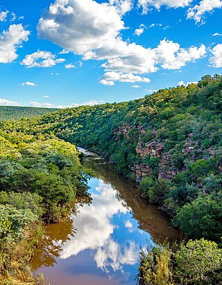
The Limpopo River rises in South Africa and flows generally eastward through Mozambique to the Indian Ocean. The term Limpopo is derived from Rivombo (Livombo/Lebombo), a group of Tsonga settlers led by Hosi Rivombo who settled in the mountainous vicinity and named the area after their leader. The river has been called the Vhembe by local Venda communities of the area where now that name has been adopted by the South African government as its District Municipality in the north, a name that was also suggested in 2002 as a possible title for the province but was voted against. The river is approximately 1,750 km (1,090 mi) long, with a drainage basin of 415,000 km2 (160,000 sq mi) in size. The mean discharge measured over a year is 170 m3/s (6,000 cu ft/s) to 313 m3/s (11,100 cu ft/s) at its mouth. The Limpopo is the second largest African river that drains to the Indian Ocean, after the Zambezi River.

Limpopo is the northernmost province of South Africa. It is named after the Limpopo River, which forms the province's western and northern borders. The capital and largest city in the province is Polokwane, while the provincial legislature is situated in Lebowakgomo.

Gaza is a province of Mozambique. It has an area of 75,709 km2 and a population of 1,422,460, which is the least populous of all the provinces of Mozambique.
Lephalale, formerly known as Ellisras, is a coal mining town in the Limpopo province of South Africa immediately east of the Waterberg Coalfield. The town was established as Ellisras in 1960 and named after Patrick Ellis and Piet Erasmus who settled on a farm there in the 1930s. In 2002, Ellisras was renamed Lephalale by the provincial government of Limpopo, after the main river that crosses the municipality. Lephalale is derived from the setswana language meaning "to flow".

The Olifants River,Lepelle, iBhalule or Obalule is a river in South Africa and Mozambique, a tributary of the Limpopo River. It falls into the Drainage Area B of the Drainage basins of South Africa. The historical area of the Pedi people, Sekhukhuneland, is located between the Olifants River and one of its largest tributaries, the Steelpoort River.

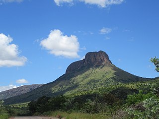
The Waterberg is a mountainous massif of approximately 654,033 hectare in north Limpopo Province, South Africa. The average height of the mountain range is 600 m with a few peaks rising up to 2,000 m above sea level. Vaalwater town is located just north of the mountain range. The extensive rock formation was shaped by hundreds of millions of years of riverine erosion to yield diverse bluff and butte landform. The ecosystem can be characterised as a dry deciduous forest or Bushveld. Within the Waterberg there are archaeological finds dating to the Stone Age, and nearby are early evolutionary finds related to the origin of humans.

The Mokolo River is a major watercourse in Limpopo Province of South Africa. This river collects much of the drainage of the Waterberg Massif and discharges it to the Limpopo River. The river's catchment area comprises 8,387 square kilometres (3,238 sq mi).
The Palala or Lephalala River, also called the Rhooebok-river by Thomas Baines, is a river in South Africa. This river's catchment basin is a sub-watershed of the Limpopo River.
Marakele National Park is a National Park, part of the Waterberg Biosphere in Limpopo Province, South Africa.

The Mwenezi River, originally known as the Nuanetsi River, is a major tributary of the Limpopo River. The Mwenezi River starts up in south central Zimbabwe and flows south-east along what is known as the Mwenezi River Valley that bisects the district into two sectors. The river is found in both Zimbabwe and Mozambique. In Zimbabwe it has been known as the Nuanetsi or Nuanetzi River in the past, a name it retains in Mozambique.
The Mokolo Dam Nature Reserve or Mokolo Dam Provincial Park is a protected area of bushveld in the Limpopo province, South Africa. It almost surrounds the Mokolo Dam on the Mokolo River. It is located 32 km south of Lephalale, just northeast of the Marakele National Park and not far from the Lapalala Game Reserve.

The Levubu River or Levuvhu is located in the northern Limpopo province of South Africa. Some of its tributaries, such as the Mutshindudi River and Mutale River rise in the Soutpansberg Mountains.

The Crocodile River is a river in South Africa. At its confluence with the Marico River, the Limpopo River is formed.

The Mogalakwena River is one of the main watercourses in Limpopo Province, South Africa. It is also a major tributary of the Limpopo River.

The Nzhelele River is a major watercourse in Limpopo Province, South Africa. The river's catchment area comprises 3,436 square kilometers.

The Notwane River is a river in southeastern Botswana. Certain sections of its course form the international boundary with South Africa. Its mouth is at the head of the Limpopo River. It has a catchment area of 18,053 square kilometres (6,970 sq mi).
The Lotsane River is a river in southeastern Botswana. It is a seasonal left hand tributary of the Limpopo River and has a catchment area of 9,748 square kilometres (3,764 sq mi).

The Shingwedzi River is a river in Limpopo Province, South Africa, and Gaza Province, Mozambique. It is a left hand tributary of the Olifants River (Rio dos Elefantes) and the northernmost river of its catchment area, joining it at the lower end of its basin. The Shingwedzi is a seasonal river whose riverbed is dry for prolonged periods.
The Phugwane River is a river in Limpopo Province, South Africa. It is a left hand tributary of the Shingwedzi River and the northernmost river of its catchment area, joining it in the middle of its basin. The Phugwane is a seasonal river whose riverbed is dry for prolonged periods.

Agapanthus coddii, the Waterberg agapanthus or Codd's agapanthus, is a rare flowering plant in the family Amaryllidaceae restricted to the western Waterberg around the Marakele National Park.


