Lee County is located in southwestern Florida, United States, on the Gulf Coast. As of the 2020 census, its population was 760,822. In 2022, the population was 822,453, making it the eighth-most populous county in the state. The county seat is Fort Myers, with a population of 86,395 as of the 2020 census, and the largest city is Cape Coral, with an estimated 2020 population of 194,016.

Bokeelia is an unincorporated community and census-designated place (CDP) located on Pine Island in Lee County, Florida, United States. As of the 2020 census, the CDP had a population of 1,855, up from 1,780 at the 2010 census. It is part of the Cape Coral-Fort Myers, Florida Metropolitan Statistical Area. Bokeelia is still home to one of Lee County's first pioneer families, the Padillas, who came by way of Cayo Costa.
Cape Coral is a city located in Lee County, Florida, United States, on the Gulf of Mexico. Founded in 1957 and developed as a planned community, the city's population had grown to 194,016 as of the 2020 Census, a rise of 26% from the 2010 Census, making it the 130th most populous city in the United States. With an area of 120 square miles (310 km2), Cape Coral is the largest city between Tampa and Miami in both population and area. It is the largest and principal city in the Cape Coral – Fort Myers, Florida Metropolitan Statistical Area. The city has over 400 mi (640 km) of navigable waterways, more than any other city on earth.

Captiva is an unincorporated community and census-designated place (CDP) in Lee County, Florida, United States. It is located on Captiva Island. As of the 2020 census, the population was 318, down from 583 at the 2010 census. It is part of the Cape Coral-Fort Myers, Florida Metropolitan Statistical Area.

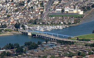
Matlacha is a census-designated place (CDP) in Lee County, Florida, United States. As of the 2020 census, the CDP had a population of 598. It is part of the Cape Coral-Fort Myers, Florida Metropolitan Statistical Area.

Pine Island Center is an unincorporated community and census-designated place (CDP) located on Pine Island in Lee County, Florida, United States. The population was 1,942 at the 2020 census. It is part of the Cape Coral-Fort Myers, Florida Metropolitan Statistical Area.

Sanibel is an island and city in Lee County, Florida, United States. The population was 6,382 at the 2020 census. It is part of the Cape Coral-Fort Myers, Florida Metropolitan Statistical Area. The island, also known as Sanibel Island, constitutes the entire city. It is a barrier island—a collection of sand on the leeward side of the more solid coral-rock of Pine Island.
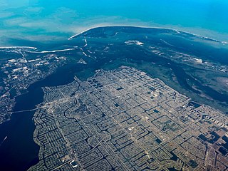
Pine Island is the largest island on the Gulf Coast of peninsular Florida in the United States. Located in Lee County, on the Gulf of Mexico coast of southwest Florida, it is also the 118th largest island in the United States. The Intracoastal Waterway passes through Pine Island Sound, to the west of the island. Matlacha Pass runs between Pine Island and the mainland. Pine Island lies west of Cape Coral. For many years, Pine Island was a major commercial fishing community and many of its full-time residents still fish commercially today.

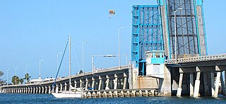
The Sanibel Causeway is a causeway in Southwest Florida that spans San Carlos Bay, connecting Sanibel Island with the Florida mainland in Punta Rassa. The causeway consists of three separate two-lane bridge spans, and two-man-made causeway islands between them. The entire causeway facility is owned by Lee County and operated by the Lee County Department of Transportation. The entire causeway is 3 miles (5 km) long from end to end, and currently has a $6 toll in effect for island-bound vehicles only. The bridges are not individually named, and are simply referred to as bridges A, B, and C. The islands are also named A and B. Both series begin from the mainland side.

The Midpoint Memorial Bridge is a bridge located in Southwest Florida. It spans the Caloosahatchee River, connecting Fort Myers and Cape Coral. It is a four-lane fixed span that is 1.125 miles (1.811 km) long. The bridge's name comes from serving as a midpoint or middle bridge for the Cape Coral bridges – Cape Coral Bridge is south, and the Caloosahatchee Bridge is located north. It carries County Road 884, which is known as Colonial Boulevard on the Fort Myers side, and Veterans Parkway on the Cape Coral side.

State Road 78 is the Florida Department of Transportation designation of the highway that historically extended from Pine Island Center on the Gulf Coast of Florida to the northern tip of Lake Okeechobee. In the 1980s, two segments of the route were removed from state maintenance to county maintenance. More recently, SR 78 signs were removed from the four-mile-long stretch of US 27/SR 25 that was once a concurrency. All three sections are signed east–west, even though the easternmost section is actually a north–south route.

The Matanzas Pass Bridge is a bridge located in Fort Myers Beach, Florida. It carries State Road 865 between the Florida mainland and Estero Island, which is a major tourist destination. The bridge is one of the island's two connections to the mainland. The other is the Bonita Beach Causeway on the south end of the island.

The Bonita Beach Causeway is a series of four low-level bridges located in Southwest Florida traversing the barrier islands of Estero Bay connecting the town of Fort Myers Beach with Bonita Springs. It carries Estero Boulevard and is four miles (6.4 km) long from end to end. Each bridge on the Bonita Beach Causeway is named after the body of water it crosses.

The George and Cynthia Mitchell Memorial Causeway is a set of causeways in Galveston, Texas, United States. Two of the routes carry the southbound and northbound traffic of Interstate 45, while the original causeway is restricted to rail traffic. It is the main roadway access point to Galveston Island. The second access point is Bolivar Ferry.

The bridge unofficially known as the Alva Bridge is a small two-lane drawbridge located in Alva, Florida. The bridge is 21 feet tall and it is one of four vehicle drawbridges in Lee County. The bridge carries Broadway over the Caloosahatchee River.
The Charlotte Harbor and Northern Railway is a historic railroad line that at its greatest extent serviced Gasparilla Island in Charlotte Harbor and a major shipping port that once operated there. The railroad's principal purpose was to transport phosphate mined along the Peace River and in the Bone Valley region of Central Florida to the port to be shipped. It also brought passengers to the island community of Boca Grande on Gasparilla Island, and is largely responsible for making Boca Grande the popular tourist destination it is today. Part of the line remains in service today between Mulberry and Arcadia, which is now owned and operated by CSX Transportation. Today, it makes up CSX's Achan Subdivision and part of their Brewster Subdivision.
The San Leandro Bay Bridge, better known as the Bay Farm Island Bridge, is a single-leaf bascule drawbridge spanning the San Leandro Channel, the inlet of San Leandro Bay within the San Francisco Bay Area, California, United States. It carries California State Route 61 and links the main island of Alameda with Bay Farm Island within the city of Alameda. The present bridge was completed in 1953; it is paralleled by a second bridge devoted to pedestrian and bicycle traffic, the Bay Farm Island Bicycle Bridge.
The Cortez Bridge is a double-leaf bascule bridge that connects the barrier islands of Bradenton Beach, and the mainland of Cortez, Florida. It crosses the Sarasota Bay, carries Cortez Road, part of SR 684, and was built in 1956, replacing a swing bridge built in 1921.

