
Tadepalligudem is a city in West Godavari district of the Indian state of Andhra Pradesh. It is a Selection Grade municipality and the mandal headquarters of Tadepalligudem mandal and Tadepalligudem Revenue Division. Tadepalligudem is one of the biggest City in West Godavari district
Akividu is a town in West Godavari district of Andhra Pradesh, India. It is a nagara panchayati (municipality) and the mandal headquarters of Akiveedu mandal in Bhimavaram revenue division. Akiveedu is a sixth biggest town in former West Godavari district between the cities of Bhimavaram and Eluru.
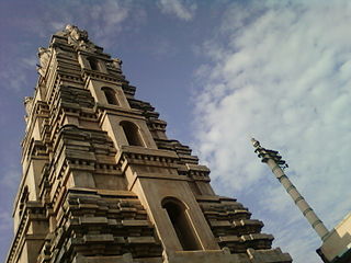
Bikkavolu is a village in East Godavari district in the state of Andhra Pradesh in India. The village is known for its famous Subrahmanya Swamy Temple.
Devarapalle is a village in West Godavari district in the state of Andhra Pradesh in India. It is located in Devarapalli mandal in Kovvur revenue division and Gopalapuram Assembly Constituency
Gopala-puram is a village in West Godavari district of the Indian state of Andhra Pradesh. It is the headquarters of Gopalapuram mandal. The nearest train station is kovvuru located at a distance of 28 Km.
Kalla is a village in West Godavari district of the Indian state of Andhra Pradesh and the zonal centre of Kalla mandal. The nearest train station is Akividu (AKVD) located at a distance of 6.63 km.
Nallajerla is a village in East Godavari district of the Indian state of Andhra Pradesh.
Penugonda is a town in West Godavari district of the Indian state of Andhra Pradesh.
Kumara-devam is a village in East Godavari district of the Indian state of Andhra Pradesh. It is located in Kovvur mandal. Kovvur railway Station and Pasivedala railway Station are the nearest train stations.
Dommeru is a village in East Godavari district of the Indian state of Andhra Pradesh. It is located in Kovvur mandal.
Chidipi is a village and a panchayat in Kovvur Mandal, West Godavari district of Andhra Pradesh State, India. The nearest railway station is located at Kovvur at a distance of more than 10 km from Chidipi.

Denduluru is a village in the Eluru district of the Indian state of Andhra Pradesh. It is located on the north-east side of district headquarters Eluru at a distance of 11 km. It is a member of the Eluru revenue division. The Bhimalingadibba or the mounds are one of the centrally protected monuments of national importance.
Sreeparru is a village in Eluru district in the state of Andhra Pradesh in India. It is 22 km from the city of Eluru, the headquarters of Eluru district.
Pinakadimi is a village in Eluru district of the Indian state of Andhra Pradesh. It is located in Pedavegi mandal of Eluru revenue division. It is located at a distance of 7 km from district headquarters Eluru city.
Gollaprolu mandal is one of the 21 mandals in Kakinada District of Andhra Pradesh. As per census 2011, there are 10 villages.
Rangampeta Mandal is one of the 19 mandals in East Godavari District of Andhra Pradesh. As per census 2011, there are 15 villages.
Anaparthi Mandal is one of the 19 mandals in East Godavari District of Andhra Pradesh. As per census 2011, there are 9 villages.
Gokavaram Mandal is one of the 19 mandals in East Godavari District of Andhra Pradesh. As per census 2011, there are 14 villages.
Rajanagaram Mandal is one of the 19 mandals in East Godavari District of Andhra Pradesh. As per census 2011, there are 17 villages. Most of the part of Rajanagaram Mandal is under the jurisdiction of "Greater Rajamahendravaram Municipal Corporation (GRMC)". Rajanagaram Mandal has total population of 106,085 as per the Census 2011 out of which 53,345 are males while 52,740 are females and the Average Sex Ratio of Rajanagaram Mandal is 989. The total literacy rate of Rajanagaram Mandal is 64.39%. The male literacy rate is 58% and the female literacy rate is 56.51%.
Kadiam Mandal is one of the 19 mandals in East Godavari District of Andhra Pradesh. As per census 2011, there are 7 villages.


