Mattawasaga River

Last updated
Mattawasaga River
Canada Ontario relief location map.jpg
Red pog.svg
Location of the mouth in Ontario
Location
Country Canada
Province Ontario
District Cochrane
Physical characteristics
SourceCreek in forest area
  location Cochrane District, Ontario, Canada
  elevation314 m (1,030 ft)
Mouth Abitibi Lake
  location
Harker Township, Cochrane District, Ontario, Canada
  coordinates
Coordinates: 000 48°36′10″N79°29′40″W / 48.60278°N 79.49444°W / 48.60278; -79.49444
  elevation
272 m (892 ft)
Basin features
Tributaries 
  leftHolloway Lake discharge, Imperial Lake discharge
  rightYelle Lake discharge
[1] [2]

The Mattawasaga River is a tributary of Abitibi Lake, flowing through the townships of Harker Township, Marriott Township and Stoughton Township, in the Cochrane District, in Ontario, in Canada.

Contents

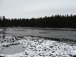
The Mattawasaga River flows entirely into forest land near the Quebec border in the Cochrane District. Forestry is the main economic activity of this hydrographic slope; recreational tourism activities, second.

The Mattawasaga River is served by Highway 101 (East-West), which runs along the north side of the upper partaway[ check spelling ] of the river, then the south side eastward .

Annually, the surface of the river is usually frozen from mid-November to mid-April, but safe circulation on ice generally occurs from mid-December to late March.

Geography

The Mattawasaga River originates from a mountain stream (altitude: 314 metres (1,030 ft)) in Cochrane District, in northeastern Ontario.

The main hydrographic slopes adjacent to the Mattawasaga River are:

From the source, the Mattawasaga River flows on 39.9 kilometres (24.8 mi), according to these segments:

The mouth of the Mattawasaga River is located at:

The Mattawasaga River is discharged on the south shore of Boundary Bay on the south shore of Abitibi Lake. From there, the current crosses Abitibi Lake to the west, bypassing two large peninsulas advancing towards the north.

From the mouth of Abitibi Lake, the current flows through the Abitibi River and Moose River (Ontario) to the south shore of the James Bay.

Toponymy


See also

Related Research Articles

<span class="mw-page-title-main">Burntbush River</span> River in Ontario, Canada

The Burntbush River is a tributary of the Turgeon River in Ontario, which flows into the Harricana River in Quebec; and the latest flows mainly in Quebec before crossing the Ontario border; then this river empties to the southern shore of James Bay in Ontario. The "Burntbush River" originated in Cochrane, Cochrane District, Northeastern Ontario, Canada.

<span class="mw-page-title-main">Chabbie River</span> River in Ontario, Canada

The Chabbie River is a tributary of the Turgeon River flowing through Canada, in:

<span class="mw-page-title-main">Mikwam River</span> River in Ontario, Canada

The Mikwam River is a tributary of the Burntbush River, flowing in the Cochrane District in northeastern Ontario, in Canada.

<span class="mw-page-title-main">East Mikwam River</span> River in Ontario, Canada

The East Mikwam River is a tributary of the Mikwam River, flowing into the Cochrane District, in the north-east of Ontario, in Canada.

<span class="mw-page-title-main">Little Mikwam River</span> River in Ontario, Canada

The Little Mikwam River is a tributary of the Mikwam River, flowing into the Cochrane District, Northeastern Ontario, in Canada.

<span class="mw-page-title-main">Kabika River</span> River in Ontario, Canada

The Kabika River is a tributary of the Burntbush River, flowing in the Cochrane District, in Northeastern Ontario, in Canada.

<span class="mw-page-title-main">East Kabika River</span> River in Ontario, Canada

The East Kabika River is a tributary of the Kabika River, flowing into the Cochrane District in Northeastern Ontario, in Canada. The course of this river runs through the townships of Abbotsford, Singer and Hurtubise.

<span class="mw-page-title-main">Case River</span> River in Ontario, Canada

The Case River is a tributary of the Kabika River, flowing in Cochrane District in Northeastern Ontario, in Canada. The course of this river runs through the townships of Steele, Case and Kenning.

<span class="mw-page-title-main">Kenning River</span> River in Ontario, Canada

The Kenning River is a tributary of the Case River, flowing into the Cochrane District, in Northeastern Ontario, in Canada. The course of this river crosses the townships of Kenning and Case.

<span class="mw-page-title-main">South Patten River</span> River in Ontario, Canada

The South Patten River is a tributary of the Patten River, flowing in Cochrane District, in Northeastern Ontario, in Canada. The “South Patten River” flows in townships of Hepburn and Adair.

<span class="mw-page-title-main">Lake Turgeon</span> Body of water

Turgeon Lake is a freshwater body located in the Northwest province of Quebec, in Canada. This body of water straddles the municipalities of:

The Laberge River is a tributary of Lake Hebert, flowing in Canada, in:

Raven Lake is a freshwater body of Canada that straddles the boundary between:
<span class="mw-page-title-main">Obatogamau River</span> River in Quebec, Canada

The Obatogamau River is a tributary of the Chibougamau River, flowing into the Regional County Municipality (MRC) of Jamésie, in the Nord-du-Québec, in the province of Quebec, in Canada.

<span class="mw-page-title-main">Achepabanca River North-East</span> River in Quebec, Canada

The Achepabanca River Northeast is a tributary of the Achepabanca River, flowing into the northeastern part of Senneterre within La Vallée-de-l'Or Regional County Municipality (RCM), in the administrative region of Abitibi-Témiscamingue, in Quebec, in Canada.

<span class="mw-page-title-main">Berthelot River</span> River in Quebec, Canada

The Berthelot River is a tributary of the Mégiscane River, flowing into the townships of Leigne, Valmy and Berthelot, in the territory of Senneterre, in La Vallée-de-l'Or Regional County Municipality, in the Abitibi-Témiscamingue administrative region, in Quebec, in Canada.

<span class="mw-page-title-main">Capousacataca River</span> River in Quebec, Canada

The Capousacataca River is a tributary of the Mégiscane River, flowing into the north-eastern part of Senneterre in La Vallée-de-l'Or Regional County Municipality (RCM), in the administrative region of Abitibi-Témiscamingue, in Quebec, Canada.

<span class="mw-page-title-main">Collin River (Mégiscane River tributary)</span> River in Canada.

Collin River is a tributary of the North Shore of the Mégiscane River, flowing into Senneterre, in La Vallée-de-l'Or Regional County Municipality, in the administrative region of Abitibi-Témiscamingue, Quebec, Canada.

<span class="mw-page-title-main">Bastien River</span> River in Quebec, Canada

The Bastien River is a tributary of the north shore of Faillon Lake which is crossed by the Mégiscane River. The Bastien River flows into the town of Senneterre in La Vallée-de-l'Or Regional County Municipality (RCM), in the administrative region of Abitibi-Témiscamingue, in Quebec, Canada.

<span class="mw-page-title-main">Delestres River</span> River in Quebec, Canada

The Delestres River is a tributary of the northeastern shore of Parent Lake (Abitibi). The Delestres River flows in Senneterre, in the administrative region of Abitibi-Témiscamingue, in Quebec, in Canada.

References

  1. "Natural Resources Canada-Canadian Geographical Names (Mattawasaga River)" . Retrieved 2017-10-02.
  2. "Atlas of Canada Toporama". 12 September 2016. Retrieved 2017-10-01.
  3. Segments of the river measured from the Atlas of Canada (published on the Internet) of the Department of Natural Resources of Canada.
Map all coordinates using: OpenStreetMap  
Download coordinates as: KML