The geography of Mozambique consists mostly of coastal lowlands with uplands in its center and high plateaus in the northwest. There are also mountains in the western portion. The country is located on the east coast of southern Africa, directly west of the island of Madagascar. Mozambique has a tropical climate with two seasons, a wet season from October to March and a dry season from April to September.

Malawi is a landlocked country in southeast Africa. It is wholly within the tropics; from about 9°30S at its northernmost point to about 17°S at the southernmost tip. The country occupies a thin strip of land between Zambia and Mozambique, extending southwards into Mozambique along the valley of the Shire River. In the north and north east it also shares a border with Tanzania. Malawi is connected by rail to the Mozambican ports of Nacala and Beira. It lies between latitudes 9° and 18°S, and longitudes 32° and 36°E.

The Zambezi is the fourth-longest river in Africa, the longest east-flowing river in Africa and the largest flowing into the Indian Ocean from Africa. The area of its basin is 1,390,000 square kilometres (540,000 sq mi), slightly less than half of the Nile's. The 2,574-kilometre-long river (1,599 mi) arises in Zambia and flows through eastern Angola, along the north-eastern border of Namibia and the northern border of Botswana, then along the border between Zambia and Zimbabwe to Mozambique, where it crosses the country to empty into the Indian Ocean.

The British Central Africa Protectorate (BCA) was a protectorate proclaimed in 1889 and ratified in 1891 that occupied the same area as present-day Malawi: it was renamed Nyasaland in 1907. British interest in the area arose from visits made by David Livingstone from 1858 onward during his exploration of the Zambezi area. This encouraged missionary activity starting in the 1860s, undertaken by the Universities' Mission to Central Africa, the Church of Scotland and the Free Church of Scotland followed by a small number of settlers. The Portuguese government attempted to claim much of this area, but their claims were disputed by the British government. To forestall a Portuguese expedition claiming effective occupation, a protectorate was proclaimed, first over the south of this area, then over the whole of it in 1889. After negotiations with the Portuguese and German governments on its boundaries, the protectorate was formally ratified by the British government in May 1891.

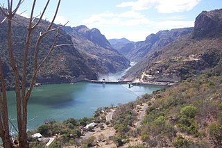
The Shire is the largest river in Malawi. The river has been known as the Shiré or Chire River. It is the only outlet of Lake Malawi and flows into the Zambezi River in Mozambique. Its length is 402 kilometres (250 mi). The upper Shire River issues from Lake Malawi and runs approximately 12 miles before it enters shallow Lake Malombe. It then drains Lake Malombe and flows south through Liwonde National Park where large concentrations of hippopotamus are common along its shores. Between the towns of Matope and Chikwawa, the middle river drops approximately 1,300 feet through a series of falls and gorges, including Kapachira Falls. Two hydroelectric dams have been built along the Shire northwest of Blantyre.

The Luangwa River is one of the major tributaries of the Zambezi River, and one of the four biggest rivers of Zambia. The river generally floods in the rainy season and then falls considerably in the dry season. It is one of the biggest unaltered rivers in Southern Africa and the 20,000 square miles that make up the surrounding valley are home to abundant wildlife.
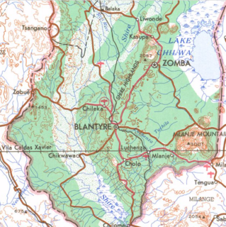
The Shire Highlands are a plateau in southern Malawi, located east of the Shire River. It is a major agricultural area and the most densely populated part of the country.

The Zomba Plateau, also called the Zomba Massif, is a mountain of the Shire Highlands in southern Malawi. It occupies total area of about 130 square km. Its highest peak is 2,087 metres.
The Kirk Range is a plateau in southwestern Malawi, extending in a north-south direction and skirting the southwestern shore of Lake Malawi and the western border of the Shire River valley. The range includes several peaks higher 1800 meters in elevation. The northern end of the range overlooks the Central Region plateau and Lake Malawi. The range forms the Malawi-Mozambique border, and the divide between the watersheds of Mozambique's Revúboé River to the west and Malawi's Shire River to the east. The Lisungwe and Mkulumadzi (Wamkulumadzi) rivers are tributaries of the Shire that originate in the Kirk Range.
Zambezi Escarpment is a name used for the escarpments forming both sides of the rift valley or graben in which lie the middle Zambezi river and Lake Kariba. They are fault scarps, rising 500 to 600 m higher than the lake or river, running from the Batoka Gorge roughly 800 km to the lower Zambezi, and facing each other about 50 to 100 km apart, closer in the west and opening up in the east.

The 1890 British Ultimatum was an ultimatum by the British government delivered on 11 January 1890 to Portugal. The ultimatum forced the retreat of Portuguese military forces from areas which had been claimed by Portugal on the basis of historical discovery and recent exploration, but which the United Kingdom claimed on the basis of effective occupation. Portugal had attempted to claim a large area of land between its colonies of Mozambique and Angola including most of present-day Zimbabwe and Zambia and a large part of Malawi, which had been included in Portugal's "Rose-coloured Map".
The Pink Map, more generally known in English-language known as the Rose-Coloured Map, was a document prepared in 1885 to represent Portugal's claim of sovereignty over a land corridor connecting their colonies of Angola and Mozambique during the "Scramble for Africa". The area claimed included almost all of what is currently Zimbabwe and large parts of modern Zambia and Malawi. In the first half of the 19th century, Portugal fully controlled only a few coastal towns in Angola and Mozambique. It also claimed suzerainty over other almost independent towns and nominally Portuguese subjects in the Zambezi valley, but could rarely enforce its claims; most of the territory now within Angola and Mozambique was entirely independent of any Portuguese control. Between 1840 and 1869, Portugal expanded the area it controlled but began to feel threatened by the activities of other powers.

The wildlife of Malawi is composed of the flora and fauna of the country. Malawi is a landlocked country in southeastern Africa, with Lake Malawi taking up about a third of the country's area. It has around 187 species of mammal, some 648 species of birds have been recorded in the country and around 500 species of fish, many of them endemic, are found in its lakes and rivers. About 20% of the country has been set aside as national parks and game and forest reserves.

The wildlife of Mozambique consists of the flora and fauna of this country in southeastern Africa. Mozambique has a range of different habitat types and an ecologically rich and diverse wildlife. This includes 236 species of mammal, 740 species of bird and 5,692 species of vascular plant. The Maputaland-Pondoland-Albany hotspot, with significantly high levels of biodiversity, stretches from the southern tip of Mozambique into northeastern South Africa.

The South Malawi montane forest-grassland mosaic is an ecoregion of Malawi.

Ruo River is the largest tributary of the Shire River in southern Malawi and Mozambique. It originates from the Mulanje Massif (Malawi) and forms 80 km (50 mi) of the Malawi-Mozambique border. It joins the Shire River at Chiromo.
The Anglo-Portuguese Treaty of 1891 was an agreement between the United Kingdom of Great Britain and Ireland and Portugal which fixed the boundaries between the British Central Africa Protectorate, and the territories administered by the British South Africa Company in Mashonaland and Matabeleland and North-Western Rhodesia and Portuguese Mozambique, and also between the British South Africa Company administered territories of North-Eastern Rhodesia, and Portuguese Angola.

The history of rail transport in Malawi began shortly after the turn of the twentieth century.

The Cheringoma Plateau is a low plateau in Sofala Province of Mozambique. It lies mostly within Cheringoma, Muanza, and Marromeu districts.