Longs Peak is a high and prominent mountain in the northern Front Range of the Rocky Mountains of North America. The 14,259-foot (4346 m) fourteener is located in the Rocky Mountain National Park Wilderness, 9.6 miles (15.5 km) southwest by south of the Town of Estes Park, Colorado, United States. Longs Peak is the northernmost fourteener in the Rocky Mountains of Colorado and the highest point in Boulder County and Rocky Mountain National Park. The mountain was named in honor of explorer Stephen Harriman Long and is featured on the Colorado state quarter.

The Krottenkopf, 2,086 metres/6,844 ft, is a peak in the Ester Mountains and the highest mountain in the Bavarian Prealps. It lies within the Bavarian district of Garmisch-Partenkirchen.

The Kesselkogel is the highest mountain of the Rosengarten group in the Dolomites in South Tyrol, Italy.

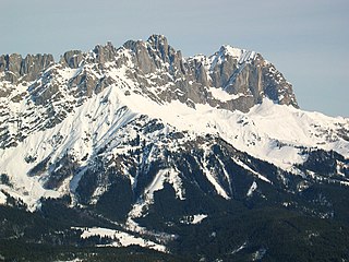
The Kaiser Mountains are a mountain range in the Northern Limestone Alps and Eastern Alps. Its main ridges – are the Zahmer Kaiser and south of it the Wilder Kaiser. The mountains are situated in the Austrian province of Tyrol between the town of Kufstein and the town of St. Johann in Tirol. The Kaiser Mountains offer some of the loveliest scenery in all the Northern Limestone Alps.
The Bavarian Prealps are a mountain range within the Northern Limestone Alps along the Austria–Germany border. They include the Bavarian Prealp region between the river Loisach to the west and the river Inn to the east; the range is about 80 kilometres (50 mi) long and 20–30 kilometres (12–19 mi) wide. The term is not defined politically, but alpine-geographically because, although the range is mostly located in Bavaria, southeast Germany, small areas of the Bavarian Prealps lie in the state of Tyrol, Austria.

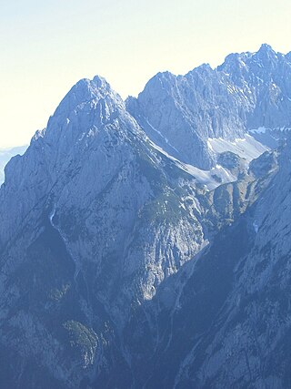
The Ellmauer Halt (2,344 m) is the highest peak in the mountain massif of the Wilder Kaiser in the Kaiser range in the Austrian state of Tyrol. To the east is the summit of the Kapuzenturm, a striking and isolated rock pinnacle. In 1883 the first summit cross was erected on the mountain top.

The Rotwand is a 1,884 m high peak in the Mangfall Mountains in Bavaria, the highest summit in the Spitzingsee region and one of the most popular of Munich's local mountains (Hausberge). The summit may be reached in an easy hike from the lake of Spitzingsee on various routes . The summit can be attained even more easily from the nearby mountain station on the Taubenstein and, as a result, can often become rather overcrowded on summer's days.

The Wörner is a 2,476 m high mountain in the Karwendel on the border between Bavaria and Tyrol. It is part of the Northern Karwendel Chain that initially runs northwards to the Wörner and then swings east. The northwest ridge (Nordwestgrat) of the Wörner is very striking and easy to make out from many other peaks in the region.

The Stripsenjochhaus is an Alpine club hut owned by the Kufstein branch of the Austrian Alpine Club in the Kaisergebirge mountain range in the Austrian state of Tyrol.
The Ellmauer Tor is a 2,000-metre high rock saddle in the middle of the Kaisergebirge in the Austrian state of Tyrol.
The Goinger Halt is a mountain in the Kaisergebirge range in the Northern Limestone Alps in Austria. It has a double summit: a northern top to the rear, the Hintere Goinger Halt, and a higher, southern top in front, the Vordere Goinger Halt. The name "Halt" means something like Alpine meadow and refers therefore to the peak over the meadow areas, that belong to the parish of Going.
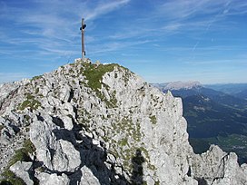
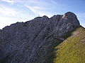
At 2,329 metres above sea level, the Ackerlspitze is the second highest peak in the Kaisergebirge range in the east of the Austrian state of Tyrol. The mountain is located in the eastern part of the range, also referred to as the Ostkaiser or East Kaiser. To the east it is flanked by the Maukspitze (2.231 m), to the north it sends a ridge to the Lärcheck (2,123 m). To the southwest a prominent, rocky arête runs over to the Regalmspitze (2,253 m) and on to the Kleines Törl. To the south the Ackerlspitze drops steeply, with vertical rock faces in places, into the Leukental valley. To the northwest it falls away just as steeply into the Griesner Cirque and to the northeast into the Mauk Cirque (Maukkar). On fine days there is an attractive and extensive panoramic view from the summit of the Ackerlspitze over the neighbouring mountain groups and as far as the Chiemsee lake in Bavaria as well as the Großvenediger.

The Fritz Pflaum Hut is an Alpine club hut belonging to the Bayerland Section of the German Alpine Club, located in the Kaisergebirge mountains in the Austrian federal state of Tyrol.

The Gaudeamus Hut is an Alpine club hut in the Kaisergebirge mountains in Tyrol. It is run by the Main-Spessart section of the German Alpine Club.

The Ackerl Hut is an Alpine club hut in the Wilder Kaiser mountains in Austria. It is run by the Kitzbühel section of the Austrian Alpine Club and lies at a height of 1,455 metres (4,774 ft) below the south faces of the Regalmspitze, Ackerlspitze and Maukspitze.

The Regalmspitze is a 2,253 metres (7,392 ft) high, lesser known mountain in the Kaisergebirge in the Northern Limestone Alps in Austria. The name Regalmwand, refers to the 2,227 metres (7,306 ft) high subpeak to the west of the Regalmspitze.
The Lärchegg is a 2,123-metre-high (6,965 ft) mountain in the Kaisergebirge range of the Northern Limestone Alps in Austria.

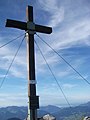
The Karlspitzen is a twin-peaked mountain in the middle of the Kaisergebirge range of the Northern Limestone Alps in Austria. The two peaks are the northern Hintere Karlspitze and the southern Vordere Karlspitze with its summit cross; they are linked by a sharp, exposed, rocky arête. Seen from the south the Vordere Karlspitze is a huge and very prominent block of rock, whereas the Hintere Karlspitze is hidden behind other (lower) neighbouring mountains.

The Sonneck is a 2,260-metre-high (7,410 ft) mountain in the Kaisergebirge range of the Northern Limestone Alps in Austria. On its broad peak stands a solid summit cross, the panorama is comprehensive and there are particularly good views of the Ellmauer Halt, the highest mountain in the range, the Treffauer and Lake Hinterstein.
The Fritzerkogel is a mountain in the Tennengebirge in the northern Limestone Alps, Austria. With its elevation of 2,360 metres (7,740 ft), is one of the higher peaks in the mountain range. Seen from the north it stands out as a relatively isolated, broad summit block, whose mighty rock faces and steep, rugged, rocky flanks (Schrofen) fall away on all sides. Its 1,200-metre-high (3,900 ft) south cliff face is impressive and makes it a striking two-thousander.