Toledo is a city in and the county seat of Lucas County, Ohio, United States. Toledo is in northwest Ohio, at the western end of Lake Erie bordering the state of Michigan. The city was founded in 1833 on the west bank of the Maumee River, and originally incorporated as part of Monroe County, Michigan Territory. It was re-founded in 1837, after conclusion of the Toledo War, when it was incorporated in Ohio.
The Toledo War (1835–36), also known as the Michigan–Ohio War, was an almost bloodless boundary dispute between the U.S. state of Ohio and the adjoining territory of Michigan.

The Maumee River is a river running from northeastern Indiana into northwestern Ohio and Lake Erie in the United States. It is formed at the confluence of the St. Joseph and St. Marys rivers, where Fort Wayne, Indiana, has developed, and meanders northeastwardly for 137 miles (220 km) through an agricultural region of glacial moraines before flowing into the Maumee Bay of Lake Erie. The city of Toledo is located at the mouth of the Maumee. The Maumee was designated an Ohio State Scenic River on July 18, 1974. The Maumee watershed is Ohio’s breadbasket; it is two-thirds farmland, mostly corn and soybeans. It is the largest watershed of any of the rivers feeding the Great Lakes, and supplies five percent of Lake Erie’s water.

The Wabash River is a 503-mile-long (810 km) river in Ohio and Indiana, United States, that flows from the headwaters near the middle of Ohio's western border northwest then southwest across northern Indiana turning south along the Illinois border where the southern portion forms the Indiana-Illinois border before flowing into the Ohio River. It is the largest northern tributary of the Ohio River. From the dam near Huntington, Indiana, to its terminus at the Ohio River, the Wabash flows freely for 411 miles (661 km). Its watershed drains most of Indiana. The Tippecanoe River, White River, Embarras River and Little Wabash River are major tributaries. The river's name comes from an Illini Indian word meaning "water over white stones".

The Wabash and Erie Canal was a shipping canal that linked the Great Lakes to the Ohio River via an artificial waterway. The canal provided traders with access from the Great Lakes all the way to the Gulf of Mexico. Over 460 miles long, it was the longest canal ever built in North America.

The Watersheds of Indiana consist of six distinct Indiana watershed regions that drain into five major bodies of water.

The Great Black Swamp, was a glacially fed wetland in northwest Ohio and extreme northeast Indiana, United States, that existed from the end of the Wisconsin glaciation until the late 19th century. Comprising extensive swamps and marshes, with some higher, drier ground interspersed, it occupied what was formerly the southwestern part of proglacial Lake Maumee, a holocene precursor to Lake Erie. The area was about 25 miles (40 km) wide and 100 miles (160 km) long, covering an estimated 1,500 square miles (4,000 km2). Gradually drained and settled in the second half of the 19th century, it is now highly productive farm land.

The St. Marys River is a 99-mile-long (159 km) tributary of the Maumee River in northwestern Ohio and northeastern Indiana in the United States. Prior to development, it was part of the Great Black Swamp. Today, it drains a primarily rural farming region in the watershed of Lake Erie.
The Miami and Erie Canal was a 274-mile (441 km) canal that ran from Cincinnati to Toledo, Ohio, creating a water route between the Ohio River and Lake Erie. Construction on the canal began in 1825 and was completed in 1845 at a cost to the state government of $8,062,680.07. At its peak, it included 19 aqueducts, three guard locks, 103 canal locks, multiple feeder canals, and a few man-made water reservoirs. The canal climbed 395 feet (120 m) above Lake Erie and 513 feet (156 m) above the Ohio River to reach a topographical peak called the Loramie Summit, which extended 19 miles (31 km) between New Bremen, Ohio to lock 1-S in Lockington, north of Piqua, Ohio. Boats up to 80 feet long were towed along the canal by mules, horses, or oxen walking on a prepared towpath along the bank, at a rate of four to five miles per hour.
Miami is the autonym for the Miami Indians once of Ohio, Indiana, and Michigan.

Turtle Island is a 1.5-acre (0.61 ha) island in the western portion of Lake Erie in the United States. The island has an unusual political status, as its jurisdiction is divided between the U.S. states of Michigan and Ohio, even though the island has no residents or current use. Turtle Island is located about five miles (8.0 km) northeast of the mouth of the Maumee River in Maumee Bay. Today, the island houses several abandoned structures and the ruins of Turtle Island Light, a lighthouse dating back to 1866. According to the Census Bureau, most of the island lies in Jerusalem Township in Lucas County, Ohio with the smaller Michigan portion being part of Erie Township.

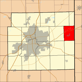
Dover Township is one of the twelve townships of Fulton County, Ohio, United States. The 2010 census found 1,578 people in the township, and estimated a population of 1,570 for 2014.

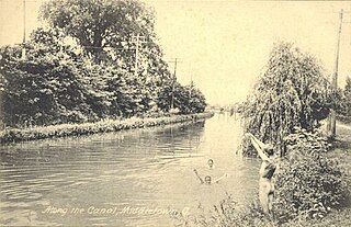
Providence is a ghost town on the north side of the Maumee River in southern Providence Township, Lucas County, Ohio, United States, about 24 miles (39 km) southwest of Toledo. After suffering a destructive fire and a cholera epidemic in mid-19th century, the village was abandoned. In this period, canal traffic had also fallen off.

Lake Erie Basin consists of Lake Erie and surrounding watersheds, which are typically named after the river, creek, or stream that provides drainage into the lake. The watersheds are located in the states of Indiana, Michigan, New York, Ohio, and Pennsylvania in the United States, and in the Province of Ontario in Canada. The basin is part of the Great Lakes Basin and Saint Lawrence River Watershed, which feeds into the Atlantic Ocean. 80% of the lake's water flows in from the Detroit River, with only 9% coming from all of the remaining watersheds combined. A littoral zone serves as the interface between land and lake, being that portion of the basin where the lake is less than 15 feet (4.6 m) in depth.
Mary Jane Thurston State Park is a 591-acre (239 ha) Ohio state park in Wood and Henry Counties, Ohio in the United States. It is named for Mary Jane Thurston, a schoolteacher from Grand Rapids, Ohio who bequeathed 14 acres (57,000 m2) of land for the establishment of a park. The park is along the Maumee River near the remains of the historic Miami and Erie Canal. Mary Jane Thurston State Park is open for year-round recreation including, hunting, fishing and boating, picnicking, camping and hiking.
USCGC Tupelo WAGL/WLB-303, was a Cactus (A) Class 180 foot buoy tender built by Zenith Dredge Company of Duluth, Minnesota. Her keel was laid 15 August 1942, launched 28 November 1942 and commissioned on 30 August 1943. She was built as a WAGL and redesignated a WLB in 1965.

Point Place is a neighborhood in North Toledo, Ohio. Point Place was originally part of Washington Township, Lucas County in the 1800s, and was annexed into the city of Toledo, Ohio in 1937. Point Place is surrounded by the Ottawa River, Lake Erie, the Maumee Bay and the Maumee River. Point Place is near two major interstates, I-75, and I-280, which connects to I-80 (I-80/90). Summit Street runs through the middle of Point Place, and serves as the major center of commerce.