The Toledo War (1835–1836), also known as the Michigan–Ohio War or Ohio–Michigan War, was a boundary dispute between the U.S. state of Ohio and the adjoining territory of Michigan over what is now known as the Toledo Strip. Control of the mouth of the Maumee River and the inland shipping opportunities it represented, and the good farmland to the west, were seen by both parties as valuable economic assets.

Paulding County is a county located in the U.S. state of Ohio. As of the 2020 census, the population was about 18,806. Its county seat is Paulding. The county was created in 1820 and later organized in 1839. It is named for John Paulding, one of the captors of Major John André in the American Revolutionary War.

Miami County is a county located in the U.S. state of Indiana. As of 2020, the population was 35,962. The county seat is the City of Peru. Miami County is part of the Kokomo-Peru CSA.

Cass County is a county located in the U.S. state of Indiana. As of the 2020 United States Census, its population was 37,870. The county seat is Logansport. Cass County comprises the Logansport, IN Micropolitan Statistical Area.

The Miami are a Native American nation originally speaking the Miami–Illinois language, one of the Algonquian languages. Among the peoples known as the Great Lakes tribes, they occupied territory that is now identified as north-central Indiana, southwest Michigan, and western Ohio. The Miami were historically made up of several prominent subgroups, including the Piankeshaw, Wea, Pepikokia, Kilatika, Mengakonkia, and Atchakangouen. In modern times, Miami is used more specifically to refer to the Atchakangouen. By 1846, most of the Miami had been forcefully displaced to Indian Territory. The Miami Tribe of Oklahoma are the federally recognized tribe of Miami Indians in the United States. The Miami Nation of Indiana, a nonprofit organization of self-identified descendants of Miamis who were exempted from removal, have unsuccessfully sought separate recognition.

The Maumee River is a river running in the United States Midwest from northeastern Indiana into northwestern Ohio and Lake Erie. It is formed at the confluence of the St. Joseph and St. Marys rivers, where Fort Wayne, Indiana has developed, and meanders northeastwardly for 137 miles (220 km) through an agricultural region of glacial moraines before flowing into the Maumee Bay of Lake Erie. The city of Toledo is located at the mouth of the Maumee. The Maumee was designated an Ohio State Scenic River on July 18, 1974. The Maumee watershed is Ohio's breadbasket; it is two-thirds farmland, mostly corn and soybeans. It is the largest watershed of any of the rivers feeding the Great Lakes, and supplies five percent of Lake Erie's water.

The Wabash River is a 503-mile-long (810 km) river that drains most of the state of Indiana, and a significant part of Illinois, in the United States. It flows from the headwaters in Ohio, near the Indiana border, then southwest across northern Indiana turning south near the Illinois border, where the southern portion forms the Indiana-Illinois border before flowing into the Ohio River.

The St. Marys River is a 99-mile-long (159 km) tributary of the Maumee River in northwestern Ohio and northeastern Indiana in the United States. Prior to development, it was part of the Great Black Swamp. Today, it drains a primarily rural farming region in the watershed of Lake Erie.

The Eel River is a 94-mile-long (151 km) tributary of the Wabash River in northern Indiana in the United States. Via the Wabash and Ohio rivers, its waters flow to the Mississippi River and ultimately the Gulf of Mexico. The Eel River rises southeast of Huntertown in Allen County and flows southwest through Allen, Whitley, Kosciusko, Wabash, Miami, and Cass counties to join the Wabash at Logansport. The river was called Kineepikwameekwa Siipiiwi - "river of the snake fish" by the Miami people, who inhabited the area at the time of European contact, the English rendered it as Ke-na-po-co-mo-co. It is the northern of the two rivers named Eel River within Indiana.
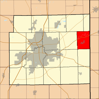
As of March 2020, the Fort Wayne–Huntington–Auburn Combined Statistical Area (CSA), or Fort Wayne Metropolitan Area, or Northeast Indiana is a federally designated metropolitan area consisting of eight counties in northeast Indiana, anchored by the city of Fort Wayne.

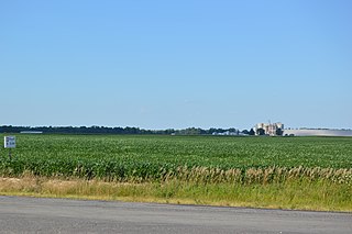
Milan Township is one of twenty townships in Allen County, Indiana, United States. Milan Township is located in east central Allen County, with the Maumee River meandering across the township. As of the 2010 census, its population was 3,749. The township is highly rural, with only 1,137 houses in the 2010 census. Many of the residents of Milan Township are Swiss Amish who mostly speak a Low Alemannic Alsatian dialect. Milan township is generally demarcated by Schwartz Road to the west, Notestine Road to the north, Sampson Road to the east, and Gar Creek Road to the south.

Jackson Township is one of fourteen townships in Cass County, Indiana. As of the 2020 census, its population was 2,773 and contained 1,246 housing units.

Tipton Township is one of fourteen townships in Cass County, Indiana, United States. As of the 2020 census, its population was 2,304 and contained 1,011 housing units.

Harrison Township is one of fourteen townships in Miami County, Indiana, United States. As of the 2020 census, its population was 665 and it contained 272 housing units.
Jackson Township is one of fourteen townships in Miami County, Indiana, United States. As of the 2020 census, the town's population is 1,966 and it contained 843 housing units as of 2010.

Jackson Township is one of twenty townships in Allen County, Indiana, United States. As of the 2010 census, its population was 504.

Jefferson Township is one of twenty townships in Allen County, Indiana, United States. As of the 2010 census, its population was 2,109. Jefferson Township was organized in 1840.
Maumee Township is one of twenty townships in Allen County, Indiana, United States. As of the 2010 census, its population was 2,620.

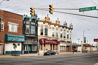
Springfield Township is one of twenty townships in Allen County, Indiana, United States. As of the 2010 census, its population was 4,349. The principal town in Springfield Township is the village of Harlan.


