Ewing, Indiana

Last updated

Ewing is an unincorporated community in Jackson County, Indiana, in the United States. [1]

Jackson County, Indiana County in Indiana, US

Jackson County is a county located in the U.S. state of Indiana. As of 2010, the population was 42,376. The county seat is Brownstown.

United States Federal republic in North America

The United States of America (USA), commonly known as the United States or America, is a country comprising 50 states, a federal district, five major self-governing territories, and various possessions. At 3.8 million square miles, the United States is the world's third or fourth largest country by total area and is slightly smaller than the entire continent of Europe. With a population of over 327 million people, the U.S. is the third most populous country. The capital is Washington, D.C., and the most populous city is New York City. Most of the country is located contiguously in North America between Canada and Mexico.

History

Ewing was laid out in 1857 by William H. Ewing when it was certain that the railroad would be extended to that point. [2] A post office was established at Ewing in 1857, and remained in operation until it was discontinued in 1967. [3]

Related Research Articles

Cass Township, White County, Indiana Township in Indiana, United States

Cass Township is one of twelve townships in White County, Indiana, United States. As of the 2010 census, its population was 585 and it contained 228 housing units.

Koleen, Indiana Unincorporated community in Indiana, United States

Koleen is an unincorporated community in Jackson Township, Greene County, Indiana.

Byrneville, Indiana Unincorporated community in Indiana, United States

Byrneville is an unincorporated community in Jackson Township, Harrison County, Indiana.

Mott Station, Indiana Unincorporated community in Indiana, United States

Mott Station is an unincorporated community in Jackson Township, Harrison County, Indiana.

Ramsey, Indiana Unincorporated community in Indiana, United States

Ramsey is an unincorporated community in Jackson Township, Harrison County, in the U.S. state of Indiana.

Acme, Indiana Unincorporated community in Indiana, United States

Acme is an unincorporated community in Hamilton Township, Jackson County, Indiana.

Clear Spring, Indiana Unincorporated community in Indiana, United States

Clear Spring is an unincorporated community in Owen Township, Jackson County, Indiana.

Freetown, Indiana Census-designated place in Indiana, United States

Freetown is an unincorporated community and census-designated place in Pershing Township, Jackson County, Indiana, United States. As of the 2010 census the population was 385.

Houston, Indiana Unincorporated community in Indiana, United States

Houston is an unincorporated community in Salt Creek Township, Jackson County, Indiana.

Kurtz, Indiana Unincorporated community in Indiana, United States

Kurtz is an unincorporated community in Owen Township, Jackson County, Indiana.

New Farmington, Indiana Unincorporated community in Indiana, United States

New Farmington is an unincorporated community in Jackson Township, Jackson County, Indiana.

Sparksville, Indiana Unincorporated community in Indiana, United States

Sparksville is an unincorporated community in Carr Township, Jackson County, Indiana.

Spraytown, Indiana Unincorporated community in Indiana, United States

Spraytown is an unincorporated community in Pershing Township, Jackson County, Indiana, United States.

Surprise, Indiana Unincorporated community in Indiana, United States

Surprise is an unincorporated community in Hamilton Township, Jackson County, Indiana.

Weddleville, Indiana Unincorporated community in Indiana, United States

Weddleville is an unincorporated community in Carr Township, Jackson County, Indiana.

Georgia, Indiana Unincorporated community in Indiana, United States

Georgia is an unincorporated community in Spice Valley Township, Lawrence County, Indiana.

Norman, Indiana Unincorporated community in Indiana, United States

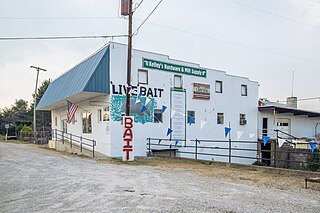
Norman is an unincorporated community in northwestern Owen Township, Jackson County, Indiana, United States. It lies along State Road 58 northwest of the town of Brownstown, the county seat of Jackson County. Its elevation is 869 feet (265 m), and it is located at 38°57′9″N86°16′30″W. Because the community had two different names, the Board on Geographic Names officially decided in favor of "Norman" in 1943. Although Norman is unincorporated, it has a post office, with the ZIP code of 47264.

Mill Creek is a stream in Jackson County, Indiana, in the United States. It is a tributary to the White River.

Newry is an unincorporated community in Jackson County, Indiana, in the United States.

Conologue is an unincorporated community in Jackson County, Indiana, in the United States.

References

  1. U.S. Geological Survey Geographic Names Information System: Ewing, Indiana
  2. History of Jackson County, Indiana: From the Earliest Time to the Present, with Biographical Sketches, Notes, Etc., Together with an Extended History of the Northwest, the Indiana Territory and the State of Indiana. Unigraphic. 1886. p. 366.
  3. "Jackson County". Jim Forte Postal History. Archived from the original on 19 October 2014. Retrieved 19 October 2014.

Coordinates: 38°53′05″N86°03′19″W / 38.88472°N 86.05528°W / 38.88472; -86.05528

Geographic coordinate system Coordinate system

A geographic coordinate system is a coordinate system that enables every location on Earth to be specified by a set of numbers, letters or symbols. The coordinates are often chosen such that one of the numbers represents a vertical position and two or three of the numbers represent a horizontal position; alternatively, a geographic position may be expressed in a combined three-dimensional Cartesian vector. A common choice of coordinates is latitude, longitude and elevation. To specify a location on a plane requires a map projection.