Puka-Puka is a small inhabited coral atoll in the north-eastern Tuamotu Archipelago, sometimes included as a member of the Disappointment Islands. This atoll is quite isolated, the nearest land being Fakahina, 182 km to the southwest.
Napuka, or Pukaroa, is a small coral atoll in the Disappointment Islands, in the northeastern part of the Tuamotu Archipelago in French Polynesia. It is located only 15 km to the southeast of Tepoto Nord, its nearest neighbor, forming a small group. These two atolls are quite isolated, the nearest land being Fangatau Atoll 170 km to the south.
Hao, or Haorangi, is a large coral atoll in the central part of the Tuamotu Archipelago. It has c. 1000 people living on 35 km2 (14 sq mi). It was used to house the military support base for the nuclear tests on Mururoa. Because of its shape, French explorer Louis Antoine de Bougainville named it "Île de la Harpe".
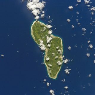
Rūrutu is the northernmost island in the Austral archipelago of French Polynesia, and the name of a commune consisting solely of that island. It is situated 572 km (355 mi) south of Tahiti. Its land area is 32.7 km2 (12.6 sq mi). It is 10.8 km long and 5.3 km wide. Its highest point (Manureva) is 389 m (1,276 ft). At the 2022 census it had a population of 2,163.

Arue is a commune in the suburbs of Papeete in French Polynesia, an overseas territory of France in the Pacific Ocean. Arue is located on the island of Tahiti, in the administrative subdivision of the Windward Islands, themselves part of the Society Islands. At the 2022 census it had a population of 10,322.

In French Polynesia, there are two levels of administrative divisions: five administrative subdivisions and 48 communes. Many of the communes are further subdivided into communes associées. The breakdown into administrative subdivisions was as a result of the law #71-1028, dated December 24, 1971. The compositions of the administrative subdivisions and the communes were defined in the decrees #72-408 and #72-407 of May 17, 1972, respectively. These subdivisions were confirmed in the decree #2005-1611 of December 20, 2005. Below are several lists of the divisions, according to different sorting schemes.
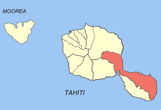
Taiʻarapu-Est is a commune of French Polynesia, an overseas territory of France in the Pacific Ocean. The commune of Taiʻarapu-Est is located on the island of Tahiti, in the administrative subdivision of the Windward Islands, themselves part of the Society Islands At the 2022 census it had a population of 13,602. The whole island of Mehetia is part of the commune.
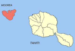
Moorea-Maiao is a commune of French Polynesia, an overseas territory of France in the Pacific Ocean. It consists of the island of Mo'orea and the much smaller atoll of Maiao, located 78 km (48 mi) southwest of Mo'orea, with both being part of the Windward Islands administrative subdivision. As of the 2022 census, Moorea-Maiao had a population of 18,201, of whom 17,858 lived on Mo'orea and 343 lived on Maiao.

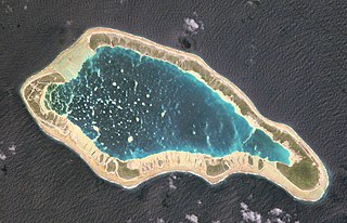
Anaa, Nganaa-nui is an atoll in the Tuamotu archipelago, in French Polynesia. It is located in the north-west of the archipelago, 350 km to the east of Tahiti. It is oval in shape, 29.5 km in length and 6.5 km wide, with a total land area of 38 km2 and a population of 504. The atoll is made up by eleven small barren islands with deeper and more fertile soil than other atolls in the Tuamotus. The lagoon is shallow, without entrance, and formed by three main basins. Although it does not have any navigable access, the water of the lagoon renews by several small channels that can be crossed walking.

Nukutavake or Nukutuvake is an island in the Tuamotu group in French Polynesia. It lies 1125 km from Tahiti. The closest land is small Pinaki Atoll, located 15 km to the southeast. Vairaatea Atoll lies 38 km to the west of Nukutavake.
Tureia is an atoll in the Tuamotu Archipelago in French Polynesia.

Makemo, Rangi-kemo or Te Paritua, is an inhabited atoll in the Tuamotu archipelago in French Polynesia.

Arutua, or Ngaru-atua is an atoll in the Tuamotu group in French Polynesia. It is located 40 km SW of Rangiroa. The closest land is Apataki Atoll, only 16 km to the East.
Fangatau, or Nakai-erua, is a small atoll in the Tuamotu group in French Polynesia. The nearest land is Fakahina Atoll, located 72 km to the ESE. This small atoll has an elongated shape. Its length is 8 kilometres, maximum width 3.5 kilometres. It has a total area of 22.2 square kilometres, land area 5.9 km2. Its reef encloses its lagoon completely. Anchorage is difficult. Fangatau Atoll has 150 inhabitants. Teana is the main village.

Reao or Natūpe is an atoll in the eastern expanses of the Tuamotu group in French Polynesia. The closest land is Pukarua Atoll, located 48 km to the WNW.
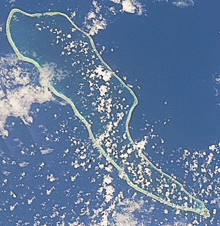
Takaroa, Taka-roa or Takapua, is an atoll in the Tuamotu group in French Polynesia. It has a length of 27.4 kilometres and a width of 7 km (4 mi); its land area is 20 square kilometres.

Tatakoto is an atoll in the Tuamotu group in French Polynesia.

Nuku-Hiva is a commune of French Polynesia, an overseas territory of France in the Pacific Ocean. The commune is in the administrative subdivision of the Marquesas Islands. Its population was 3,025 at the 2022 census.

Gambier is a commune of French Polynesia in the administrative subdivision of the Tuamotu-Gambier Islands. The commune includes the Gambier Islands as well as several atolls in the Tuamotu Archipelago. All the Tuamotu atolls belonging to the commune are uninhabited except for Marutea Sud, and are sometimes mistakenly included among the Gambier Islands themselves. The commune population was 1,570 at the 2022 census. Its total land area is 45.97 km2.

Bora-Bora is a commune of French Polynesia, an overseas territory of France in the Pacific Ocean. The commune is in the administrative subdivision of the Leeward Islands. Its population was 10,758 at the 2022 census.