Mauritius (1618 ship)

Last updated
Mauritius
Mauritius - Detail uit Het uitzeilen van een aantal Oost-Indievaarders van Hendrick Cornelisz Vroom (1600).jpg
VOC ship Mauritius ca 1618 [?] Painting from the Rijksmuseum, Amsterdam
History
Flag of the Dutch East India Company.svg Netherlands
Name:Mauritius
Namesake: The island of Mauritius
Owner: Dutch East India Company
Route: Holland to Bantam, Indonesia
In service: 1618-1622 (Documented)
General characteristics VOC Ship Mauritius
Type: Wooden-hulled sailing ship
Service record
Commanders: Willem Janszoon and Lenaert Jacobszoon

The Mauritius was an early 17th Century Dutch wooden-hulled sailing ship, documented as being in service to the Dutch East India Company between 1618 and 1622. [1]

Dutch Republic Republican predecessor state of the Netherlands from 1581 to 1795

The Dutch Republic, or the United Provinces, was a confederal republic that existed from the formal creation of a confederacy in 1581 by several Dutch provinces—seceded from Spanish rule—until the Batavian Revolution of 1795. It was a predecessor state of the Netherlands and the first Dutch nation state.

Hull (watercraft) watertight body of a ship or boat

A hull is the watertight body of a ship or boat. The hull may open at the top, or it may be fully or partially covered with a deck. Atop the deck may be a deckhouse and other superstructures, such as a funnel, derrick, or mast. The line where the hull meets the water surface is called the waterline.

Sailing ship Large wind-powered water vessel

A sailing ship is a large watercraft that uses sails to harness the power of wind. A "ship-rigged" sailing ship carries three or more masts with square sails on each. Other large sailing vessels, that are not ship-rigged, may be more precisely referred to by their sail rig, such as schooner, barque, brig, barkentine, brigantine or sloop.

Contents

History

1618 Discoveries

On the 1618 voyage, the ship was commanded by Supercargo Willem Janszoon and captained by Lenaert Jacobszoon, when they sighted North West Cape in Western Australia on 31 July 1618. [1] On that occasion they had believed that the mainland peninsular west of the Exmouth Gulf, was an island. [1] They went ashore there and it is written that they discovered human footprints, as follows. [1]

A supercargo is a person employed on board a vessel by the owner of cargo carried on the ship. The duties of a supercargo are defined by admiralty law and include managing the cargo owner's trade, selling the merchandise in ports to which the vessel is sailing, and buying and receiving goods to be carried on the return voyage.

Willem Janszoon, sometimes abbreviated to Willem Jansz., was a Dutch navigator and colonial governor. Janszoon served in the Netherlands East Indies in the periods 1603–1611 and 1612–1616, including as governor of Fort Henricus on the island of Solor. He is the first European known to have seen the coast of Australia during his voyage of 1605–1606.

Lenaert Jacobszoon was a captain of the Dutch East India Company who, on 31 July 1618 in the vessel Mauritius, sighted North West Cape in the north-west of Western Australia mistakenly believing it to be a large island. He also named the Willems River and the Jocob Remmessens River in the same voyage.

Letter Of supercargo WILLEM JANSZ(OON) to the Managers of the Amsterdam Chamber, October 6, 1618. A. Worshipful Wise Provident Discreet Gentlemen,

(Sailed 1000 miles to eastward in 38 degrees with notable success.)

The present serves only to inform you that on the 8th of June last with the ship Mauritius we passed Cape de bon esperence, with strong westerly winds, so that we deemed it inadvisable to call at any land, after which we ran a thousand miles to eastward in 38 degrees Southern Latitude, though we should have wished to go still further east.

On the 31st of July we discovered an island and landed on the same, where we found the marks of human footsteps--on the west-side it extends N.N.E. and S.S.W.; it measures 15 miles in length, and its northern extremity is in 22° S. Lat. It bears Eendracht S.S.E. and N.N.W. from the south-point of Sunda at 240 miles' distance; from there (Eendrachtsland [2] ) through God's grace we safely arrived before Bantam on the 22nd of August...

Done on board the ship 't Wapen van Amsterdam, October 6, 1618. [1]

1627 Chart of Eendrachtsland

Caert van't Landt van d'Eendracht Caert van't Landt van d'Eendracht (NLA balanced).jpg
Caert van't Landt van d'Eendracht

The Mauritius is mentioned on the Caert van't Landt van d'Eendracht ("Chart of the Land of Eendracht"), which is a 1627 chart by Hessel Gerritsz and is one of the earliest charts that shows Australia.

Caert vant Landt van dEendracht 1627 map by Hessel Gerritsz

Caert van't Landt van d'Eendracht is a 1627 map by Hessel Gerritsz. One of the earliest maps of Australia, it shows what little was then known of the west coast, based on a number of voyages beginning with the 1616 voyage of Dirk Hartog, when he named Eendrachtsland after his ship.

Hessel Gerritsz Dutch engraver and cartographer

Hessel Gerritsz was a Dutch engraver, cartographer and publisher. He was one of the notable figures in the Golden Age of Dutch/Netherlandish cartography. Despite strong competition, he is considered by some “unquestionably the chief Dutch cartographer of the 17th century”.

Australia Country in Oceania

Australia, officially the Commonwealth of Australia, is a sovereign country comprising the mainland of the Australian continent, the island of Tasmania and numerous smaller islands. It is the largest country in Oceania and the world's sixth-largest country by total area. The neighbouring countries are Papua New Guinea, Indonesia and East Timor to the north; the Solomon Islands and Vanuatu to the north-east; and New Zealand to the south-east. The population of 25 million is highly urbanised and heavily concentrated on the eastern seaboard. Australia's capital is Canberra, and its largest city is Sydney. The country's other major metropolitan areas are Melbourne, Brisbane, Perth and Adelaide.

Willems Rivier (1618) on the 1627 chart

On the 1618 voyage, the crew visited and partly mapped a river which was named Willems River. [1] Willems River was most likely named after the Commander of the ship Mauritius, Supercargo, Willem Janszoon.

Willem River

The Willem River or Willem's River was named during the voyage of the Dutch East India Company ship Mauritius in 1618, under the command of Supercargo Willem Janszoon and captained by Lenaert Jacobszoon, and is one of the few features named on a nautical chart made in 1627.

Caert van't Landt van d'Eendracht (detail naming the Mauritius as ship used for the discovery of the Willems River) by Hessel Gerritsz, stating, Willems revier, besocht by 't volck van 't Schip Mauritius in Iulius Adeg 1618 ("Willem's River, visited by the crew of the ship Mauritius in July 1618"). [This cropped image has been reoriented 90 degrees right from the original chart with north to top] Caert van't Landt van d'Eendracht (detail showing Willems River).jpg
Caert van't Landt van d'Eendracht (detail naming the Mauritius as ship used for the discovery of the Willems River) by Hessel Gerritsz, stating, Willems revier, besocht by 't volck van 't Schip Mauritius in Iulius A° 1618 ("Willem's River, visited by the crew of the ship Mauritius in July 1618"). [This cropped image has been reoriented 90 degrees right from the original chart with north to top]

The chart shows Willems revier, besocht by 't volck van 't Schip Mauritius in Iulius A° 1618 ("Willem's River, visited by the crew of the ship Mauritius in July 1618").

Commander Willem Janszoon

The Commander of the ship Mauritius, Supercargo, Willem Janszoon, was captain of the Duyfken in 1605-1606, when part of the Gulf of Carpentaria was mapped, during that earliest documented visit to Australia by a vessel from the Netherlands. [1]

Willems Rivier - Ashburton River

The 1618 named Willems River is believed to be the Ashburton River. [3] The detail of the river’s position on the chart backs up the claim that Willems River is the Ashburton River, which, being at 21 degrees 40 minutes south and 114 degrees 56 east, is almost exactly the latitude shown on the chart and discussed in other writing. [1]

Eendrachtsland (1616) - Australia

The chart was based on a number of voyages, beginning with the 1616 voyage of Dirk Hartog. On that voyage Hartog named Eendrachtsland after his ship, the Eendracht meaning "Concord" or "Unity". The name Eendrachtsland appeared on subsequent charts. [1]

Mauritius reaches Bantam

The ship Mauritius reached its destination Bantam, Indonesia on 22 August 1618. [1]

Mauritius is mentioned in September 1622, as follows. [4]

But in the meantime, in the years 1616, 1618, 1619 and 1622, the west coast of this great unknown south land from 35° to 22° S. latitude was discovered by outward bound ships, and among them by the ship Endraght [Eendracht]; for the nearer discovery of which the governor-general, Jan Pietersz Coen (of worthy memory) in September, 1622, despatched the yachts De Haring and Harewind; but this voyage was rendered abortive by meeting the ship Mauritius, and searching after the ship Rotterdam. [4]

Related Research Articles

Abel Tasman Dutch seafarer, explorer and merchant

Abel Janszoon Tasman was a Dutch seafarer, explorer, and merchant, best known for his voyages of 1642 and 1644 in the service of the Dutch East India Company (VOC). He was the first known European explorer to reach the islands of Van Diemen's Land and New Zealand, and to sight the Fiji islands.

European maritime exploration of Australia aspect of history

The maritime European exploration of Australia consisted of several waves of white European seafarers that sailed the edges of the Australian continent. Dutch navigators were the first Europeans known to have explored and mapped the Australian coastline. The first documented encounter was that of Dutch navigator Willem Janszoon, in 1606. Dutch seafarers also visited the west and north coasts of the continent, as did French explorers.

Jacob Le Maire Dutch explorer

Jacob Le Maire was a Dutch mariner who circumnavigated the earth in 1615 and 1616. The strait between Tierra del Fuego and Isla de los Estados was named the Le Maire Strait in his honor, though not without controversy. It was Le Maire himself who proposed to the council aboard Eendracht that the new passage should be called by his name and the council unanimously agreed with Le Maire. The author or authors of The Relation took Eendracht captain Schouten’s side by proclaiming:

Dirk Hartog Dutch explorer

Dirk Hartog was a 17th-century Dutch sailor and explorer. Dirk Hartog's expedition was the second European group to land in Australia and the first to leave behind an artefact to record his visit, the Hartog plate. His name is sometimes alternatively spelled Dirck Hartog or Dierick Hartochszch. Ernest Giles referred to him as Theodoric Hartog.

Dirk Hartog Island island

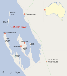
Dirk Hartog Island is an island off the Gascoyne coast of Western Australia, within the Shark Bay World Heritage Area. It is about 80 kilometres long and between 3 and 15 kilometres wide and is Western Australia's largest and most western island. It covers an area of 620 square kilometres and is approximately 850 kilometres north of Perth. It was named after Dirk Hartog, a Dutch sea captain, who first encountered the Western Australian coastline close to the 26th parallel south latitude, which runs through the island. After leaving the island, Hartog continued his voyage north-east along the mainland coast. Hartog gave the Australian mainland one of its earliest known names, as Eendrachtsland, which he named after his ship Eendracht, meaning "Unity".

The human history of Western Australia commenced between 40,000 and 60,000 years ago with the arrival of Indigenous Australians on the northwest coast. The first inhabitants expanded the range of their settlement to the east and south of the continent. The first recorded European contact was in 1616, when Dutch explorer Dirk Hartog landed on the west coast, having been blown off course while en route to Batavia, nowadays called Jakarta.

<i>Duyfken</i> ship built in 1595

Duyfken, also spelled Duifken or Duijfken, was a small ship built in the Dutch Republic. She was a fast, lightly armed ship probably intended for shallow water, small valuable cargoes, bringing messages, sending provisions, or privateering. The tonnage of Duyfken has been given as 25-30 lasten.

Willem Schouten Dutch explorer

Willem Cornelisz Schouten was a Dutch navigator for the Dutch East India Company. He was the first to sail the Cape Horn route to the Pacific Ocean.

The Eendracht was an early 17th Century Dutch wooden-hulled 700 tonne East Indiaman, launched in 1615 in the service of the Dutch East India Company(VOC). It was captained by Dirk Hartog when he made the second recorded landfall by a European on Australian soil, in 1616.

Ashburton River (Western Australia) river in Western Australia

The Ashburton River is located within the Pilbara region of Western Australia.

Eendrachtsland ancient name for Australia

Eendrachtsland or Eendraghtsland was derived from 't Landt van d'Eendracht or Land van de Eendracht and was one of the earliest names given for Australia, being in use for 28 years, from 1616 until 1644.

Hartog Plate archaeological artifact

Hartog Plate or Dirk Hartog's Plate is either of two plates, although primarily the first, which were left on Dirk Hartog Island during a period of European exploration of the western coast of Australia prior to European settlement there. The first plate, left by Dutch explorer Dirk Hartog, is the oldest-known artifact of European exploration in Australia still in existence. The original dish was returned to the Netherlands where it is on display in the Rijksmuseum. A replacement and additional dish were subsequently discovered on three additional visits over the next 200 years

Janszoon voyage of 1605–06

Willem Janszoon made the first recorded European landing on the Australian continent in 1606, sailing from Bantam, Java, in the Duyfken. As an employee of the Dutch East India Company, Janszoon had been instructed to explore the coast of New Guinea in search of economic opportunities. He had originally arrived in Dutch East Indies from the Netherlands in 1598 and became an officer of the VOC on its establishment in 1602.

Leeuwin (galleon) galleon from Netherlands

Leeuwin was a Dutch galleon that discovered and mapped some of the southwest corner of Australia in March 1622. In this way it became only the seventh European ship to sight the continent.

Australian places with Dutch names

Of an estimated 200 place names the Dutch bestowed on Australian localities in the 17th century as a result of the Dutch voyages of exploration along the western, northern and southern Australian coasts, only about 35 can still be found on current maps. Five out of six names were either renamed or forgotten or their locations were lost. Other places were named after the early Dutch explorers by later British explorers or colonists, for instance the Australian state of Tasmania is named after Abel Tasman. Australia itself was called New Holland by the English and Nieuw Holland by the Dutch.

References

  1. 1 2 3 4 5 6 7 8 9 10 Heeres, Jan Ernst (1899). The Part Borne by the Dutch in the Discovery of Australia 1606-1765 (txt). London: Royal Dutch Geographical Society, Luzac & Co. Retrieved 28 Oct 2012.
  2. This marginal note was made by an official of the East India Company, when the letter had reached its destination.
  3. Tent, Jan (March 2006). "The importance of bygone placenames" (pdf). Placenames Australia - Newsletter of the Australian National Placenames Survey: 10–11. Retrieved 10 Feb 2014.
  4. 1 2 Major, Richard Henry (ed) (1859). Early Voyages to Terra Australis, now called Australia. London: The Hakluyt Society. Retrieved 10 Feb 2014.