Mazinde is a historic town and ward located in Korogwe District of the Tanga Region of Tanzania.[1] Mazinde was a prominent location within the historical framework of the Shambaa kingdom of the Usambara mountains. Established as a commercial center under the leadership of Semboja in the early 19th century, Mazinde played a crucial role in the region's trade dynamics, particularly during a period marked by the shifting political landscape of the time.[2]
Mazinde emerged as a strategic hub for trade and military activities, primarily due to its advantageous geographic positioning. Located in the lowlands of the Shambaa territory, it served as a critical point for merchants and traders, facilitating the exchange of goods between the interior and coastal regions. By the time of Kimweri ye Nyumbai's death in 1862, the power center had shifted away from Vugha. Semboja, one of Kimweri's sons, recognized the growing importance of trade and established a commercial center at Mazinde, strategically positioned for the trade of slaves, guns, and ivory. While he posed a latent threat during his father's lifetime, he did not attack Vugha. However, any political settlements following the old king's death had to consider Mazinde's significance. [3]
Semboja, born to a relatively minor house of the capital, emerged as a key innovator among the Kilindi of his generation. He initially ruled at Gare, then moved to Ngua in the mountains overlooking the Zigula plains, and finally established his headquarters in the Zigula town of Mazinde. Notably, Semboja became the first major Shambaa chief to have his capital in the lowlands (nyika) rather than in the highlands (Shambaai). By 1852, when visited by Krapf, Semboja had firmly established his presence at Mazinde.[4][3]
Location
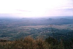
Mazinde lies in the Maasai plains to the west of the West Usambara Mountains. The community is on the main road between Moshi and Dar es Salaam.[5] The cliffs rise almost vertically behind the village to the Irente viewpoint, 800 metres (2,600ft) above.[6]
The rulers of Mazinde, an influential center within the Shambaa kingdom, played pivotal roles in shaping the political, economic, and cultural landscape of the region. Below are the key figures associated with the leadership of Mazinde. [7]
Semboja
Semboja was a notable monarch who recognized the strategic significance of Mazinde and relocated his headquarters there. Under his leadership, Mazinde transformed into a crucial commercial hub, emphasizing trade in slaves, ivory, and firearms. Semboja's focus on trade allowed him to consolidate power and expand his influence throughout the region. He established alliances with various ethnic groups and local leaders, integrating diverse cultural elements into Mazinde.[7]
His court was characterized by a blend of cultural influences, as evidenced by his adoption of various materials and practices from neighboring societies. Semboja's leadership style exemplified a spirit of eclecticism, as he sought to enhance his cultural and political universe.[7]
Kinyashi Muanga Ike
Kinyashi Muanga Ike was the predecessor of Semboja and played a significant role in expanding the Shambaa kingdom into eastern territories. His reign was marked by military conquests that brought tribute to the capital. Kinyashi's victories enabled the Shambaa kingdom to acquire new subjects, though the loyalty of these subjects was often questionable due to their alien origins. His expansionist policies ultimately contributed to the internal challenges faced by the kingdom.[7]
Kimweri ye Nyumbai, the son of Kinyashi, ascended to the throne around 1815 and is often regarded as a key figure in the history of the Shambaa kingdom. His reign is remembered as a "golden age," characterized by effective governance and the consolidation of royal authority. Kimweri implemented strategies to maintain control over the diverse territories of the kingdom and was known for his diplomatic relationships with neighboring groups.[7]
Kimweri's administration emphasized the importance of descent groups, particularly the Kilindi lineage, which played a central role in the political organization of the kingdom. His leadership style was marked by a commitment to fostering loyalty among his subjects, including the establishment of checks on local chiefs through maternal uncles.[7]
The rulers of Mazinde, particularly Semboja, Kinyashi, and Kimweri ye Nyumbai, significantly influenced the political and economic dynamics of the Shambaa kingdom. Their strategies in governance, trade, and cultural integration shaped the historical trajectory of Mazinde and contributed to the broader narrative of the Shambaa kingdom's development. [7]
Johann Jakob Erhardt recorded the repulse of a Maasai raid in 1853 at Mazinde by an allied army of Shambaa under Semboja, son of Kimweri ye Nyumbai, and of Wazigua, Parakuyo and "Arabs" (most likely Swahili).[8] One of Kimweri's junior sons, Semboja, was made chief of Mazinde, which lay on the northern caravan route between the coast and the interior.[9] He later allied himself with the Maasai.[10] Semboja followed coastal architecture in the design of the buildings at Mazinda, dressed as an Arab and ate Arab-style food.[11] However, the language at his trading post was Zigula rather than Swahili.[12]
Decline
After Kimweri died, the Shambaa Kingdom split up. Semboja retained authority at Mazinde, while his son Kimweri Maguvu reigned as a puppet in Vugha. In 1885 Kimweri Maguvu signed a treaty with a German agent, but Semboja did not at first support the arrangement. After an unsuccessful attempt to persuade his rivals to unite against the Germans, in February 1890 Semboja received a German force at Mazinde and agreed to raise their flag in return for recognition of his authority.[13]
Economy role
Historically the marketplace at Mazinde became known for its vibrant trade interactions, where local agricultural products were exchanged alongside goods from neighboring regions. The Shambaa and Zigula peoples engaged in reciprocal trading practices, with the former offering bananas and tobacco, while the latter provided metal implements and game meat. Coastal traders occasionally frequented Mazinde, exchanging cowrie shell beads for local specialties, underscoring the area's economic diversity.[7]
The Mazinde estate, owned by Major William Lead in 1930, was a major sisal plantation. In face of strong global competition, he organized East African sisal producers in Tanganyika into Tanganyikan Sisal Grower's Association (TSGA) that year, and reduced wages by 50%.[14] Starting on 25 November 1958 the estate was the scene of a 68-day strike against the TSGA. The government was forced to intervene, and appointed a commission that recommended appointing representative for the plantation workers and establishing a new agreement between the union and the employers.[15] While other sisal estates were nationalized by the post-colonial government, the Mazinde estate remained privately owned by a British national until being sold to M/s Mohammed Enterprises (T) Limited a few years before 2008.[16]
This page is based on this Wikipedia article Text is available under the CC BY-SA 4.0 license; additional terms may apply. Images, videos and audio are available under their respective licenses.