
Hoke County is a county in the U.S. state of North Carolina. As of the 2020 census, its population was 52,082. Its county seat is Raeford.
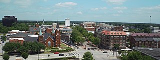
Fayetteville is a city in and the county seat of Cumberland County, North Carolina, United States. It is best known as the home of Fort Liberty, a major U.S. Army installation northwest of the city.

Fort Liberty, formerly Fort Bragg, is a military installation of the United States Army in North Carolina, and is one of the largest military installations in the world by population, with over 52,000 military personnel. The military reservation is located within Cumberland and Hoke counties, and borders the incorporated city and communities of Fayetteville, Spring Lake, and Southern Pines.

Garrison Dam is an earth-fill embankment dam on the Missouri River in central North Dakota, U.S. Constructed by the U.S. Army Corps of Engineers from 1947 to 1953, at over two miles (3.2 km) in length, the dam is the fifth-largest earthen dam in the world. The reservoir impounded by the dam is Lake Sakakawea, which extends to Williston and the confluence with the Yellowstone River, near the Montana border. The dam and resulting reservoir inundated approximately one-sixth (16.6%) to one-fourth (25%) of Fort Berthold Indian Reservation's land, resulting in the loss of homes, farmland, and community infrastructure for the Three Affiliated Tribes.

Big Bend Dam is a major embankment rolled-earth dam on the Missouri River in Central South Dakota, United States, creating Lake Sharpe. The dam was constructed by the U.S. Army Corps of Engineers as part of the Pick-Sloan Plan for Missouri watershed development authorized by the Flood Control Act of 1944. Construction began in 1959 and the embankment was completed in July 1963. Power generation began at the facility in 1964 and the entire complex was completed in 1966 at a total cost of $107 million. The hydroelectric plant generates 493,300 kilowatts of electricity at maximum capacity, with an annual production of 969 million kilowatt hours, and meets peak-hour demand for power within the Missouri River Basin.

The Oahe Dam is a large earthen dam on the Missouri River, just north of Pierre, South Dakota, United States. Begun in 1948 and opened in 1962, the dam creates Lake Oahe, the fourth-largest man-made reservoir in the United States. The reservoir stretches 231 miles (372 km) up the course of the Missouri to Bismarck, North Dakota. The dam's power plant provides electricity for much of the north-central United States. It is named for the Oahe Indian Mission established among the Lakota Sioux in 1874.
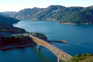
Lake Sonoma is a reservoir west of Cloverdale in northern Sonoma County, California, created by the construction of Warm Springs Dam. The lake provides water for countywide growth and development, and for recreation.

Hartwell Dam is a concrete and embankment dam located on the Savannah River at the border of South Carolina and Georgia, creating Lake Hartwell. The dam was built by the U.S. Army Corps of Engineers between 1955 and 1962 for the purposes of flood control, hydropower and navigation. The concrete and earthen structure spans 15,840 feet (4,828 m). The concrete section is 1,900 feet (579 m) long and rises 204 feet (62 m) above the riverbed at its apex. The Hartwell Dam currently produces 468 million KWh of electricity annually, has prevented over $40 million in flood damage since completion and also provides recreation, water quality, water supply, along with fish and wildlife management.

Isabella Dam is an embankment dam located in the Kern River Valley, about halfway down the Kern River course, between the towns of Kernville and Lake Isabella in Kern County, California.

Optima Lake was built to be a reservoir in Texas County, Oklahoma. The site is just north of Hardesty and east of Guymon in the Oklahoma Panhandle.

The Cochiti Dam is an earthen fill dam located on the Rio Grande in Sandoval County, New Mexico, approximately 50 miles (80 km) north of Albuquerque, New Mexico, in the United States. By volume of material, it is the 23rd largest dam in the world at 62,849,000 yd3 of material, one of the ten largest such dams in the United States, and the eleventh largest such dam in the world. Cochiti Dam is one of the four United States Army Corps of Engineers projects for flood and sediment control on the Rio Grande system, operating in conjunction with Abiquiu Dam, Galisteo Dam and Jemez Canyon Dam.

Folsom Dam is a concrete gravity dam on the American River of Northern California in the United States, about 25 mi (40 km) northeast of Sacramento. The dam is 340 ft (100 m) high and 1,400 ft (430 m) long, flanked by earthen wing dams. It was completed in 1955, and officially opened the following year.
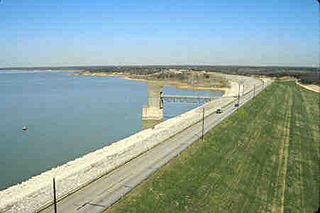
Grapevine Lake is a reservoir in North Texas about 20 mi (32 km) northwest of Dallas and northeast of Fort Worth. It was impounded in 1952 by the U.S. Army Corps of Engineers when they dammed Denton Creek, a tributary of Trinity River.

Mansfield Hollow Lake is a reservoir resting on the border of Windham County and Tolland County, Connecticut. The reservoir provides drinking water for Willimantic and helps control flooding in the 159-square-mile Thames River watershed. It was created by the Mansfield Hollow Dam and is entirely contained within Mansfield Hollow State Park and the Mansfield Hollow Wildlife Area. Designed and constructed by the United States Army Corps of Engineers, the dam substantially reduces flooding along the Quinebaug, Shetucket, and Thames rivers. Construction of the project began in 1949 with completion in 1952 at a cost of US$6.5 million. The Mansfield Hollow reservoir is located within the Shetucket River Watershed and is part of the Thames River Basin. Access to the site is available from US Route 6 and State Route 195. The damsite, covering an area of 25 acres (10 ha), was listed on the National Register of Historic Places in 2003.
Overhills is an unincorporated community located in the Johnsonville Township of Harnett County, North Carolina, United States, near the Cumberland County town of Spring Lake. It is a part of the Dunn Micropolitan Area, which is also a part of the greater Raleigh–Durham–Cary Combined Statistical Area (CSA) as defined by the United States Census Bureau.

Santa Fe Dam is a flood-control dam on the San Gabriel River located in Irwindale in Los Angeles County, California, United States. For most of the year, the 92-foot (28 m)-high dam and its reservoir lie empty, but can hold more than 45,000 acre-feet (56,000,000 m3) of water during major storms. During the dry season, the basin behind the dam is used for groundwater recharge, as well as various recreational activities.
Pokegama Lake Dam is a dam in Cohasset, Itasca County, Minnesota, northwest of the city of Grand Rapids.

The St. Lucie Canal, also known as the C-44 Canal or simply C-44, is a man-made canal in Martin County, Florida, connecting Lake Okeechobee to the Indian River Lagoon. The canal was built between 1916 and 1924 to divert floodwaters from the lake into the St. Lucie Estuary via the South Fork of the St. Lucie River. Deepened in 1937 to enable the passage of boats, the St. Lucie Canal is now the eastern segment of the Okeechobee Waterway.


