The McArthur Lake Wildlife Corridor (MLWC) is a wildlife corridor in northern Idaho, United States. It links the wilderness areas of the Selkirk and Cabinet mountains, and is used by species such as grizzly bears that move between these areas. It also provides a wintering area for deer and other ungulates. A highway and two railway lines run through the corridor, with a strip of side roads, buildings and fences along the highway. The highway section running through the corridor has high rates of vehicle collisions with wildlife. There is limited opportunity for creating safe wildlife crossings due to the difficult terrain. Conservation groups have been active in obtaining easements on timber land to prevent further development in the corridor while allowing sustainable forestry.
Highway 2/95 from Sandpoint to Bonners Ferry runs through the corridor.[4] The corridor is also crossed by the Union Pacific Railroad and the Burlington Northern Santa Fe Railway.[5] The corridor's concentration area extends along the highway for approximately 11 miles (18km). Development for about 1 mile (1.6km) on each side of the highway includes buildings, fences, roads and driveways.[5] The many access roads along this stretch of the highway make fencing difficult.[6]
Environment
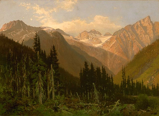
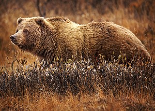
McArthur Lake Wildlife Corridor is in a scenic area of Idaho.[7] It contains conifer forests, forested or shrub wetlands and swamps, streams and rivers.[8] The high-quality cold water streams are home to the only populations of interior redband trout known in Idaho, and are key to recovery of the threatened bull trout.[9] Animals that migrate through the corridor include American black bear (Ursus americanus), Canada lynx (Lynx canadensis), elk (Cervus canadensis), gray wolf (Canis lupus), grizzly bear (Ursus arctos horribilis), moose (Alces americanus), white-tailed deer (Odocoileus virginianus) and wolverine (Gulo gulo).[8] The corridor supports six species that are federally listed or candidates to be considered threatened or endangered, and many others that are rare and sensitive.[10]
As well as being a linkage area between the Selkirk and Cabinet Mountains the MLWC provides a winter range for moose and white-tailed deer. In the spring and early summer it is a natal area for several species of ungulate, who are at risk as they move around and cross the highway. In the summer it is more important for grizzlies. In fall and winter it is a residence area for ungulates.[6] The corridor is known as an excellent area for hunting and fishing. Hunters target elk, mule deer, moose, white-tailed deer, black bear, mountain lion, waterfowl and upland game birds.[9] The public also uses the corridor for hiking and berry picking.[7]
Vehicle collisions
Idaho panhandle. The corridor is in the north at the narrowest point between the orange forest areas to the east and west of the highway.
The area has the greatest number of collisions with wildlife in Idaho.[11] The animals move down to lower land in the winter, taking them to the Highway 95 area, called the "McArthur Killing Fields" by an employee of the Idaho Department of Transportation.[12] In the winter of 1996 northern Idaho received an exceptional 19 feet (5.8m) of snow, which forced deer, elk and moose to move down to the area around Route 95. The animals could easily cross the 2 feet (0.61m) snow banks, but became confused and vulnerable on the icy highway. At least 200 deer were killed by collisions with cars that winter, as well as a few moose and elk.[5] As of 2009 about 6,600 vehicles crossed the wildlife corridor daily on the highway. It was the top place for wildlife collisions in the state, with 34 collisions in 2007.[12] Animals other than birds killed by vehicles are, in order of frequency, white-tailed deer, turtles, otter, moose, elk and wolverine.[12]
At one stage there was funding for an underpass in the concentration area of the corridor, but for various reasons this was lost. When the culvert at the McArthur Lake Dam on Deep Creek is replaced by a bridge, that would be used to provide a passageway for wildlife. To the south of the culvert the topography and high water table make it difficult to install structures for wildlife crossings.[12]
The National Fish and Wildlife Foundation (NFWF) under its Cabinet Yaak Wildlife Corridors program has given funding to The Nature Conservancy to provide safer passage of people and wildlife in the corridor.[13] In January 2012 the NWFW granted $99,268 towards the McArthur Lake Wildlife Safety Project, which would attempt to reduce collisions between wildlife and vehicles on Highway 95 near Bonners Ferry. The Nature Conservancy was to match the Foundation funds, and to work with the Kootenai Valley Resource Initiative to implement the improvements, which would be selected based on cost-benefit analysis. These could include wildlife fencing and systems to detect animals and alert motorists.[11]
Protection efforts
In December 2010 it was reported that Walmart had donated $1 million to The Nature Conservancy to protect two recovery zones for grizzly bears and habitat for over twenty species of high conservation need in the 3,727 acres (1,508ha) McArthur Lake Wildlife Corridor.[14] On 11 July 2013 The U.S. Forest Service announced a $4.1 million award to acquire a 6,847 acres (2,771ha) conservation easement from Stimson Lumber Company within and adjoining the McArthur Lake Wildlife Corridor.[10] The checkerboard forest property was the largest single property in the MLWC to remain unprotected.[9]
In September 2016 about 5,568 acres (2,253ha) of forest to the east of McArthur Lake between Sandpoint and Bonners Ferry was placed under conservation easements, which compensate landowners for limiting uses such as development and subdivision, but allow sustainable forestry to continue. They would benefit wildlife, help local economies, improve water quality and support recreation. Funding was by Forest Legacy Funds, which come from the Land and Water Conservation Fund. This receives royalties from energy companies in return for permission to drill for oil and gas on the Outer Continental Shelf. The Idaho Department of Lands (IDL) obtained the easements through partnership between the Molpus Woodlands Group, the Idaho Department of Fish and Game, The Nature Conservancy and the United States Forest Service.[7]
In April 2018 it was announced that 5,000 acres (2,000ha) of forest near Bonners Ferry would be placed under conservation easements. Half of the land was near Hall Mountain and half was in the McArthur Lake Wildlife Corridor east of McArthur Lake. Public access for hunting, hiking and berry picking would still be allowed.[15]
The moose or elk is a member of the New World deer subfamily and is the only species in the genus Alces. It is the largest and heaviest extant species in the deer family. Most adult male moose have distinctive broad, palmate antlers; most other members of the deer family have antlers with a dendritic ("twig-like") configuration. Moose typically inhabit boreal forests and temperate broadleaf and mixed forests of the Northern Hemisphere in temperate to subarctic climates. Hunting and other human activities have caused a reduction in the size of the moose's range over time. It has been reintroduced to some of its former habitats. Currently, most moose occur in Canada, Alaska, New England, New York State, Fennoscandia, the Baltic states, Poland, Kazakhstan, and Russia.
The Selkirk Mountains are a mountain range spanning the northern portion of the Idaho Panhandle, eastern Washington, and southeastern British Columbia which are part of a larger grouping of mountains, the Columbia Mountains. They begin at Mica Peak and Krell Hill near Spokane and extend approximately 320 km north from the border to Kinbasket Lake, at the now-inundated location of the onetime fur company post Boat Encampment. The range is bounded on its west, northeast and at its northern extremity by the Columbia River, or the reservoir lakes now filling most of that river's course. From the Columbia's confluence with the Beaver River, they are bounded on their east by the Purcell Trench, which contains the Beaver River, Duncan River, Duncan Lake, Kootenay Lake and the Kootenay River. The Selkirks are distinct from, and geologically older than, the Rocky Mountains. The neighboring Monashee and Purcell Mountains, and sometimes including the Cariboo Mountains to the northwest, are also part of the larger grouping of mountains known as the Columbia Mountains. A scenic highway loop, the International Selkirk Loop, encircles the southern portions of the mountain range.
Wildlife crossings are structures that allow animals to cross human-made barriers safely. Wildlife crossings may include underpass tunnels or wildlife tunnels, viaducts, and overpasses or green bridges ; amphibian tunnels; fish ladders; canopy bridges ; tunnels and culverts ; and green roofs.
Lake Pend Oreille in the northern Idaho Panhandle is the largest lake in the U.S. state of Idaho and the 38th-largest lake by area in the United States, with a surface area of 148 square miles (380 km2). It is 43 miles (69 km) long, and 1,150 feet (350 m) deep in some regions, making it the fifth-deepest in the nation and having a volume of 43,939,940 acre feet = 54 km3. The lake is fed by the Clark Fork River and the Pack River, and drains into the Pend Oreille River, as well as subsurfacely into the Spokane Valley–Rathdrum Prairie Aquifer. It is surrounded by national forests and a few small towns, with the largest population on the lake at Sandpoint. The majority of the shoreline is non-populated and all but the southern tip of the lake is in Bonner County. The southern tip is in Kootenai County and is home to Farragut State Park, formerly the Farragut Naval Training Station during World War II, of which a small part is still active and conducts U.S. Navy acoustic underwater submarine research.
The Pack River is a medium-sized river located in Northern Idaho. It is about 40 miles (64 km) long and drains a high mountainous area of the Idaho Panhandle's Rocky Mountains and Selkirk Mountains. The river flows into Lake Pend Oreille and is part of the Columbia River watershed via the Pend Oreille River.
Bitterroot National Forest comprises 1.587 million acres (6,423 km²) in west-central Montana and eastern Idaho, of the United States. It is located primarily in Ravalli County, Montana, but also has acreage in Idaho County, Idaho (29.24%), and Missoula County, Montana (0.49%).
Caribou–Targhee National Forest is located in the states of Idaho and Wyoming, with a small section in Utah in the United States. The forest is broken into several separate sections and extends over 2.63 million acres (10,600 km2). To the east the forest borders Yellowstone National Park, Grand Teton National Park and Bridger–Teton National Forest. Most of the forest is a part of the 20-million-acre (81,000 km2) Greater Yellowstone Ecosystem.
The Idaho Panhandle National Forests are a jointly administered set of three national forests located mostly in the U.S. state of Idaho. In 1973, major portions of the Kaniksu, Coeur d'Alene, and St. Joe National Forests were combined to be administratively managed as the Idaho Panhandle National Forests (IPNF). The IPNF consists of more than 2.5 million acres (10,000 km2) of public lands in the panhandle of north Idaho, with small areas extending into eastern Washington (4.7%) and western Montana (1.2%). The northernmost portion of the IPNF share a boundary with Canada. The Forest Supervisor's office is located in Coeur d'Alene, Idaho with district office's in Bonners Ferry, Sandpoint, Priest River, Fernan and Smelterville, and St. Maries and Avery.
The Cabinet Mountains are part of the Rocky Mountains, located in northwest Montana and the Idaho panhandle, in the United States. The mountains cover an area of 2,134 square miles (5,527 km2). The Cabinet Mountains lie south of the Purcell Mountains, between the Kootenai River and Clark Fork River and Idaho's Lake Pend Oreille. The Cabinet Mountains lie to the east of the Purcell Trench. The Cabinet Mountains form the north side of the Clark Fork River valley in Idaho and Montana. The Cabinet Mountains Wilderness is located east of the Bull River near Noxon, Montana in roughly the center of the range.
Salmo-Priest Wilderness is a 41,335 acre (167.28 km2) wilderness area located in the Selkirk Mountains in the northeast corner of Washington state, within the Colville National Forest and the Kaniksu National Forest.
The Kootenai National Wildlife Refuge is a National Wildlife Refuge of the United States located in northern Idaho. It is about 20 miles (32 km) from the Canada–United States border and 5 miles (8.0 km) from the town of Bonners Ferry. It is bordered by the Selkirk Mountains to the west, the Kootenai River to the east, and state lands to the south.
The ecology of the Rocky Mountains is diverse due to the effects of a variety of environmental factors. The Rocky Mountains are the major mountain range in western North America, running from the far north of British Columbia in Canada to New Mexico in the southwestern United States, climbing from the Great Plains at or below 1,800 feet (550 m) to peaks of over 14,000 feet (4,300 m). Temperature and rainfall varies greatly also and thus the Rockies are home to a mixture of habitats including the alpine, subalpine and boreal habitats of the Northern Rocky Mountains in British Columbia and Alberta, the coniferous forests of Montana and Idaho, the wetlands and prairie where the Rockies meet the plains, a different mix of conifers on the Yellowstone Plateau in Wyoming and in the high Rockies of Colorado and New Mexico, and finally the alpine tundra of the highest elevations.
The South Central Rockies forests is a temperate coniferous forest ecoregion of the United States located mainly in Wyoming, Idaho, and Montana. It has a considerably drier climate than the North Central Rockies forest.
The North Central Rockies forests is a temperate coniferous forest ecoregion of Canada and the United States. This region overlaps in large part with the North American inland temperate rainforest and gets more rain on average than the South Central Rockies forests and is notable for containing the only inland populations of many species from the Pacific coast.
The grizzly bear, also known as the North American brown bear or simply grizzly, is a population or subspecies of the brown bear inhabiting North America.
McArthur Lake Wildlife Management Area at 1,207 acres (4.88 km2) is an Idaho wildlife management area in Bonner and Boundary counties located between Sandpoint and Bonners Ferry. It was established in 1942 to protect and enhance waterfowl habitat. It lies within the McArthur Lake Wildlife Corridor.
Operating as a nonprofit environmental land trust, The Vital Ground Foundation protects and restores North America's grizzly bear populations by conserving wildlife habitat. Founded in 1990, Vital Ground operates in the belief that the grizzly bear, an umbrella species, is nature's barometer of a healthy and complete ecosystem, and that conserving grizzly bears and their habitat is key to ensuring diverse and healthy landscapes.
Douglas H. Chadwick is an American wildlife biologist, author, photographer and frequent National Geographic contributor. He is the author of fourteen books and more than 200 articles on wildlife and wild places.
McArthur Lake is a reservoir in Boundary County, Idaho, USA. It gives its name to the McArthur Lake Wildlife Corridor, which provides a bridge for wildlife to migrate between two mountainous areas. The reservoir and surrounding wetlands are rich in bird life, and are protected by the McArthur Lake Wildlife Management Area. There has been discussion about removing the dam that impounds the reservoir, which would improve the wetlands so they would support larger numbers of game birds, and would also improve the quality of water downstream.
Elected officials in Jackson, Wyoming, have added a proposal to the November 2019 ballot for a special-purpose excise tax to fund wildlife crossings. If the ballot initiative passes, it will fund proposed wildlife crossings in accordance with the Teton County Wildlife Crossing Master Plan.
This page is based on this Wikipedia article Text is available under the CC BY-SA 4.0 license; additional terms may apply. Images, videos and audio are available under their respective licenses.