McDonald Islands

Last updated
McDonald Islands
Highest point
Elevation 230 m (750 ft)
Geography
Location Heard Island and McDonald Islands, Australia
Geology
Mountain type Complex volcano
Last eruption July 2005
Indian Ocean laea relief location map.jpg
Red pog.svg
McDonald Islands
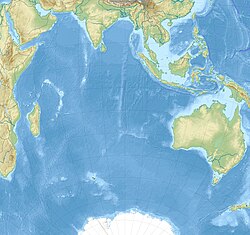
Location in the Indian Ocean
Map of Heard Island and McDonald Islands Heard Island and McDonald Islands-CIA WFB Map.png
Map of Heard Island and McDonald Islands
McDonald Islands
McDonald Island

The McDonald Islands ( 53°3′34.9″S72°35′32.2″E / 53.059694°S 72.592278°E / -53.059694; 72.592278 ) is an uninhabited archipelago in the southern Indian Ocean in the vicinity of Heard Island ( 53°06′S73°31′E / 53.100°S 73.517°E / -53.100; 73.517 ). Together with Heard Island, they make up the Australian external territory of Heard Island and McDonald Islands. The McDonald Islands are the emergent peaks of submarine volcanoes and are Australian external territory. Prior to 1992, there had not been an eruption in the previous 75,000 years.

Contents

In 2024, it got some notoriety thanks to an intrigue between two fast food giants, McDonald's and Burger King. The latter wants to change the island name to Ilha Whopper (Whopper Island), affirming that "A place with real fire can't be named McDonald's". [1]

Morphology

The McDonald Islands comprise three islands: McDonald Island, Flat Island (which later merged with McDonald Island) and Meyer Rock. The islands are mostly composed of phonolitic low-silica pumice, dikes and lava domes, and sit atop a submarine plateau, the Kerguelen Plateau. They are located about 75 km from Heard Island.

McDonald Island is the largest of the islands, at around 1 square kilometre (250 acres) in area. It has been the main focus of volcanic activity in recent times. Prior to 1996, McDonald Island had been a flat green island whose pumice beaches provided a great nesting area for penguin breeding. The island now has two main peaks, Maxwell Hill and Samarang Hill the highest is Maxwell Hill at 230 metres (750 ft).

Eruptions

Prior to 1992, no eruptions had taken place at the McDonald Islands volcano for 75,000 years. A series of eruptions started in 1992.

1992 eruption

The first recorded eruption from the McDonalds was from a submarine vent (a small VEI-0 eruption) in December 1992. The eruption was probably the cause of pumice that washed up on the shore of Heard Island.

1996–1997 eruption

Fresh eruptions were reported in December 1996 when a vapour plume was noticed by an aeroplane pilot.

The plume was thought to have originated from Heard Island's Big Ben cone. However, on 18 March 1997 the crew of a passing ship heading for Heard Island reported that steam rose vigorously from a fissure on McDonald Island's steep north face; steam also vented from the island's north summit. Steam vented from a rubble-covered slope, indicating that a lava flow or pyroclastic flow had occurred.

On 2 April 1997, the crew of another ship noted that steam continued to vent from the fissure, rising from the summit and flanks of the island. That crew also observed lava flows travelling down gullies; the lava flows covered a significant area of the north part of the island. Sulphur deposits were also discovered and fresh pumice washed up on Heard Island. The eruption is estimated to have ended sometime in January–March 1997.

2001 eruption

Another eruption started at McDonald Island in 2001. The eruption was first sighted from a ship passing by the islands. Material was being ejected from the flanks of the island and also in the north and northwest of the island, and steam was issuing from near the summit crater. Work suggested that prior to the ship's visit, the volcano had been erupting, covering the island in dark, smooth material. Many features had been filled in, such as Williams Bay. The eruptions had also joined Flat Island to McDonald Island as 400 metres (1,300 ft) of land had been added to windward point. A new volcanic cone had also been created. An observation made in November 2002 noted two new lava domes had been formed; their date of formation is unknown.

2005 eruption

Analysis of satellite imagery noted that an eruption took place on 12 July 2005 on the northwest shore of the island. The eruption may have added a small portion to the area of the island.

Heritage

In 2002 the Heard Island and McDonald Islands were declared a marine reserve; this was expanded in 2014. [2] The islands are also recognised as a World Heritage Site. [3]

Notes

  1. "Ilha Whopper: Burger King quer mudar nome de ilha para provocar McDonald's". UOL (in Brazilian Portuguese). 2024-01-16. Retrieved 2024-01-21.
  2. "Heard Island and McDonald Islands Marine Reserve Expansion". www.antarctica.gov.au. 2014-03-29. Retrieved 2023-07-03.
  3. "World heritage". www.antarctica.gov.au. 2022-09-29. Retrieved 2023-07-03.

Related Research Articles

<span class="mw-page-title-main">Volcano</span> Rupture in a planets crust where material escapes

A volcano is a rupture in the crust of a planetary-mass object, such as Earth, that allows hot lava, volcanic ash, and gases to escape from a magma chamber below the surface.

<span class="mw-page-title-main">Mono–Inyo Craters</span> Volcanic chain in eastern California, United States

The Mono–Inyo Craters are a volcanic chain of craters, domes and lava flows in Mono County, Eastern California. The chain stretches 25 miles (40 km) from the northwest shore of Mono Lake to the south of Mammoth Mountain. The Mono Lake Volcanic Field forms the northernmost part of the chain and consists of two volcanic islands in the lake and one cinder cone volcano on its northwest shore. Most of the Mono Craters, which make up the bulk of the northern part of the Mono–Inyo chain, are phreatic volcanoes that have since been either plugged or over-topped by rhyolite domes and lava flows. The Inyo volcanic chain form much of the southern part of the chain and consist of phreatic explosion pits, and rhyolitic lava flows and domes. The southernmost part of the chain consists of fumaroles and explosion pits on Mammoth Mountain and a set of cinder cones south of the mountain; the latter are called the Red Cones.

<span class="mw-page-title-main">Newberry Volcano</span> Shield volcano in Oregon, United States

Newberry Volcano is a large active shield-shaped stratovolcano located about 20 miles (32 km) south of Bend, Oregon, United States, 35 miles (56 km) east of the major crest of the Cascade Range, within the Newberry National Volcanic Monument. Its highest point is Paulina Peak. The largest volcano in the Cascade Volcanic Arc, Newberry has an area of 1,200 square miles (3,100 km2) when its lava flows are taken into account. From north to south, the volcano has a length of 75 miles (121 km), with a width of 27 miles (43 km) and a total volume of approximately 120 cubic miles (500 km3). It was named for the geologist and surgeon John Strong Newberry, who explored central Oregon for the Pacific Railroad Surveys in 1855.

<span class="mw-page-title-main">Cerro Negro</span> Active volcano in Nicaragua

Cerro Negro is an active volcano in the Cordillera de los Maribios mountain range in Nicaragua, about 10 km (6.2 mi) from the village of Malpaisillo. It is a very new volcano, the youngest in Central America, having first appeared in April 1850. It consists of a gravelly basaltic cinder cone, which contrasts greatly with the surrounding verdant hillsides, and gives rise to its name, which means Black Hill. Cerro Negro has erupted frequently since its first eruption. One unusual aspect of several eruptions has been the emission of ash from the top of the cone, while lava erupts from fractures at the base.

<span class="mw-page-title-main">Puʻu ʻŌʻō</span> Volcanic cone in the Hawaiian Islands

Puʻu ʻŌʻō is a volcanic cone on the eastern rift zone of Kīlauea volcano in the Hawaiian Islands. The eruption that created Puʻu ʻŌʻō began on January 3, 1983, and continued nearly continuously until April 30, 2018, making it the longest-lived rift-zone eruption of the last two centuries.

<span class="mw-page-title-main">Hawaiian eruption</span> Effusive volcanic eruption

A Hawaiian eruption is a type of volcanic eruption where lava flows from the vent in a relatively gentle, low level eruption; it is so named because it is characteristic of Hawaiian volcanoes. Typically they are effusive eruptions, with basaltic magmas of low viscosity, low content of gases, and high temperature at the vent. Very small amounts of volcanic ash are produced. This type of eruption occurs most often at hotspot volcanoes such as Kīlauea on Hawaii's big island and in Iceland, though it can occur near subduction zones and rift zones. Hawaiian eruptions may occur along fissure vents, such as during the eruption of Mauna Loa in 1950, or at a central vent, such as during the 1959 eruption in Kīlauea Iki Crater, which created a lava fountain 580 meters (1,900 ft) high and formed a 38-meter cone named Puʻu Puaʻi. In fissure-type eruptions, lava spurts from a fissure on the volcano's rift zone and feeds lava streams that flow downslope. In central-vent eruptions, a fountain of lava can spurt to a height of 300 meters or more.

<span class="mw-page-title-main">Submarine volcano</span> Underwater vents or fissures in the Earths surface from which magma can erupt

Submarine volcanoes are underwater vents or fissures in the Earth's surface from which magma can erupt. Many submarine volcanoes are located near areas of tectonic plate formation, known as mid-ocean ridges. The volcanoes at mid-ocean ridges alone are estimated to account for 75% of the magma output on Earth. Although most submarine volcanoes are located in the depths of seas and oceans, some also exist in shallow water, and these can discharge material into the atmosphere during an eruption. The total number of submarine volcanoes is estimated to be over one million of which some 75,000 rise more than 1 kilometre (0.62 mi) above the seabed. Only 119 submarine volcanoes in Earth's oceans and seas are known to have erupted during the last 11,700 years.

<span class="mw-page-title-main">Mount Pico</span> Volcano in the Azores, Portugal

Mount Pico is a currently quiescent stratovolcano located on Pico Island, in the mid-Atlantic archipelago of the Azores. It is the highest mountain in Portugal, at 2,351 metres (7,713 ft) above sea level, and is one of the highest Atlantic mountains; it is more than twice the elevation of any other peak in the Azores. It has been a designated nature reserve since 1972.

<span class="mw-page-title-main">Types of volcanic eruptions</span> Overview of different types of volcanic eruptions

Several types of volcanic eruptions—during which material is expelled from a volcanic vent or fissure—have been distinguished by volcanologists. These are often named after famous volcanoes where that type of behavior has been observed. Some volcanoes may exhibit only one characteristic type of eruption during a period of activity, while others may display an entire sequence of types all in one eruptive series.

<span class="mw-page-title-main">Volcanic plateau</span> Plateau produced by volcanic activity

A volcanic plateau is a plateau produced by volcanic activity. There are two main types: lava plateaus and pyroclastic plateaus.

<span class="mw-page-title-main">Chain of Craters Road</span> Road in Hawaii

Chain of Craters Road is a 19-mile (31 km) long winding paved road through the East Rift and coastal area of the Hawaii Volcanoes National Park on the island of Hawaii, in the state of Hawaii, United States. The original road, built in 1928, connected Crater Rim Drive to Makaopuhi Crater. The road was lengthened to reach the tiny town of Kalapana in 1959. As of 2018, the road has had parts covered by lava in 41 of the past 53 years, due to eruptions of Kīlauea volcano.

<span class="mw-page-title-main">Mount Gareloi</span> Stratovolcano in the Aleutian Islands of Alaska, U.S.

Mount Gareloi, or Gareloi Volcano, is a stratovolcano in the Aleutian Islands of Alaska, United States, about 1,259 miles (2,026 km) from Anchorage. Gareloi is located on Gareloi Island, and comprises most of its land mass. The island also has two small glaciers which protrude to the northwest and southeast.

<span class="mw-page-title-main">Puyehue-Cordón Caulle</span> Volcanic complex in Chile

Puyehue and Cordón Caulle are two coalesced volcanic edifices that form a major mountain massif in Puyehue National Park in the Andes of Ranco Province, in the South of Chile. In volcanology this group is known as the Puyehue-Cordón Caulle Volcanic Complex (PCCVC). Four volcanoes constitute the volcanic group or complex, the Cordillera Nevada caldera, the Pliocene Mencheca volcano, Cordón Caulle fissure vents and the Puyehue stratovolcano.

<span class="mw-page-title-main">2011–12 El Hierro eruption</span> Submarine volcanic eruption near the Canary Islands

The 2011–2012 El Hierro eruption occurred just off the island of El Hierro, the smallest and farthest south and west of the Canary Islands, in the Atlantic Ocean off the coast of Africa. The island is also the youngest in the volcanic chain. The October 2011 – March 2012 eruption was underwater, with a fissure of vents located approximately 2 kilometres to the south of the fishing village of La Restinga on the southern coast of the island. Increased seismicity in June 2012 to the north-west of the vent did not result in another phase of eruptive activity. Until the 2021 La Palma eruption, which started on 19 September 2021, this was the last volcanic eruption in Spain.

<span class="mw-page-title-main">Niigata-Yakeyama</span> Active volcano on the island of Honshu, Japan

Niigata-Yake-Yama is an active volcano in Honshu, Japan. A large eruption in 887 AD sent pyroclastic flows all the way to the Japan Sea.

Macdonald seamount is a seamount in Polynesia, southeast of the Austral Islands and in the neighbourhood of a system of seamounts that include the Ngatemato seamounts and the Taukina seamounts. It rises 4,200 metres (13,800 ft) from the seafloor to a depth of about 40 metres (130 ft) and has a flat top, but the height of its top appears to vary with volcanic activity. There are some subsidiary cones such as Macdocald seamount. The seamount was discovered in 1967 and has been periodically active with gas release and seismic activity since then. There is hydrothermal activity on Macdonald, and the vents are populated by hyperthermophilic bacteria.

<span class="mw-page-title-main">2018 lower Puna eruption</span> Volcanic eruption on Hawaiʻi Island

The 2018 lower Puna eruption was a volcanic event on the island of Hawaiʻi, on Kīlauea volcano's East Rift Zone that began on May 3, 2018. It is related to the larger eruption of Kīlauea that began on January 3, 1983, though some volcanologists and USGS scientists have discussed whether to classify it as a new eruption. Outbreaks of lava fountains up to 300 feet (90 m) high, lava flows, and volcanic gas in the Leilani Estates subdivision were preceded by earthquakes and ground deformation that created cracks in the roads.

<span class="mw-page-title-main">Lava balloon</span> Floating bubble of lava

A lava balloon is a gas-filled bubble of lava that floats on the sea surface. It can be up to several metres in size. When it emerges from the sea, it is usually hot and often steaming. After floating for some time it fills with water and sinks again.

<span class="mw-page-title-main">1984 eruption of Mauna Loa</span>

The 1984 eruption of Mauna Loa was a Hawaiian eruption in the U.S. state of Hawaii that lasted from March 25 to April 15, 1984. It ended a 9-year period of quiescence at the volcano and continued for 22 days, during which time lava flows and lava fountains issued from the summit caldera and fissures along the northeast and southwest rift zones. Although the lava threatened Hilo, the flow stopped before reaching the outskirts of town.

<span class="mw-page-title-main">NW Rota-1</span> Seamount in the United States of America

NW Rota-1 is a seamount in the Mariana Islands, northwest of Rota, which was discovered through its hydrothermal activity in 2003. The volcano has been observed to be erupting underwater, the first time that submarine explosive eruptions have been directly witnessed.

References