Related Research Articles

Thurston Island is a largely ice-covered, glacially dissected island, 135 nautical miles long and 55 nautical miles wide, lying between Amundsen Sea and Bellingshausen Sea a short way off the northwest end of Ellsworth Land, Antarctica. The island is separated from the mainland by Peacock Sound, which is occupied by the west portion of Abbot Ice Shelf.
The Tapley Mountains is a range of mountains fronting on the eastern side of the Scott Glacier, extending eastward for 35 nautical miles between Leverett Glacier and Albanus Glacier in the Queen Maud Mountains of Antarctica.
The Cook Mountains is a group of mountains bounded by the Mulock and Darwin glaciers in Antarctica. They are south of the Worcester Range and north of the Darwin Mountains and the Britannia Range.

The Usarp Mountains are a major mountain range in North Victoria Land, Antarctica. They are west of the Rennick Glacier and trend north to south for about 190 kilometres (118 mi). The mountains are bounded to the north by Pryor Glacier and the Wilson Hills. They are west of the Bowers Mountains.
Fortuna Bay is a bay 3 miles (5 km) long and 1 mile (1.6 km) wide. Its entrance is defined by Cape Best on the west and Robertson Point to the east, near Atherton Peak on the north coast of South Georgia. It was named after the Fortuna, one of the ships of the Norwegian–Argentine whaling expedition under C.A. Larsen which participated in establishing the first permanent whaling station at Grytviken, South Georgia, in 1904–05. The Second German Antarctic Expedition (SGAE) under Wilhelm Filchner explored Fortuna Bay in 1911–12. Discovery Investigations (DI) personnel charted the area during their 1929–30 expedition.
Jason Harbour is a bay 1 mile (1.6 km) wide, lying west of Allen Bay in the north side of Cumberland West Bay, South Georgia. It was charted and named by the Swedish Antarctic Expedition, 1901–04, under Otto Nordenskiöld. The bay was previously visited by the Jason, Captain C.A. Larsen, in 1894.

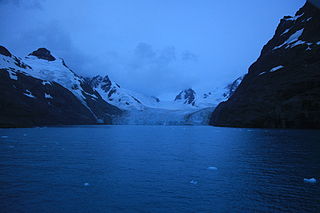
Moraine Fjord is an inlet 3.5 nautical miles long with a reef extending across its entrance, forming the west head of Cumberland East Bay, South Georgia. It was charted by the Swedish Antarctic Expedition under Otto Nordenskjöld, 1901–04, who so named it because of the large glacial moraine at its entrance.

Larsen Harbour is a narrow 2.6 miles (4.2 km) long inlet of indenting volcanic rocks and sheeted dykes known as the Larsen Harbour Formation. It is a branch of Drygalski Fjord, entered 2.5 miles (4 km) west-northwest of Nattriss Head, at the southeast end of South Georgia Island. It was charted by the Second German Antarctic Expedition, 1911–12, under Filchner, who named it for Captain Carl Anton Larsen a Norwegian explorer, who made significant contributions to the exploration of Antarctica. The most significant of these was the first discovery of fossils on the continent, for which he received the Back Grant from the Royal Geographical Society. Larsen is also considered the founder of the Antarctic whaling industry and the settlement and whaling station of Grytviken, South Georgia.
Harmer Glacier is a glacier 3 nautical miles (6 km) long, flowing southwest from Starbuck Peak to the sea close north of Ranvik, on the south coast of South Georgia. It was surveyed by the South Georgia Survey in the period 1951–57, and named by the UK Antarctic Place-Names Committee for Sir Sidney F. Harmer.
Jenkins Glacier is a glacier close south of Risting Glacier, flowing east into the head of Drygalski Fjord in the southeastern part of South Georgia. The glacier was named for Erich von Drygalski by the Second German Antarctic Expedition, 1911–12, under Wilhelm Filchner. To avoid duplication with Drygalski Glacier in Graham Land, also named for Erich von Drygalski, a new name was proposed in 1957 by the UK Antarctic Place-Names Committee. Jenkins Glacier is named for James Travis Jenkins, author of A History of the Whale Fisheries and Bibliography of Whaling.
Risting Glacier is a glacier, 4.5 nautical miles (8 km) long, lying north of Jenkins Glacier and flowing southeast into the head of Drygalski Fjord in the south part of South Georgia. Surveyed by the South Georgia Survey (SGS) under Duncan Carse in the period 1951–57, and named by the United Kingdom Antarctic Place-Names Committee (UK-APC) for Sigurd Risting (1870-1935), Norwegian whaling historian; secretary of Norsk Hvalfangerforening, 1918–35, and editor of Norsk Hvalfangst-Tidende, 1922–35. The German Antarctic Expedition under Wilhelm Filchner, 1911–12, named Drygalski Fjord and this glacier for Erich von Drygalski, leader of the German Antarctic Expedition, 1901–03, but the name for the glacier did not survive. A number of features in Antarctica, including Drygalski Glacier, are named for Drygalski.
Barwick Valley is an ice-free valley north of Apocalypse Peaks, extending from Webb Glacier to Victoria Valley in Victoria Land, Antarctica. A large part of the valley has been designated an Antarctic Specially Protected Area because of its pristine condition.
The Cornwall Peaks are two conspicuous rock peaks, the higher reaching 960 metres (3,150 ft), standing at the west side of König Glacier, 2.5 nautical miles (5 km) southwest of Fortuna Bay, South Georgia. The name Cornwall Peak was probably given by Discovery Investigations personnel during their survey of Fortuna Bay in 1929. During the South Georgia Survey, 1951–52, this peak could not be re-identified. At the same time it was reported that the features now described, although lying farther south, together form a conspicuous landmark requiring a name. The name Cornwall Peaks was recommended for these peaks by the UK Antarctic Place-Names Committee in 1954, and the name "Cornwall Peak" (singular) has been eliminated.

Funk Glacier is a glacier flowing into the head of Nevsha Cove in Beascochea Bay to the south of Frölich Peak, on the west coast of Graham Land, Antarctica. It was first charted by the French Antarctic Expedition, 1908–10, under Jean-Baptiste Charcot. It was named by the UK Antarctic Place-Names Committee in 1959 for Casimir Funk, an American biochemist who, while working at the Lister Institute in London in 1912, originated the theory of vitamins.
Douglas Crag is a crag, 1,670 metres (5,480 ft) high, standing 1 nautical mile (2 km) southeast of Mount Macklin at the south end of the Salvesen Range of South Georgia. It was surveyed by the South Georgia Survey in the period 1951–57, and named by the UK Antarctic Place-Names Committee for George V. Douglas, a geologist with the British expedition under Ernest Shackleton, 1921–22.
Foxtail Peak is a peak, 455 metres (1,500 ft) high, on the north side of Neumayer Glacier, 2 nautical miles (4 km) west of Carlita Bay, South Georgia. It was charted by the Swedish Antarctic Expedition, 1901–04, under Otto Nordenskiöld. It was surveyed by the South Georgia Survey in the period 1951–56 and named by the UK Antarctic Place-Names Committee after the Antarctic foxtail grass slopes of the peak.
The Gonville and Caius Range is a range of peaks, 1,000 to 1,500 metres high, between Mackay Glacier and Debenham Glacier in Victoria Land, Antarctica.
Starshot Glacier is a glacier 50 nautical miles (90 km) long that flows through the Churchill Mountains to enter the Ross Ice Shelf in Antarctica.
Larssen Peak is a peak, 1,550 metres (5,100 ft) high, between the Three Brothers and Marikoppa in the Allardyce Range of South Georgia. It was surveyed by the South Georgia Survey in the period 1951–57, and named by the UK Antarctic Place-Names Committee for Harald Larssen, manager at the Compañía Argentina de Pesca station, Grytviken, 1951–54.
References
- ↑ "McIlroy Peak". Geographic Names Information System . United States Geological Survey, United States Department of the Interior . Retrieved 6 September 2013.
- ↑ Alberts, Fred G., ed. (June 1995). Geographic Names of the Antarctic (PDF) (second ed.). United States Board on Geographic Names. p. 477. Retrieved 5 April 2012.
![]() This article incorporates public domain material from "McIlroy Peak". Geographic Names Information System . United States Geological Survey.
This article incorporates public domain material from "McIlroy Peak". Geographic Names Information System . United States Geological Survey.
| | This South Georgia and the South Sandwich Islands location article is a stub. You can help Wikipedia by expanding it. |