
Lindi is a historic coastal town in southern Tanzania and the administrative center of the Lindi Region, the least populated region in the country. Situated at the head of Lindi Bay along the Indian Ocean, the town is located approximately 105 kilometers north of Mtwara, the southernmost coastal town in Tanzania, and about 450 kilometers south of Dar es Salaam, the nation's largest city.

Mtwara Region is one of Tanzania's 31 administrative regions, with its capital as the municipality of Mtwara. Mtwara Region is home to one of the most infuluential people in Tanzania, the Makonde. Mtwara is home to Tanzania's 4th president Benjamin Mkapa and is home to a number of influential artists. The boundary with Mozambique to the south is formed by the Ruvuma River. To the west, Mtwara is bordered by Ruvuma Region, to the north by Lindi Region, and to the east is the Indian Ocean.
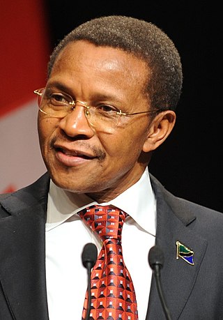
Jakaya Mrisho Kikwete is a Tanzanian politician who was the fourth president of Tanzania, in office from 2005 to 2015.

Sault Ste. Marie is a federal electoral district in Ontario, Canada, that has been represented in the House of Commons of Canada since 1968.

Thunder Bay—Superior North is a federal electoral district in Ontario, Canada, that has been represented in the House of Commons of Canada since 1976.

Songea is the capital of Ruvuma Region in southwestern Tanzania. It is located along the A19 road. The city has a population of 286,285, and is the seat of the Roman Catholic Archdiocese of Songea. Between 1905 and 1907, the city was a centre of African resistance during the Maji Maji Rebellion in German East Africa. The city is poised to experience significant economic growth in the near future as the Mtwara Corridor opens up in a few years. It is projected to be the sixth fastest growing city on the African continent between 2020 and 2025, with a 5.74% growth.

Mtwara is the capital city of Mtwara Region in southeastern Tanzania. In the 1940s, it was planned and constructed as the export facility for the disastrous Tanganyika groundnut scheme, but was somewhat neglected when the scheme was abandoned in 1951. The city is spread out over a large area planned to accommodate up to 200,000 people. The present population is around 141,000. As part of the development associated with the failed Tanganyika groundnut scheme, Mtwara features a deep-water port that can accommodate ocean-going vessels, and a range of large municipal buildings, including a post office. Recent improvements in the port made it possible for big container ships to berth there.
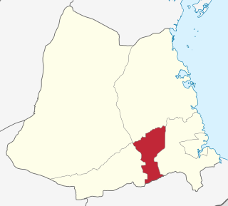
Ruangwa is one of six districts of the Lindi Region of Tanzania. It is bordered to the north by the Kilwa District, to the south by the Mtwara Region and to the west by the Nachingwea District.

Masasi is one of the six districts of the Mtwara Region of Tanzania. It is bordered to the north by the Lindi Region, to the east by the Newala District, to the south by the Ruvuma River and Mozambique and to the west by Nanyumbu District.

Newala is a district of the Mtwara Region of Tanzania. It is bordered to the west by Masasi District, to the east by Tandahimba District, to the south by Newala Town, and to the north by Tandahimba and Masasi Districts. The district includes the Miyuyu Forest Reserve.

Mtwara District is one of the five districts of the Mtwara Region of Tanzania. It is bordered to the south by Mozambique, to the west by the Tandahimba District, to the north by the Lindi Region and to the east by Mtwara-Mikindani District and the Indian Ocean.

Mtwara Airport is an airport in southern Tanzania serving the town of Mtwara.
Mtwara Thermal Power Station is a power plant owned by the Tanzania Electric Supply Company. The station has a capacity of 18 MW (24,000 hp) and uses natural gas from the Mnazi Bay gas wells in Mtwara. The station is not connected to the national grid but is instead connected to the Mtwara/Lindi mini-grid.

Ndanda Sports Club is a professional football club based in the city of Mtwara, Tanzania. They compete in the Championship, the second tier of league football in Tanzania.
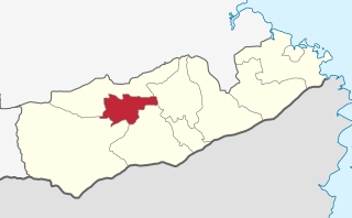
Masasi Town District Council is one of eight regional councils of the Mtwara Region in Tanzania. It is bordered to the north and south by the Masasi District, to the east by the Newala District and to the west by the Nanyumbu District. According to the 2012 census, the district has a total population of 102,969.

Mtwara Mikindani Municipal District Council is one of eight regional councils of the Mtwara Region in Tanzania. It is bordered to the north by the Lindi Region, to the east by the Indian Ocean and to the south and west by the Mtwara District. In 2016, the municipality has a total population of 113,732.
Jida is an administrative ward in Masasi Town Council of Mtwara Region in Tanzania. The ward covers an area of 90.4 km2 (34.9 sq mi), and has an average elevation of 403 m (1,322 ft). According to the 2012 census, the ward has a total population of 8,237.
Mkuti is an administrative ward in Masasi Town Council of Mtwara Region in Tanzania. The ward covers an area of 2.9 km2 (1.1 sq mi), and has an average elevation of 407 m (1,335 ft). According to the 2012 census, the ward has a total population of 7,807.

Nanyamba Town, is a district established in 2016 of the Mtwara Region in the southern coastal Tanzania. Nanyamba is in the eastern portion of the Mtwara Region, near the coast.

Newala Town, is a district level town council in the Mtwara Region in the southern coastal Tanzania. The town is in the south central portion of the Mtwara Region, on the northern bank of the Ruvuma River that is the border between Tanzania and Mozambique. The district was established on the 25th of September, 2015.
