

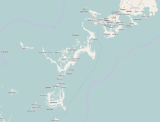
Ngarchelong is a state in Palau. Ngarchelong is at the northernmost tip of the island of Babeldaob. Only the state of Kayangel is farther north. Ngarchelong is an important historical site and has undergone archeological excavation.

Lake Päijänne is the second largest lake in Finland. The lake drains into the Gulf of Finland via the Kymi River. The major islands are from north to south Vuoritsalo, Muuratsalo, Onkisalo, Judinsalo, Edessalo, Taivassalo, Haukkasalo, Vehkasalo, Mustassalo, Virmailansaari and Salonsaari. The largest island is Virmailansaari. The word saari means an island. Salo once meant a great island, nowadays it means a great forest area.

The Battle of Angaur was a battle of the Pacific campaign in World War II, fought on the island of Angaur in the Palau Islands from 17 September—22 October 1944. This battle was part of a larger offensive campaign known as Operation Forager which ran from June 1944 to November 1944 in the Pacific Theater of Operations, and Operation Stalemate II in particular.

The Arafura Sea lies west of the Pacific Ocean, overlying the continental shelf between Australia and Indonesian New Guinea.
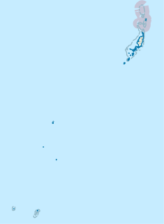
Kayangel is the northernmost state of Palau 24 km (15 mi) north of Koror. The land area is about 1.4 km2 (0.54 sq mi). The population is 54.
Caesium (55Cs) has 40 known isotopes, making it, along with barium and mercury, one of the elements with the most isotopes. The atomic masses of these isotopes range from 112 to 151. Only one isotope, 133Cs, is stable. The longest-lived radioisotopes are 135Cs with a half-life of 2.3 million years, 137Cs with a half-life of 30.1671 years and 134Cs with a half-life of 2.0652 years. All other isotopes have half-lives less than 2 weeks, most under an hour.

Grenadines is an administrative parish of Saint Vincent and the Grenadines, comprising the islands of the Grenadines other than those belonging to Grenada. The capital is Port Elizabeth.

Ngeremlengui is one of Palau's sixteen states. It has a population of 350, and is just west of the capital in Melekeok state. The capital of the state of Ngeremlengui is Imeong. Ngeremlengui is on the western side of Babeldaob, which is the largest island in Palau. Ngarelemgui is the largest of Palau's sixteen states in terms of land, and has an area of roughly 65 km2.

Sútor is a village and municipality in the Rimavská Sobota District of the Banská Bystrica Region of southern Slovakia.

Shawan County, also transliterated from Chinese to Uyghur as Savan County, is a county situated in the north of the Xinjiang Uyghur Autonomous Region and is under the administration of the Tacheng Prefecture. It has an area of 12,468 km2 (4,814 sq mi) with a population of 200,000. The Postcode is 832100.

Tuzsér is a village in Szabolcs-Szatmár-Bereg county, in the Northern Great Plain region of eastern Hungary.
Montreal Area Control Centre is one of 7 Area Control Centres in Canada operated by Nav Canada. Montreal ACC is located in a building on the outskirts of Montréal–Pierre Elliott Trudeau International Airport.

Takamatsu Castle is located in Takamatsu, Kagawa Prefecture, on the island of Shikoku, Japan. This castle is also called Tamamo Castle.

Kovioci is a village in the municipality of Brus, Serbia. According to the 2002 census, the village has a population of 156 people.

The borders of the oceans are the limits of Earth's oceanic waters. The definition and number of oceans can vary depending on the adopted criteria.
Tìa Dình is a commune (xã) and village of the Điện Biên Đông District of Điện Biên Province, northwestern Vietnam. The commune covers an area of 98.82 square kilometres and has a reported population of 2468.
Bablomekang is an island in the Rock Islands of Palau. It was last inhabited 2004, when inhabitants decided to move due to floodings.
Ngelsibel is an island of Palau.
German submarine U-133 was a Type VIIC U-boat built for Nazi Germany's Kriegsmarine for service during World War II. She was laid down on 10 August 1940 by Vegesacker Werft, Bremen-Vegesack as yard number 12, launched on 28 April 1941 and commissioned on 5 July that year. U-133 sank with all hands lost after striking a mine off Aegina island Greece on 14 March 1942. In 1986 the professional divers Efstáthios "Státhis" Baramátis and Theófilos Klímis located an unknown wreck at a depth of 74 meters that identified as a German submarine due to the compass of the vessel. Almost ten years later, in the mid-90s, the same wreck was further identified by Greek divers as the U-133.
Coordinates: 7°08′N134°21′E / 7.133°N 134.350°E
| | This Palau location article is a stub. You can help Wikipedia by expanding it. |