
Hume Lake is a reservoir in the Sierra Nevada, within Sequoia National Forest and Fresno County, central California.

Lake Oroville is a reservoir formed by the Oroville Dam impounding the Feather River, located in Butte County, northern California. The lake is situated 5 miles (8 km) northeast of the city of Oroville, within the Lake Oroville State Recreation Area, in the western foothills of the Sierra Nevada. Known as the second-largest reservoir in California, Lake Oroville is treated as a keystone facility within the California State Water Project by storing water, providing flood control, recreation, freshwater releases to assist in controlling the salinity intrusion into the Sacramento-San Joaquin Delta and protecting fish and wildlife.

Table Rock Lake is an artificial lake or reservoir in the Ozarks of southwestern Missouri and northwestern Arkansas in the United States. Designed, built and operated by the U.S. Army Corps of Engineers, the lake is impounded by Table Rock Dam, which was constructed from 1954 to 1958 on the White River.

Tuttle Creek Lake is a reservoir on the Big Blue River 5 miles (8 km) north of Manhattan, in the Flint Hills region of northeast Kansas. It was built and is operated by the Army Corps of Engineers for the primary purpose of flood control. Secondary functions of the project include release of water stores to maintain barge traffic on the Mississippi River during seasons of drought, maintenance of a multi-use conservation pool for fish and wildlife enhancement and recreation, and release of sufficient water in droughts to maintain water quality for downstream communities.

Lake Hartwell is a man-made reservoir bordering Georgia and South Carolina and encompassing parts of the Savannah, Tugaloo, and Seneca rivers. Lake Hartwell is one of the Southeastern United States' largest recreation lakes. The lake was created by the construction of the Hartwell Dam, completed in 1962 and located on the Savannah River seven miles (11 km) below the point at which the Tugaloo and Seneca Rivers join to form the Savannah. Extending 49 miles (79 km) up the Tugaloo and 45 miles (72 km) up the Seneca at normal pool elevation, the lake comprises nearly 56,000 acres (230 km2) of water with a shoreline of 962 miles (1,548 km). The entire Hartwell "Project" contains 76,450 acres (309 km2) of land and water. I-85 bisects Hartwell Lake and makes the area easily accessible to visitors.

Isabella Dam is an embankment dam located in the Kern River Valley, about halfway down the Kern River course, between the towns of Kernville and Lake Isabella in Kern County, California.

Kettle Creek State Park is a 1,793-acre (726 ha) Pennsylvania state park in Leidy Township, Clinton County, Pennsylvania in the United States. The park is in a valley and is surrounded by mountains and wilderness. It features the Alvin R. Bush Dam built in 1961 by the U.S. Army Corps of Engineers as a flood control measure in the West Branch Susquehanna River basin. Many of the recreational facilities at the park were built during the Great Depression by the young men of the Civilian Conservation Corps. Kettle Creek State Park is seven miles (10 km) north of Westport and Pennsylvania Route 120. It is largely surrounded by Sproul State Forest.
Clarence F. Walker Lake is a 239-acre (0.97 km²) reservoir, formed by a dam and used for flood control and recreation. It is located in Adams Township, Snyder County, Pennsylvania near the town of Troxelville. The lake and shoreline are owned and managed by the Pennsylvania Fish and Boat Commission (PFBC) for recreational fishing and boating. Fish species present include northern pike, largemouth bass, walleye, black crappie, and bluegill.

Mountain Park Dam is located just upstream of Snyder Dam, on Otter Creek near Mountain Park, Oklahoma. Snyder Lake was drained to accommodate construction of Mountain Park Dam, then restored upon completion of construction, which was performed by O'Neal Construction, Inc. of Ann Arbor, MI. The lake is maintained at sufficient elevation to provide a plunge pool for water released or spilled from the dam. Mountain Park dam impounds the waters of Tom Steed Reservoir.

Alum Creek Lake is a man-made reservoir located in Delaware County, Ohio, United States. It was built in 1974, covers 5 square miles (13 km2), and has a maximum capacity of 134,815 acre-feet (166,292,000 m3).
The Jamestown Dam is a rolled-earth dam spanning the James River in Stutsman County in the U.S. state of North Dakota, serving the primary purpose of flood control. It is north of the city of Jamestown, North Dakota. Built from April 1952 to September 1953, the dam measures 1,418 feet (432 m) long at the crest and 85 feet (26 m) high. It impounds the James River to form the Jamestown Reservoir. A small islet lies shortly upstream of the dam, where the James River previously split into two channels.

John Redmond Reservoir is a reservoir on the Neosho River in eastern Kansas. Built and managed by the U.S. Army Corps of Engineers, it is used for flood control, recreation, water supply, and wildlife management. It borders the Flint Hills National Wildlife Refuge to the northwest.

Santa Fe Dam is a flood-control dam on the San Gabriel River located in Irwindale in Los Angeles County, California, United States. For most of the year, the 92-foot (28 m)-high dam and its reservoir lie empty, but can hold more than 45,000 acre-feet (56,000,000 m3) of water during major storms. During the dry season, the basin behind the dam is used for groundwater recharge, as well as various recreational activities.

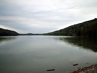
Leesville Lake is a reservoir located near Ohio State Route 212 and Leesville, Ohio. The lake is formed by Leesville Dam 40°28′6″N81°11′41″W across McGuire Creek, a tributary of Conotton Creek. The lake is named for the village of Leesville.

Canonsburg Lake is a lake in Canonsburg, Pennsylvania. It is an artificial lake formed by the waters of Little Chartiers Creek behind a 525 feet (160 m) long and 45 feet (14 m) high concrete dam. The dam was built in 1943 by Alcoa to create a freshwater reservoir for the Canonsburg Forging Plant, which was considered a strategic resource during World War II. In 1957, the Pennsylvania Fish and Boat Commission (PFBC) acquired the 138-acre property from Alcoa, which included the 76-acre surface area of the lake plus the dam and surrounding lands. The PFBC converted the body of water from an industrial reservoir into a recreational lake.

Sulphur Creek Dam is a dam across Sulphur Creek in Orange County, California. The dam creates Laguna Niguel Lake and is entirely within the city of Laguna Niguel. The reservoir is used for water reclamation storage and recreation, and is the main attraction of Laguna Niguel Regional Park, which surrounds it.
Lake Hudson, also known as Markham Ferry Reservoir, is a man-made reservoir in Mayes County, Oklahoma, United States, about 2 miles (3.2 km) northwest of Locust Grove, Oklahoma and 8 miles (13 km) southeast of Pryor, Oklahoma. It was created by the completion of the Robert S. Kerr Dam on the Grand River in 1964. It is managed by the Grand River Dam Authority (GRDA).
The Briar Creek Reservoir is a reservoir in Columbia County, Pennsylvania, in the United States. It has an area of 51.04 acres and is located in Briar Creek Township. The lake is situated on East Branch Briar Creek. The lake was constructed in the early 1970s for the purpose of flood control. It is dammed by the Briar Creek Dam. Shale and limestone rocks are found in the lake's vicinity. The lake was electrofished by the Pennsylvania Fish and Boat Commission in 2010. The reservoir is designated as Approved Trout Waters and is stocked with trout. More than a dozen species of fish inhabit it and several bird species are found in its vicinity. The lake is part of the 173-acre Briar Creek Lake Park. Fishing and boating are done in the reservoir.

Leaser Lake is a man-made lake located near the village of Jacksonville in Lynn Township, Lehigh County, Pennsylvania. The lake is owned by the Commonwealth and managed by the Pennsylvania Fish and Boat Commission (PFBC).
Lake Tyler East is a reservoir on Mud Creek in the Neches River Basin of Smith County, Texas. It is neighbored by Whitehouse, Texas that is encompassed by Tyler, Texas which resides within the South Central Plains ecoregion.


