
Bidean nam Bian is the highest peak in a group of mountains south of Glen Coe and north of Glen Etive in the Scottish Highlands. With a height of 1,150 metres (3,770 ft), it is a Munro and the highest point in Argyll. It is a complex mountain, with many ridges and subsidiary peaks, one of which, Stob Coire Sgreamhach, is classified as a separate Munro.

Stob Coire Sgreamhach is a mountain in Lorn, south of Glen Coe in the Scottish Highlands. Its height is 1,072 metres (3,517 ft). It is part of the Bidean nam Bian massif and is often considered a subsidiary peak of Bidean, though since the 1997 revision of Munros Tables it has been classified as a separate Munro. To the northeast is the ridge of Beinn Fhada.
Meall Buidhe is a Munro situated in the southern highlands of Scotland. It forms the northern side of Loch an Daimh and is often climbed in conjunction with Stuchd an Lochain. The normal route climbs north from the eastern end of the loch until easier ground is reached. The route angles east and then north once the ridge is gained. Strong walkers can continue round the loch and take in a Corbett, Sron a' Choire Chnapanich, and the aforementioned Stuchd an Lochain.

Meall a' Bhùiridh (IPA:[ˈmauɫ̪ˈaˈvuːɾʲɪʝ]) is a mountain on the edge of Rannoch Moor in the Highlands of Scotland. It lies near the top of Glen Coe and Glen Etive, overlooking the Kings House Hotel inn and the A82 road. The Glencoe Ski area is located on the northern slopes of the peak.
Beinn Dearg is a mountain in the Inverlael area of the Highlands of Scotland. It is most frequently climbed by following the River Lael up Gleann na Sguaib. Starting from near the head of Loch Broom, a path follows the glen to a bealach, which is about 1 kilometre (0.62 mi) north of the summit. From this bealach, the neighbouring peaks of Cona' Mheall and Meall na Ceapraichean may also be climbed. Eididh nan Clach Geala, which lies about 3 kilometres (1.9 mi) north of Beinn Dearg, is also added in to complete a round of four Munros.
Meall Garbh is a mountain in the southern part of the Scottish Highlands. With Meall Greigh it forms the north-eastern end of the Ben Lawers range. Its craggy south face overlooks Lochan nan Cat.
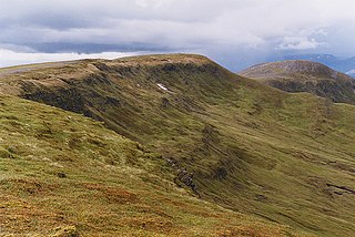
Meall Garbh is a mountain on the north side of Glen Lyon in the Scottish Highlands. The flat summit of the hill has two tops of almost equal height, the north-west one being considered the higher.

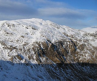
Creise is a mountain summit in the Black Mount range, in the Scottish Highlands. It overlooks the northern end of Glen Etive and its height is 1,100 metres (3,600 ft). Creise is one of four Munros in the Black Mount, along with Meall a' Bhuiridh, Stob Ghabhar and Stob a' Choire Odhair. The mountain is a long and flattish ridge, whose highest point was unnamed until 1981. It is popular with cross-country skiers, being near the White Corries ski area from where it is often climbed along with adjoining Meall a' Bhuiridh. The steep and craggy northern buttress, Sròn na Crèise, is well seen from the A82 road road and the Kings House Hotel.
Creag Mhòr is a mountain in the Breadalbane region of the Scottish Highlands. It is in the Forest of Mamlorn, ten kilometres northeast of Tyndrum, and is one of the remotest of the southern Highlands Creag Mhòr reaches a height of 1047 metres (3435 ft) and qualifies as a Munro and a Marilyn. It is often climbed with the neighbouring Munro of Beinn Heasgarnich; the two mountains form the high ground between Glen Lochay and Loch Lyon.

Meall Glas is a mountain situated in the southern highlands of Scotland. It stands on the northern border of the Loch Lomond and the Trossachs National Park, 8.5 kilometres north east of Crianlarich.

Beinn Sgulaird or Beinn Sguiliaird is a mountain in the Lorn region of the Scottish Highlands, between Glen Creran and Glen Etive. It has a height of 937 m (3074 ft) and is classed as a Munro. The mountain takes the form of a long ridge which runs from southwest to northeast, three kilometres of which lie above 800 m. Hillwalkers commonly traverse the ridge from north to south, as this gives the best views of the Hebrides to the west, in particular the Isle of Mull. While most walkers start from Glen Creran to the west, an ascent from Glen Etive is also possible.

Càrn Mairg is a mountain in the Breadalbane region of the Scottish Highlands, with a height of 1,042 metres (3,419 ft). It stands in a group of four Munro mountains known as the 'Càrn Mairg group', on the north side of Glen Lyon, Perthshire.

Càrn Gorm is a mountain in the Breadalbane region of the Scottish Highlands, with a height of 1,029 metres (3,376 ft). It stands in a group of four Munro mountains known as the Càrn Mairg group or the Glen Lyon Horseshoe, on the north side of Glen Lyon, Perthshire.

Chno Dearg is a mountain in the Lochaber area of the Scottish Highlands. It overlooks Glen Spean to the north and Loch Treig to the west. With a height of 1,046 metres (3,432 ft), it is classed as a Munro.

Meall nan Tarmachan is a mountain in the Southern Highlands of Scotland near Killin just west of Ben Lawers. It is often climbed as part of the Tarmachan ridge, the other peaks of which are Meall Garbh, Beinn nan Eachan and Creag na Caillich ; these three peaks are Tops rather than Munros, and lie to the south-west of Meall nan Tarmachan.

Meall Ghaordaidh is a mountain in the Southern Highlands of Scotland, approximately 10 km north-west of Killin.

Sgùrr Thuilm is a mountain in the Glenfinnan area of the Highlands of Scotland. It stands at the head of Glen Finnan approximately 7 kilometres (4 mi) north of Loch Shiel.

Sgùrr na h-Ulaidh is a mountain lying to the south of the village of Glencoe in the Scottish Highlands. The mountain cannot be seen from the main A82 road as it is hidden behind Aonach Dubh a'Ghlinne.

Beinn nan Aighenan is a 960-metre (3,150 ft) high mountain in the Grampian Mountains of Scotland. It lies in Argyll and Bute, north of the village of Taynuilt.
