Related Research Articles

Medford is a city 6.7 miles (10.8 km) northwest of downtown Boston on the Mystic River in Middlesex County, Massachusetts, United States. At the time of the 2020 U.S. Census, Medford's population was 59,659. It is home to Tufts University, which has its campus along the Medford and Somerville border.

Somerville is a city located directly to the northwest of Boston, and north of Cambridge, in Middlesex County, Massachusetts, United States. As of the 2020 United States Census, the city had a total population of 81,045 people. With an area of 4.12 square miles (10.7 km2), the city has a density of 19,671/sq mi (7,595/km2), making it the most densely populated municipality in New England and the 16th most densely populated incorporated municipality in the country. Somerville was established as a town in 1842, when it was separated from Charlestown. In 2006, the city was named the best-run city in Massachusetts by The Boston Globe. In 1972, 2009, and 2015, the city received the All-America City Award. It is home to Tufts University, which has its campus along the Somerville and Medford border.

Stoneham is a town in Middlesex County, Massachusetts, nine miles (14.5 km) north of downtown Boston. Its population was 23,244 at the 2020 census. Its proximity to major highways and public transportation offer convenient access to Boston and the North Shore coastal region and beaches of Massachusetts. The town is the birthplace of the Olympic figure-skating medalist Nancy Kerrigan and is the location of the Stone Zoo.

Ball Square is a neighborhood primarily in Somerville, Massachusetts, but also extending into Medford, at the intersection of Boston Avenue and Broadway, located between Powder House Square and Magoun Square. It is primarily a residential area with a handful of shops and restaurants along Broadway. Located on the edge of the neighborhood surrounding Tufts University, Ball Square contains a mix of businesses serving the student and academic populations as well as those reflecting the more blue-collar neighborhoods to the east. These establishments include Kelly's Diner, Sound Bites, and Ball Square Cafe, all popular for breakfast; True Grounds, a coffee shop; Taco Party, Lyndell's Bakery; House of Kebab, an Indian restaurant; and Avenue Kitchen and Bar.

Magoun Square is a neighborhood centered on the intersection of Broadway and Medford Streets on the border of Medford and Somerville, Massachusetts. It is located between the neighborhoods of Ball Square and Winter Hill. It is a mixed-use urban business district, with commercial sites in the square and residential areas surrounding it. Trum Field, a park featuring baseball diamonds and basketball courts, is near Magoun Square, as are the headquarters of the Somerville Department of Public Works. Notable residents include playwright John Shea.

Teele Square is at the intersection of Broadway, Holland Street, and Curtis Street in Somerville, Massachusetts, a half-mile from Davis Square and the Davis Square stop on the MBTA Red Line, as well as a half-mile from Alewife Brook Parkway and Powder House Square. The square sits on Clarendon Hill, one of the seven hills of Somerville. The square is named after Jonathan W. Teele, who resided in an early portion of Charlestown that eventually became Somerville in 1842.

Interstate 695 was a planned six-lane auxiliary Interstate Highway in Boston, Massachusetts, that would have run through parts of Boston, Brookline, Cambridge, and Somerville.

Charlestown High School is a public school located at 240 Medford Street in Charlestown, Boston, Massachusetts, United States. Charlestown High School is the only high school in Charlestown. Charlestown is part of the Boston Public Schools. According to the article, "Focus On Children, the Boston Publics Schools School Report Card," of the students enrolled in 2003-2004, 70.6% were in regular education 7.1% in bilingual education, and 22.2% in the special education. The racial/ethnic composition of the student population in the school was: 46.3% Black, 26.4% Hispanic, 19.5% Asian, and 7.6% White.

The Fitchburg Railroad is a former railroad company, which built a railroad line across northern Massachusetts, United States, leading to and through the Hoosac Tunnel. The Fitchburg was leased to the Boston and Maine Railroad in 1900. The main line from Boston to Fitchburg is now operated as the MBTA Fitchburg Line; Pan Am Railways runs freight service on some other portions.
Winter Hill is a neighborhood in Somerville, Massachusetts. It gets its name from the 120-foot hill that occupies its landscape, the name of which dates back to the 18th century. Winter Hill is located roughly north of Medford Street, west of McGrath Highway, and east of Magoun Square.

Route 28 is a 151.93-mile-long (244.51 km) nominally south–north state highway in the U.S. state of Massachusetts, running from the town of Eastham via Boston to the New Hampshire state line in Methuen. Following the route from its nominally southern end, Route 28 initially heads south to the town of Chatham then turns west to follow along the south shore of Cape Cod. In Falmouth, Route 28 turns north and continues through the western part of Plymouth County and the eastern part of Norfolk County; it then passes through downtown Boston before heading north via Lawrence to the New Hampshire state line, where it continues as New Hampshire Route 28.
East Cambridge is a neighborhood of Cambridge, Massachusetts. Referred to in modern times as Area 1, East Cambridge is bounded by the Charles River and the Charlestown neighborhood of Boston on the east, the Somerville border on the north, Broadway and Main Street on the south, and the railroad tracks on the west. Most of the streets form a grid aligned with Cambridge Street, which was laid out to directly connect what is now the Charles River Dam Bridge with what in 1809 was the heart of Cambridge, Harvard Square. The northern part of the grid is a roughly six by eight block residential area. Cambridge Street itself is retail commercial, along with Monsignor O'Brien Highway, the Twin Cities Plaza strip mall, and the enclosed Cambridgeside Galleria. Lechmere Square is the transportation hub for the northern side. The southern half of the grid is largely office and laboratory space for hundreds of dot-com companies, research labs and startups associated with MIT, biotechnology firms including Genzyme, Biogen and Moderna, the Athenaeum Press Building, light industry, an NRG Energy power station, and various small businesses. This half of the neighborhood is generally identified with Kendall Square. Along the waterfront are several hotels and taller apartment buildings.

Massachusetts's 7th congressional district is a congressional district located in eastern Massachusetts, including roughly three-fourths of the city of Boston and a few of its northern and southern suburbs. The seat is currently held by Democrat Ayanna Pressley.

South Medford is the southern neighborhood of Medford, Massachusetts.
Cambridge Health Alliance (CHA) is a healthcare provider in Cambridge, Somerville and Boston's metro-north communities in Massachusetts. CHA offers services including primary care, specialty care, and mental health/substance use services. It includes two acute care hospitals, primary care and specialty practice facilities, and the Cambridge Public Health Department. CHA maintains an affiliation with Beth Israel Deaconess Medical Center in Boston and is a Tufts University School of Medicine and Harvard Medical School teaching affiliate.

Ten Hills is a neighborhood in the northeastern part of the city of Somerville, Massachusetts. The area is roughly wedge-shaped, about 50 acres (200,000 m2) in size, and is bounded by the Mystic River to the north, McGrath Highway to the east, and is largely separated from the rest of Somerville by Interstate 93 to the southwest. Ten Hills is next to Assembly Square in the east, and Winter Hill in the southwest. The neighborhood landscape is predominated by a single hill, the peak of which is roughly at the intersection of Temple and Putnam Roads. The Ten Hills neighborhood is located in Ward 4, Precinct 1 of the City of Somerville, which is in the 34th district of Middlesex County.
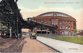
Sullivan Square is a traffic circle located at the north end of the Charlestown neighborhood of Boston, Massachusetts. It is named after James Sullivan, an early 19th-century Governor of Massachusetts. Sullivan Square station on the MBTA Orange Line is located just west of the square.

East Somerville is a neighborhood in the eastern part of the city of Somerville, Massachusetts. The community stretches east along Broadway from Massachusetts Route 28 to Sullivan Square and Interstate 93 on the city line with the Boston neighborhood of Charlestown.

The Amelia Earhart Dam is an earth-fill dam spanning the Mystic River near its mouth between Somerville and Everett, Massachusetts. It was built in 1966 to regulate tidal effects and the incursion of salt water in the upstream river basin. It has 3 locks for marine traffic. The largest is 325 feet long, and 45 feet wide; the two smaller locks are 120 feet long and, 22 feet wide. There is no public access to the dam.

Gilman Square is a neighborhood in the area around Central Hill in Somerville, Massachusetts. Historic Gilman Square is at the junction of Medford, Pearl, and Marshall streets and has been a small commercial center since the mid 19th-century but with the development of the Gilman Square Green Line station, city planning documents consider the area within a rough ten-minute walk of the new station to be part of the Gilman Square neighborhood.
References
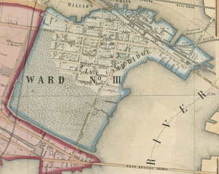
- ↑ Somerville, Past and Present by Edward Augustus Samuels, Henry Hastings Kimball, 1897. p. 78.
| | This Massachusetts road-related article is a stub. You can help Wikipedia by expanding it. |
Coordinates: 42°24′19.3″N71°6′4.5″W / 42.405361°N 71.101250°W