Road transport or road transportation is a type of transport using roads. Transport on roads can be roughly grouped into the transportation of goods and transportation of people. In many countries licensing requirements and safety regulations ensure a separation of the two industries. Movement along roads may be by bike, automobile, bus, truck, or by animal such as horse or oxen. Standard networks of roads were adopted by Romans, Persians, Aztec, and other early empires, and may be regarded as a feature of empires. Cargo may be transported by trucking companies, while passengers may be transported via mass transit. Commonly defined features of modern roads include defined lanes and signage. Various classes of road exist, from two-lane local roads with at-grade intersections to controlled-access highways with all cross traffic grade-separated.

A toll road, also known as a turnpike or tollway, is a public or private road for which a fee is assessed for passage. It is a form of road pricing typically implemented to help recoup the costs of road construction and maintenance.

The Massachusetts Turnpike is a toll highway in the US state of Massachusetts that is maintained by the Massachusetts Department of Transportation (MassDOT). The turnpike begins at the New York state line in West Stockbridge, linking with the Berkshire Connector portion of the New York State Thruway. Spanning 138 miles (222 km) along an east–west axis, the turnpike constitutes the Massachusetts section of Interstate 90 (I-90). The turnpike is the longest Interstate Highway in Massachusetts, while I-90, in full, is the longest Interstate Highway in the United States.
E-ZPass is an electronic toll collection system used on toll roads, toll bridges, and toll tunnels in the Eastern United States, Midwestern United States, and Southern United States. The E-ZPass Interagency Group (IAG) consists of member agencies in several states, which use the same technology and allow travelers to use the same transponder on toll roads throughout the network.

State Road 528 (SR 528), alternatively named the Martin Andersen Beachline Expressway, is a partially-tolled state road in the U.S. state of Florida; it is maintained by the Florida's Turnpike Enterprise (FTE), the Central Florida Expressway Authority (CFX), and the Florida Department of Transportation (FDOT). Spanning approximately 53 miles (85 km) along a west–east axis, it connects Interstate 4 (I-4) in Orlando with I-95, Titusville, and Cape Canaveral on the Space Coast. It passes close to the tourist areas of Orlando, including SeaWorld and Universal Orlando, and serves the north entrance to Orlando International Airport. Near its east end, it passes over the Intracoastal Waterway on the Emory L. Bennett Causeway, and ends at SR A1A and SR 401 near Port Canaveral.
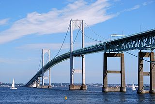
The Claiborne Pell Bridge, commonly known as the Newport Bridge, is a suspension bridge operated by the Rhode Island Turnpike and Bridge Authority that spans the East Passage of the Narragansett Bay in Rhode Island. The bridge, part of RI 138, connects the city of Newport on Aquidneck Island and the Town of Jamestown on Conanicut Island, and is named for longtime Rhode Island U.S. senator Claiborne Pell who lived in Newport. The Pell Bridge is in turn connected to the mainland by the Jamestown Verrazzano Bridge.

Route 28 is a 151.93-mile-long (244.51 km) nominally south–north state highway in the U.S. state of Massachusetts, running from the town of Eastham via Boston to the New Hampshire state line in Methuen. Following the route from its nominally southern end, Route 28 initially heads south to the town of Chatham then turns west to follow along the south shore of Cape Cod. In Falmouth, Route 28 turns north and continues through the western part of Plymouth County and the eastern part of Norfolk County; it then passes through downtown Boston before heading north via Lawrence to the New Hampshire state line, where it continues as New Hampshire Route 28.

Transportation in Richmond, Virginia and its immediate surroundings include land, sea and air modes. This article includes the independent city and portions of the contiguous counties of Henrico and Chesterfield. While almost all of Henrico County would be considered part of the Richmond area, southern and eastern portions of Chesterfield adjoin the three smaller independent cities of Petersburg, Hopewell, and Colonial Heights, collectively commonly called the Tri-Cities area. A largely rural section of southwestern Chesterfield may be considered not a portion of either suburban area.

Interstate 95 (I-95) is an Interstate Highway on the east coast of the United States, connecting Florida to Maine. Within the state of New Hampshire, it serves the Seacoast Region and is a toll road named the Blue Star Turnpike or New Hampshire Turnpike. The 16-mile (26 km) turnpike is maintained by the New Hampshire Department of Transportation (NHDOT) Bureau of Turnpikes and has a single toll plaza near Hampton.
Toll roads in Great Britain, used to raise fees for the management of roads in the United Kingdom, were common in the era of the turnpike trusts. Currently there is a single major road, the M6 Toll and a small number of bridges and tunnels where tolls are collected. In addition, there are also two UK road pricing schemes, the London congestion charge and the Durham congestion charge.

The Cambridge and Concord Turnpike was an early turnpike between Cambridge and Concord, Massachusetts. Portions have been incorporated into today's Massachusetts Route 2; the remainder forms other major local roads.
The Middlesex Turnpike was an early turnpike between Cambridge and Tyngsborough, Massachusetts and the New Hampshire border, where it connected with the Amherst Turnpike and thence Nashua and Claremont, New Hampshire.
The Snicker's Gap Turnpike was a turnpike road in the northern part of the U.S. state of Virginia. Part of it is now maintained as State Route 7, a primary state highway, but the road between Aldie and Bluemont in Loudoun County, via Mountville, Philomont, and Airmont, is a rural Virginia Byway known as Snickersville Turnpike, and includes the about 180-year-old Hibbs Bridge over Beaverdam Creek. This turnpike replaced, in part, the first toll road in the United States, which consisted of two roads from Alexandria northwest into the Shenandoah Valley.
There are approximately 25 current toll roads in the state of Texas. Toll roads are more common in Texas than in many other U.S. states, since the relatively low revenues from the state's gasoline tax limits highway planners' means to fund the construction and operation of highways.
The Port Kent and Hopkinton Turnpike was a 19th-century toll road in the North Country of New York in the United States. It began in the town of Hopkinton and ended at the hamlet of Port Kent, located on the western shore of Lake Champlain. The turnpike was constructed in the early 1830s and was completed in 1833. The tolls along the road were removed just five years later; however, parts of the former turnpike later became the basis for several 20th century state highways. One, the former New York State Route 99 (NY 99), is still known today as the "Port Kent–Hopkinton Turnpike".
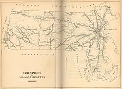
The Fifth Massachusetts Turnpike was one of over 60 toll roads in operation throughout Massachusetts in the first half of the 19th century. An act establishing the Corporation was approved by the Massachusetts legislature on March 1, 1799. The Preamble to the act reads:
The Barre Turnpike was one of over 60 toll roads in operation throughout Massachusetts in the first half of the 19th century. As described in the Act of Incorporation, February 5, 1822, the road ran
from the Common, near the meeting house in Barre; thence easterly, in the best course to Hubbardston line thence through the southerly part of Hubbardston, in the best direction to Princeton line; thence, in the best course, through part of Princeton, and through the land of David Rice; and thence through land of Jason Woodward, to a road crossing a town road, and to a road leading to Edward Goodenow's.
The Seneca Road Company was formed to improve the main road running west from Utica, New York, the Genesee Road, from Utica to Canandaigua and operate it as a toll road or turnpike. The road was originally laid out in 1794 from Baggs Square in downtown Utica at the ford of the Mohawk River and followed the Indian trail past Syracuse to Canandaigua. Some accounts say it went to Geneva and Avon originally. There was no City of Syracuse then. The road became known as the Seneca Turnpike, which was 157 miles (253 km) long and, at the time, the longest toll road in the state.

The Union Turnpike was one of over 60 toll roads in operation throughout Massachusetts in the first half of the 19th century. In the early part of 1803, a group of investors headed by Henry Bromfield (1727-1820) petitioned the Massachusetts State Legislature to form a corporation for the purpose of constructing a toll road from the center of Concord to Leominster.