Central Turnpike (Massachusetts)

Last updated
Map of the 19th century turnpikes
in Massachusetts 19th century turnpikes Massachusetts.jpg
Map of the 19th century turnpikes
in Massachusetts

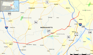
The Central Turnpike was a private toll road in Massachusetts that was chartered by the Massachusetts State Legislature on June 12, 1824. [1] The route began in Wellesley (at the time known as West Needham), heading west to Dudley, where it continued into Connecticut as the Center Turnpike.

19th-century turnpikes in Massachusetts highway system

In the late 18th century and early 19th century, turnpikes, as opposed to ordinary roads of the same time, were roads where gates barred travelers from continuing and at which payments were demanded for the use of the road. The word "turnpike" itself comes from the fact that these gates, called "pikes," were "turned" once the toll was paid. The privilege of building and operating turnpikes was conferred by the state legislature to "turnpike corporations". Turnpikes were constructed using private capital, were privately owned, and were operated for revenue from toll collection. The turnpike era in Massachusetts began in 1796, when the first act of incorporation for a turnpike was passed. By 1850, most turnpike corporations had either been dissolved or had stopped collecting tolls. In all, 118 acts of incorporation were passed. Typical toll rates were twenty-five cents for every coach with additional charges of four cents for every man and horse.

Massachusetts State of the United States of America

Massachusetts, officially the Commonwealth of Massachusetts, is the most populous state in the New England region of the northeastern United States. It borders on the Atlantic Ocean to the east, the states of Connecticut and Rhode Island to the south, New Hampshire and Vermont to the north, and New York to the west. The state is named after the Massachusett tribe, which once inhabited the east side of the area, and is one of the original thirteen states. The capital of Massachusetts is Boston, which is also the most populous city in New England. Over 80% of Massachusetts's population lives in the Greater Boston metropolitan area, a region influential upon American history, academia, and industry. Originally dependent on agriculture, fishing and trade, Massachusetts was transformed into a manufacturing center during the Industrial Revolution. During the 20th century, Massachusetts's economy shifted from manufacturing to services. Modern Massachusetts is a global leader in biotechnology, engineering, higher education, finance, and maritime trade.

Wellesley, Massachusetts Town in Massachusetts, United States

Wellesley is a town in Norfolk County, Massachusetts, United States. Wellesley is part of Greater Boston. The population was 27,982 at the time of the 2010 census. In 2008, Wellesley had the 3rd highest median household and family incomes in all of Massachusetts. In 2018, data from the American Community Survey revealed that Wellesley was the 7th wealthiest city in the United States. It is best known as the home of Wellesley College, Babson College, and a campus of Massachusetts Bay Community College.

The corporation was headed by Samuel Slater, Joseph Valentine, and John J. Clark. It was not completed until 1830, and was in revenue service for less than six years as a whole. In January 1836, the corporation ceded the entirety of its length in Middlesex County to the state, and made the remainder toll-free by 1839 when the corporation dissolved. The Connecticut portion of the turnpike, run as a separate corporation chartered in Connecticut, continued in service until 1853. [2]

Samuel Slater English-American industrialist

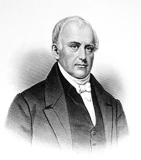
Samuel Slater was an early English-American industrialist known as the "Father of the American Industrial Revolution" and the "Father of the American Factory System". In the UK, he was called "Slater the Traitor" because he brought British textile technology to America, modifying it for United States use. He memorized the designs of textile factory machinery as an apprentice to a pioneer in the British industry before migrating to the United States at the age of 21. He designed the first textile mills in the US and later went into business for himself, developing a family business with his sons. A wealthy man, he eventually owned thirteen spinning mills and had developed tenant farms and company towns around his textile mills, such as Slatersville, Rhode Island.

Middlesex County, Massachusetts County in the United States

Middlesex County is a county in the Commonwealth of Massachusetts, in the United States. As of 2016, the estimated population was 1,589,774, making it the twenty-first most populous county in the United States, and the most populous county in both Massachusetts and New England. As part of the 2010 national census, the Commonwealth's mean center of population for that year was geo-centered in Middlesex County, in the town of Natick at. Middlesex County is included in the Census Bureau’s Boston–Cambridge–Newton, MA–NH Metropolitan Statistical Area.

Today, the route is still mostly in use as various public roads, only a short unimproved section between Northbridge and Upton is not in use today.

Northbridge, Massachusetts Town in Massachusetts, United States

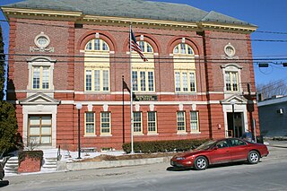
Northbridge is a town in Worcester County, Massachusetts, United States. The population was 15,707 at the 2010 census. The Northbridge Town Hall is located at 7 Main Street in Whitinsville. The town is now a part of the Blackstone River Valley National Heritage Corridor, of the National Park Service. Northbridge claims to history include: Native American Nipmuc lands, Colonel John Spring, who led the Uxbridge militia training company in the American Revolution, Samuel Spring, Revolutionary War Chaplain, the Residence of Ezra T. Benson 1830-1832, the birthplace of President Millard Fillmore's mother, Phoebe, and home to the Whitin Machine Works from 1831 to 1964

Upton, Massachusetts Town in Massachusetts, United States

Upton is a town in Worcester County, Massachusetts, United States. It was first settled in 1728. The population was 7,542 at the 2010 census, with over 2,100 households.

Route today

The Central Turnpike route begins in Wellesley, as the modern-day Central Street (Route 135) westbound, from its intersection with Grove Street and Washington Street (modern Route 16). This is how the historical route connected with the Worcester Turnpike (modern Route 9) as its charter stated. It follows Route 135 through Natick, Framingham, Ashland, and Hopkinton. In Hopkinton, it leaves the Route 135 alignment, and continues as West Main Street to the Upton town line. In Upton, it continues as Hopkinton Road, High Street, Hartford Avenue north, is briefly concurrent with Main Street (Route 140) across a multi-road intersection, to Hartford Ave south. The modern alignment then ends where the modern Clubhouse Lane continues, and an unimproved section of the original road continues to the Northbridge town line.

Massachusetts Route 135 highway in Massachusetts

Route 135 is a state highway in eastern Massachusetts, running from U.S. Route 20 in Northborough east to Interstate 95 in Dedham. The first 13 miles (21 km) of the Boston Marathon, from Hopkinton to Wellesley, follow Route 135.

Massachusetts Route 16 highway in Massachusetts

Route 16 is an east–west state highway in Massachusetts. It begins in the west at an intersection with Route 12 and Route 193 in Webster, just north of the Connecticut state border. It runs in a generally southwest-northeast routing through a number of Boston's suburbs and runs to the west and then north of the city before ending in Revere at an intersection with Route 1A and Route 60.

Massachusetts Route 9 highway in Massachusetts

Route 9 is a major east–west state highway in Massachusetts. Along with U.S. Route 20, Route 2, and Interstate 90, Route 9 is one of the major east–west routes of Massachusetts, and like the others its eastern terminus is in Boston. Starting at Copley Square and passing along Huntington Avenue, Route 9 is a limited access route through the MetroWest suburbs to Worcester, and is also a major alternative to the Pike's toll road west of the city. After passing along major city streets in that city, the road becomes a country route, passing through the central Worcester Hills, the Pioneer Valley, and the city of Northampton, and into The Berkshires. The road ends near the center of the city of Pittsfield.

Continuing in Northbridge as the unimproved road, it returns to public roads as Upton St. Crossing Route 122, it becomes Sutton Street. Through Sutton it is named Central Turnpike for its entire length. In Oxford, it is modern Sutton Avenue briefly, past the intersection with Douglas Road (historical Douglas Pike), to Joe Jenny Road until the Webster border. In Webster, it is Sutton Avenue until it reaches Gore Road (modern Route 16). It is concurrent with Route 16 west until its terminus less than a mile away, where it continues through Webster as Route 12 south to Dudley. The route continues as Route 197 south shortly after entering the town, until the Connecticut border.

Massachusetts Route 122 highway in Massachusetts

Route 122 is a southeast-northwest state highway in Massachusetts that is a continuation of Rhode Island Route 122. The highway is signed as south–north.

Sutton, Massachusetts Town in Massachusetts, United States

Sutton is a town in Worcester County, Massachusetts, United States. The population was 8,963 at the 2010 census.

Related Research Articles

Boston Post Road road in the northeast United States

The Boston Post Road was a system of mail-delivery routes between New York City and Boston, Massachusetts, that evolved into one of the first major highways in the United States.

Hopkinton, Massachusetts Town in Massachusetts, United States

Hopkinton is a town in Middlesex County, Massachusetts, less than 30 miles (48 km) west of Boston. The town is best known as the starting point of the Boston Marathon, held annually on Patriots' Day in April, and as the headquarters for the enterprise-oriented Dell EMC. At the 2010 census, the town had a population of 14,925. The US Census recognizes a village within the town known as Woodville, reporting a population of 2,550.

U.S. Route 5 highway in the United States

U.S. Route 5 is a north–south United States highway running through the New England states of Connecticut, Massachusetts, and Vermont. Significant cities along the route include New Haven, Connecticut; Hartford, Connecticut; and Springfield, Massachusetts. From Hartford northward to St. Johnsbury, Vermont, the road closely follows the route of the Connecticut River.

U.S. Route 44 is an east–west United States highway that runs for 237 miles (381 km) through four states in the Northeastern region of the United States. The western terminus is at U.S. Route 209 and New York State Route 55 in Kerhonkson, a hamlet in the Hudson Valley region of New York. The eastern terminus is at Massachusetts Route 3A in Plymouth, Massachusetts.

Connecticut Route 15 highway in Connecticut

Route 15 is a state highway in the U.S. state of Connecticut that runs 83.53 miles (134.43 km) from a connection with New York's Hutchinson River Parkway in Greenwich, Connecticut to its northern terminus intersecting with Interstate 84 in East Hartford, Connecticut. Route 15 consists of four distinct sections: the Merritt Parkway, the Wilbur Cross Parkway, the Berlin Turnpike, and part of the Wilbur Cross Highway. The unified designation was applied to these separate highways in 1948 to provide a continuous through route from New York to Massachusetts.

Boston and Worcester Electric Companies (B&W) was a holding company for several streetcar companies between Boston and Worcester, Massachusetts. The main line, built by the Boston and Worcester Street Railway, was an interurban streetcar line partly on the old Boston and Worcester Turnpike and partly on private right-of-way. Long after the line was converted to buses, Boston and Worcester Lines took over operations, and sold the franchises to various other bus companies.

Washington Street (Boston)

Washington Street is a street originating in downtown Boston, Massachusetts that extends southwestward to the Massachusetts–Rhode Island state line. The majority of it was built as the Norfolk and Bristol Turnpike in the early 19th century. It is the longest street in Boston, and it remains one of the longest streets in the state of Massachusetts.

Connecticut Route 4 highway in Connecticut

Route 4 is an east–west primary state highway connecting rural Litchfield County to the Greater Hartford area of the U.S. state of Connecticut. It runs 46.72 miles (75.19 km) from the town of Sharon to the town of West Hartford.

Interstate 95 (I-95) is the main north–south Interstate Highway on the east coast of the United States, running generally southwest-northeast through the U.S. state of Rhode Island. It runs from the border with Connecticut near Westerly, through Warwick and Providence, and to the Massachusetts state line in Pawtucket. It has two auxiliary routes, both of which enter Massachusetts—I-195: a spur from Providence east to Cape Cod, and I-295, a western bypass of the Providence-Pawtucket area.

Route 83 (Connecticut–Massachusetts) highway in Connecticut and Massachusetts

Route 83 is a north–south state highway in the Greater Hartford and Greater Springfield areas of the U.S. states of Connecticut and Massachusetts. It serves as the main north–south artery for the towns of Manchester, Vernon, and Ellington and continues through East Longmeadow center into downtown Springfield. The route in Massachusetts is town-maintained, except for the ramps connecting to US 5 parallel to I-91.

U.S. Route 6 is a major east–west road in the U.S. state of Rhode Island. Nationally, the route continues west to Bishop, California and east to Provincetown, Massachusetts. In western Rhode Island, it forms part of one of several routes between Hartford, Connecticut and Providence, Rhode Island, and was planned to be replaced by Interstate 895. The part of I-895 that was built, from Interstate 895 to Olneyville, is now part of US 6. At Olneyville, US 6 joins Route 10 and heads east towards downtown Providence, where it turns south on Interstate 95 and east on Interstate 195. US 6 splits from I-195 in East Providence, crossing into Massachusetts on Warren Avenue. The whole route of US 6 is a state highway maintained by the Rhode Island Department of Transportation.

Massachusetts Route 109 highway in Massachusetts

Route 109 is a state highway in eastern Massachusetts. It runs from Route 16 in Milford east to the VFW Parkway in Boston. Most of Route 109 runs along a portion of the Hartford and Dedham Turnpike.

U.S. Route 5 in Connecticut highway in Connecticut

U.S. Route 5, a north–south U.S. Highway that is generally paralleled by Interstate 91, begins at the city of New Haven in Connecticut and heads north through western Massachusetts and eastern Vermont to the international border with Canada. Within Connecticut, US 5 proceeds north from New Haven and passes through Meriden and Hartford towards Springfield, Massachusetts.

Old Connecticut Path

The Old Connecticut Path was the Native American trail that led westward from the area of Massachusetts Bay to the Connecticut River Valley, the very first of the North American trails that led west from the settlements close to the Atlantic seacoast, towards the interior. The earliest colonists of Massachusetts Bay Colony used it, and rendered it wider by driving cattle along it. The old route is still followed, for part of its length, by Massachusetts Route 9 and Massachusetts Route 126.

Connecticut Route 190 highway in Connecticut

Route 190 is a state route in the northern part of the U.S. state of Connecticut. It starts at Route 75 in the town of Suffield and proceeds eastward across the Connecticut River through the towns of Enfield, Somers, and Stafford. It ends at Route 171, in the town of Union. Route 190 was established in 1932 as a route between the state line at Southwick and the town of Enfield. The route was later extended eastward to Union but was truncated in the west to Suffield center.

Connecticut Route 184 highway in Connecticut

Route 184 is a state highway in southeastern Connecticut, running from Groton to North Stonington.

U.S. Route 44 in Connecticut highway in Connecticut

U.S. Route 44 (US 44) in Connecticut is a 106-mile-long (171 km) east–west U.S. Highway traveling from the New York state line in Salisbury to the Rhode Island state line in Putnam.

References