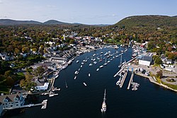
Camden is a town in Knox County, Maine, United States. The population was 5,232 at the 2020 census.[2] Located on Penobscot Bay at the mouth of the Megunticook River, Camden is one of the few places on the Atlantic seaboard where mountains meet the sea.
The town was incorporated in 1791 and named after Charles Pratt, 1st Earl Camden, a supporter of American colonial rights. Camden developed as an industrial center in the 19th century, with mills along the Megunticook River supporting shipbuilding, textile manufacturing, and lime production. The local shipyards launched notable vessels including the first six-masted schooner ever built.
Beginning in the 1880s, Camden transformed into a prominent summer colony, attracting wealthy seasonal residents from northeastern cities who built elaborate mansions along the waterfront. The town has maintained cultural significance as the birthplace of Pulitzer Prize-winning poet Edna St. Vincent Millay and home to institutions including the Camden International Film Festival. Camden's scenic harbor and historic architecture have made it a popular filming location for movies including Peyton Place, (1957) Casper (1995) and In the Bedroom (2001).
History
Pre-Settlement
The coastal region of Camden, situated on Penobscot Bay, offered rich resources and excellent geography for a future maritime community. While various regional Native groups historically utilized the coastal and forest resources, the beginning of its organized history and development started with the arrival of the first European pioneers[3].
Early settlement
Although the area was included in the Waldo Patent, European colonization did not begin until after the French and Indian War, around 1771–1772. James Richards led the first settlement effort, building a home at the mouth of the Megunticook River.[4] Other settlers followed, establishing farms on the challenging mountainous terrain. The Conway House, a Cape Cod style home built in 1770, represents one of the earliest surviving structures from this period. The building was converted into a history museum in 1962.[5]
Revolutionary War period
During the American Revolutionary War, Camden served as a strategic location. When Castine fell to the British in 1779 following the failed Penobscot expedition, Camden became a rendezvous point and encampment for American forces under Major George Ulmer. British forces conducted raids in the area, burning a local sawmill.[6]
Following the War of 1812, Camden experienced rapid industrial growth. The Megunticook River provided abundant water power for various mills, including sawmills and gristmills. By 1858, the town supported diverse manufacturing including carriage factories, sash and blind factories, and blacksmith shops. Six active shipyards launched ten to twelve vessels annually.[citation needed]
The town's industrial base expanded significantly by 1886 to include foundry products, railroad cars, woolens, paper mill feltings, anchors, maritime hardware, planking, powder kegs, excelsior, mattresses, tinware, oakum, textiles, boots, shoes, leather goods, flour, meal, corn brooms, and barrels. Camden became the second-largest producer of lime in the region after Rockland, with limestone quarried locally and processed in kilns before shipment to ports throughout the United States. This lime industry continued until 1891, when Rockport separated as an independent town.
The town's shipbuilding industry reached its peak in the late 19th century. The H.M. Bean Yard launched notable vessels including the Charlotte A. Maxwell, the largest four-masted schooner of its time, and the George W. Wells, the first six-masted schooner ever constructed.[8]
Summer colony era
Beginning in the 1880s, wealthy "rusticators" and sportsmen discovered Camden's natural beauty as a summer destination. Literary works by Sarah Orne Jewett and paintings by Fitz Hugh Lane, Frederick Church, and Childe Hassam romanticized Maine's coastal scenery, attracting visitors to local accommodations including the Bayview House Hotel, Ocean House, and Mrs. Hosmer's Boarding House.[citation needed]
Edwin Dillingham constructed the first purpose-built summer cottages in 1880 on Dillingham Point, establishing Camden as a fashionable summer colony.[citation needed] Wealthy families from Philadelphia, Boston, New York City, Washington, D.C., and Chicago built elaborate Shingle Style "cottages" along High Street, Bay View Street, and Beauchamp Point, rivaling similar developments in Bar Harbor. Summer residents typically arrived via Boston steamship lines or the Maine Central Railroad through Rockland. This seasonal influx transformed the local economy, as former mariners found employment as caretakers, gardeners, cooks, and carpenters serving the summer community.[citation needed]
The Great Fire and reconstruction
In November 1892, a devastating fire driven by strong easterly winds destroyed Camden's business district.[9] The community responded immediately, with local businessmen investing in the construction of twelve large brick buildings, including the Camden Opera House and the controversial[by whom?] Masonic Temple (later the Lord Camden Inn). Rather than deterring development, the Great Fire preceded a period of increased summer colony growth.
Infrastructure improvements followed, including a road to the summit of Mount Battie in 1897 with an accompanying inn. In 1898, Philadelphia summer residents established the Megunticook Golf Club on Beauchamp Point. The Whitehall Inn opened in 1901 in a converted sea captain's mansion on High Street, catering to affluent visitors.[citation needed]
Prominent summer families including Curtis, Bok, Keep, Gribbel, Dillingham, and Borland contributed significantly to Camden's civic infrastructure through donations that funded the public library, an amphitheater designed by Fletcher Steele, Camden Harbor Park designed by the Olmsted Brothers, the Village Green, and renovations to the Camden Opera House.[citation needed]
20th century development
World War II and Eleanor Roosevelt's visit
During World War II, Camden contributed to the war effort through shipbuilding. The Camden Shipping & Marine Railway Company was formed to build wooden barges for the military. On February 9, 1943, First LadyEleanor Roosevelt visited Camden to christen the launch of the 194-foot barge Pine Tree, one of four barges built at the Camden shipyard. The launch was a major event, drawing large crowds, press, and film crews. Mrs. Roosevelt broke the traditional champagne bottle across the bow and was splashed with champagne in the process.[10][11] During her visit, she was presented with traditional Native American gifts by members of the Penobscot tribe, including a beaded headband and receiving the name "Ow-Du-Sees-Ul" (Princess of Many Trails).[12]
Maritime recreation
Philadelphia publishing magnate Cyrus Curtis established the Camden Yacht Club in 1912, responding to the growing number of private yachts in Camden Harbor.[citation needed] The club celebrated its centennial in 2006 with the publication of "From Steam to Sail: 100 Years of the Camden Yacht Club."[13] Captain Frank Swift initiated Camden's cruise schooner industry in 1936, establishing the windjammer fleet that continues operating today.[citation needed]
Arts and literature
Camden's cultural reputation was enhanced in 1912 when Edna St. Vincent Millay first recited her poem "Renascence," written from atop Mount Battie, to guests at the Whitehall Inn. A patron's offer to fund her education at Vassar College launched her career as a Pulitzer Prize-winning poet and prominent figure of the Roaring Twenties.
French harpist, composer, and conductor Carlos Salzedo founded the internationally recognized Salzedo Summer Harp Colony in Camden, hosting annual Harp Festivals in the library amphitheater. The town became home to Bay Chamber Concerts and regular theater productions at the Opera House and Shakespeare performances in the amphitheater.
During the 1950s, Camden attracted notable artists and writers, leading to the establishment of Maine Coast Artists in nearby Rockport. Wayne Doolittle launched Down East Magazine in 1954, further promoting Maine's cultural image.
Contemporary Camden supports various cultural activities including the Camden Shakespeare Company's summer festival in the library amphitheater and the annual U.S. National Toboggan Championships at Camden Snow Bowl each February. The town served as the location for the 2001 HGTV Dream Home.
The Points North Institute, established in Camden and Rockport, founded the Camden International Film Festival in 2005, focusing on documentary filmmaking. The festival expanded to include the Points North Forum (2009), the Camden/TFI Retreat in partnership with Tribeca Film Institute (2015), and various professional development programs.[14]
In popular culture
The 2001 Best Picture Academy Award nominated film In the Bedroom had scenes that were shot in Camden. Specifically, the historic welcome arch, the bar where Tom Wilkinson's character goes looking for his son's friend, the Camden Harbor Park and Amphitheatre where Sissy Spacek's character directs the Balkan Girl's Chorus in an outdoor concert, the exterior of the bar where her son's killer is working, and the shots of the town at dawn from the summit of Mount Battie for the film's finale[15]
The majority of the 1995 film Casper was filmed in Camden, though the story takes place in Friendship. The production crew chose Camden, citing it to be "more authentic". In the film, Friendship is home to a fictional Art Nouveau mansion called Whipstaff Manor, which is haunted by four ghosts. However Whipstaff Manor is not a real mansion located on the sea front of Camden. The lower exterior and interior of the mansion was built on a set.
According to the U.S. Census Bureau, the town has a total area of 26.65 square miles (69.02km2), of which 18.24 square miles (47.24km2) is land and 8.41 square miles (21.78km2) is water.[1] Drained by the Megunticook River, Camden is located beside Penobscot Bay and the Gulf of Maine, part of the Atlantic Ocean. Principal bodies of water include: Megunticook Lake, Hosmer Pond (54 acres), Impoundment (Seabright Pond) (74 acres) and Lily Pond (32 acres). Mount Megunticook has an elevation of 1385 feet (419 m).
As of the census[20] of 2010, there were 4,850 people, 2,382 households, and 1,313 families residing in the town. The population density was 265.9 inhabitants per square mile (102.7/km2). There were 3,165 housing units at an average density of 173.5 per square mile (67.0/km2). The racial makeup of the town was 97.6% White, 0.3% African American, 0.1% Native American, 0.7% Asian, 0.2% from other races, and 1.0% from two or more races. Hispanic or Latino of any race were 1.1% of the population.
There were 2,382 households, of which 21.4% had children under the age of 18 living with them, 43.7% were married couples living together, 8.3% had a female householder with no husband present, 3.1% had a male householder with no wife present, and 44.9% were non-families. 39.2% of all households were made up of individuals, and 22.4% had someone living alone who was 65 years of age or older. The average household size was 2.01 and the average family size was 2.65.
The median age in the town was 53.2 years. 17.9% of residents were under the age of 18; 4.7% were between the ages of 18 and 24; 16.2% were from 25 to 44; 33.5% were from 45 to 64; and 27.7% were 65 years of age or older. The gender makeup of the town was 45.6% male and 54.4% female.
2000 census
At the 2000 census,[21] there were 5,254 people, 2,390 households and 1,414 families residing in the town. The population density was 287.3 inhabitants per square mile (110.9/km2). There were 2,883 housing units at an average density of 157.6 per square mile (60.8/km2). The racial makeup of the town was 98.33% White, 0.25% Black, 0.13% Native American, 0.40% Asian, 0.15% from other races, and 0.74% from two or more races. Hispanic or Latino of any race were 0.86% of the population.
There were 2,390 households, of which 24.1% had children under the age of 18 living with them, 49.1% were married couples living together, 8.5% had a divorced female householder, and 40.8% were non-families. 34.8% of all households were made up of individuals, and 16.5% had someone living alone who was 65 years of age or older. The average household size was 2.11 and the average family size was 2.71.
The age distribution was 19.7% under the age of 18, 4.4% from 18 to 24, 22.2% from 25 to 44, 30.3% from 45 to 64, and 23.4% who were 65 years of age or older. The median age was 47 years. For every 100 females, there were 83.6 males. For every 100 females age 18 and over, there were 77.1 males.
The median household income was $39,877, and the median family income was $56,439. Males had a median income of $33,500 versus $26,645 for females. The per capita income for the town was $26,126. About 5.5% of families and 8.0% of the population were below the poverty line, including 6.5% of those under age 18 and 7.2% of those age 65 or over.
Ancestry/ethnicity
As of 2017 the largest self-identified ancestry groups/ethnic groups in Camden, Maine were:[22]
Camden made national headlines in 2010 after it was announced that the town would be giving some land away (2.8 acres and a run-down leather tannery) for "free", on the condition that a prospective business owner would have to pay $175,000 to the town of Camden and create 24 "full time" jobs. As of 2012, Camden had yet to find any takers.[25] In fact, the land was still available for "free" as of 2018.
↑"History of Camden, Maine". April 7, 2021. Retrieved January 29, 2025. In 1769, James Richards brought his family from New Hampshire to live in the wilderness that is now Camden. He had fallen in love with the area when he came to cut timber for British ship masts. Richards built a sawmill and a gristmill on the Megunticook River near Washington St.
↑"History of Camden, Maine". April 7, 2021. Retrieved January 29, 2025. During the American Revolution, rebels seized British ships and sold their contents. The British plundered and burned cabins, houses, and mills. In 1779, people feared the British would annex eastern Maine to Nova Scotia and, rather than take an oath of allegiance to Britain, residents of Belfast evacuated to Camden leaving their crops in the fields. The British burned buildings at Camden Harbor. General George Ulmer erected a fort and cannon at Glen Cove and Lieutenant Benjamin Burton protected Camden Harbor.
↑"Barbara Dyer: The day when Camden burned down, 40 buildings lay in ash". PenBay Pilot. October 27, 2017. Retrieved January 29, 2025. It was in November 10, 1892 (just one year after Camden separated to become Camden and Rockport). It is claimed that it began in the basement of the Cleveland Store (later The Village Shop). It ran through the elevator shaft and burst out the roof. The Camden Fire Department arrived, but water pressure was inadequate and soon gave out. There was a fierce easterly wind that fanned the flames, so the fire crossed Main Street, went up Elm and down Washington, burning everything in its path.
↑"Eleanor Roosevelt's "My Day" column, February 10, 1943". Eleanor Roosevelt Papers Project, George Washington University. Retrieved January 29, 2025. A few were built in the last war, but the men who built them had disappeared into other trades and the present need had to ferret them out. You find your master builders sixty years of age and more, and how they love their work! One does not expect barges to be very beautiful, but this one in Camden, Maine's, shipyard had such good lines she was really graceful.
↑"Camden Shipping & Marine Railway Company". Fishermen's Voice. Retrieved January 29, 2025. The first of four barges built at Camden was launched on February 8, 1943. Although the 194-foot barge Pine Tree was ready to launch nearly a week earlier, the builders chose this day because that was when First Lady Eleanor Roosevelt was to visit Camden. On the day of the launch, Camden was inundated with eager watchers as well as members of the press and also, movie makers.
↑"Camden Harbor Collections". Camden Public Library. Retrieved January 29, 2025. Newspaper clipping from the Portland Evening Express, February 9, 1943 with photo of Mrs. Eleanor Roosevelt receiving a bead headdress and the name Ow-Du-Sees-Ul (Princess of Many Trails) from Chief Bruce Poolaw and Princess Wetawaso of the Penobscot tribe.
↑Bowditch, James L.; Plimpton, Rodney B.; Lee, Vaughan (2006). From Steam to Sail: 100 Years of the Camden Yacht Club. Camden, ME: Camden Yacht Club.
↑Barth, Jack (1991). Roadside Hollywood: The Movie Lover's State-By-State Guide to Film Locations, Celebrity Hangouts, Celluloid Tourist Attractions, and More. Contemporary Books. Page 242. ISBN9780809243266.
This page is based on this Wikipedia article Text is available under the CC BY-SA 4.0 license; additional terms may apply. Images, videos and audio are available under their respective licenses.