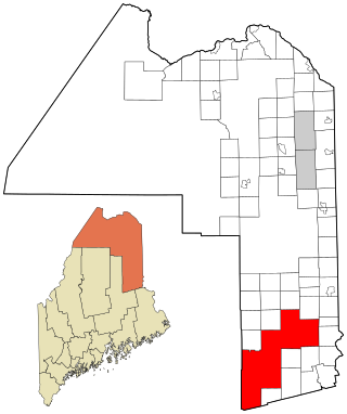
Washington County is a county located in the U.S. state of Maine. As of the 2020 census, its population was 31,095, making it the third-least populous county in Maine. Its county seat is Machias. The county was established on June 25, 1789. It borders the Canadian province of New Brunswick. It is sometimes referred to as "Sunrise County" because it includes the easternmost point in the 48 contiguous United States. Claims have been made that Washington County is where the sun first rises on the 48 contiguous states. Many small seaside communities have small-scale fishing-based economies. Tourism is also important along the county's shoreline, but it is not as important as elsewhere in the state. The blueberry crop plays a major role in the county's economy.

Knox County is a county located in the state of Maine, United States. As of the 2020 census, the population was 40,607. Its county seat is Rockland. The county is named for Revolutionary War general and Secretary of War Henry Knox, who lived in the county from 1795 until his death in 1806. The county was established on April 1, 1860, and is the most recent county to be created in Maine. It was carved from parts of Waldo and Lincoln counties. The Union Fair, started in 1868, began as the efforts of the North Knox Agricultural and Horticultural Society.
Hancock County is a county located in the U.S. state of Maine. As of the 2020 census, the population was 55,478. Its county seat is Ellsworth. The county was incorporated on June 25, 1789, and named for John Hancock, the first governor of the Commonwealth of Massachusetts.

Central Aroostook is an unorganized territory in Aroostook County, Maine, United States. The population was 164 at the 2020 census.

Connor is an unorganized territory (township) in Aroostook County, Maine, United States. The population was 418 at the 2020 census. It is the location of a former Nike missile site and the Blotner Radar Site.

Northwest Aroostook is an unorganized territory in Aroostook County, Maine, United States. The population was 12 at the 2020 census.
South Aroostook is an unorganized territory in Aroostook County, Maine, United States. The population was 579 at the 2020 census.

Square Lake is an unorganized territory in Aroostook County, Maine, United States. The population was 706 at the 2020 census.

East Central Franklin is an unorganized territory in Franklin County, Maine, United States. The population was 805 at the 2020 census.
Central Hancock, also known as Fletchers Landing, is an unorganized territory (township) in Hancock County, Maine, United States. The population was 132 at the 2020 census. The territory is designated as Township 8 Southern Division.
East Hancock is an unorganized territory in Hancock County, Maine, United States. The population was 85 at the 2020 census.
Criehaven is an alternative name for Ragged Island, an unorganized territory in Knox County, Maine, United States. Criehaven was formerly a plantation including Ragged Island just south of Matinicus Isle in outer Penobscot Bay, plus Matinicus Rock to its southeast, and Seal Island, the location of Seal Island National Wildlife Refuge, to its northeast. Criehaven surrendered its organization and reverted to an unorganized territory in 1925, but the name persists.

South Oxford is an unorganized territory located in Oxford County, Maine, United States. The population was 591 at the 2020 census. The unorganized territory encompasses the areas designated under state law as Albany Township, Mason Township, and Batchelder's Grant. Albany and Mason were formerly incorporated as towns. Albany disincorporated in 1937 while Mason disincorporated in 1935.
Prentiss is an unorganized territory (township) in Penobscot County, Maine, United States. The township was named for Henry Prentiss, an early landowner. The population was 169 at the 2020 census.
Twombly Ridge is an unorganized territory (township) located in Penobscot County, Maine, United States. At the 2020 census, the unorganized territory had a total population of 0.
Whitney is an unorganized territory in Penobscot County, Maine, United States. It is designated as Township 5 Range 1 of the North of Bingham's Penobscot Purchase. The population was 6 at the 2020 census. T5 R1 NBPP is also known as Pukakon Township.
East Central Washington is an unorganized territory in Washington County, Maine, United States. The population was 724 at the 2020 census.

Unity is an unincorporated territory (township) in Kennebec County, Maine, United States. The population was 36 at the 2020 census. The township was a former plantation that surrendered its organization in 1942.
Louds Island, also once known as Muscongus Island, is an island in Muscongus Bay off the coast of Round Pond, a village of Bristol, Maine, United States. It is also an unorganized territory of Maine. It is approximately 3 miles (4.8 km) long and 1 mile (1.6 km) wide at its widest point. The island did not have a flush toilet until 2009. The 2020 census lists Louds Island with a population of 3. It is part of the unorganized territory of Lincoln County.
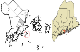
Marshall Island is an island and unorganized territory in Hancock County, Maine, United States. It lies where Penobscot Bay and Blue Hill Bay meet, between Swan's Island and Isle au Haut. Uninhabited, it is one of the largest undeveloped islands surrounding the contiguous United States.