
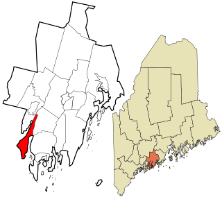
Knox County is a county located in the state of Maine, United States. As of the 2020 census, the population was 40,607. Its county seat is Rockland. The county is named for Revolutionary War general and Secretary of War Henry Knox, who lived in the county from 1795 until his death in 1806. The county was established on April 1, 1860, and is the most recent county to be created in Maine. It was carved from parts of Waldo and Lincoln counties. The Union Fair, started in 1868, began as the efforts of the North Knox Agricultural and Horticultural Society.
Hancock County is a county located in the U.S. state of Maine. As of the 2020 census, the population was 55,478. Its county seat is Ellsworth. The county was incorporated on June 25, 1789, and named for John Hancock, the first governor of the Commonwealth of Massachusetts.

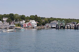
Stonington is a town in Hancock County, Maine, United States. It is located on the southern portion of the island of Deer Isle. The population was 1,056 at the 2020 census. It includes the villages of Burnt Cove, Oceanville, Green Head, and Clam City. A picturesque working waterfront and tranquil tourist destination in eastern Penobscot Bay, Stonington has consistently ranked among the top lobster ports in the country and is the largest lobster port in Maine. In 2011, 14,854,989 pounds of lobster were landed by Stonington fishermen, with a value of $46.3 million.

Verona Island is a town located on an island of the same name in the Penobscot River in Hancock County, Maine, United States. The population was 507 at the 2020 census.

Friendship is a town in Knox County, Maine, United States. It is 31 miles (49.9 km) southeast of Augusta. The population was 1,142 at the 2020 census.

Isle au Haut is a town in Knox County, Maine, United States, on an island of the same name in Penobscot Bay. The population was 92 at the 2020 census. Home to portions of Acadia National Park, Isle au Haut is accessible by ferry from Stonington. The 6 mile ride takes about 45 minutes.

Matinicus Isle is an island plantation in Knox County, Maine, United States. The island is located within Penobscot Bay about 20 miles east of the mainland coast and is accessible by state ferry service from Rockland or by air taxi from Knox County Regional Airport. Matinicus is the farthest inhabited land off the east coast into the Atlantic Ocean which is part of the United States. The plantation is both a year-round island community and a summer colony. The population was 53 at the 2020 census.
North Haven is a town and island in Knox County, Maine, United States, in Penobscot Bay. The town is both a year-round island community and a prominent summer colony. The population was 417 at the 2020 census. North Haven is accessible by thrice-daily state ferry service from Rockland, or by air taxi from Knox County Regional Airport.

Rockland is a city in and the county seat of Knox County, Maine, United States. As of the 2020 census, the town population was 6,936. The city is a popular tourist destination. It is a departure point for the Maine State Ferry Service to the islands of Penobscot Bay: Vinalhaven, North Haven and Matinicus.

Vinalhaven is a town in Knox County, Maine, United States. Its town limits include the island of Vinalhaven, the largest of the Fox Islands, and smaller islands, some accessible from Vinalhaven island by bridge or causeway. The population was 1,279 at the 2020 census. It is home to a thriving lobster fishery and hosts a summer colony. Since there is no bridge to the island, Vinalhaven is primarily accessible from Rockland via an approximately 75-minute state ferry ride across West Penobscot Bay, or by air taxi from Knox County Regional Airport.

Monhegan is an island in the Gulf of Maine. A plantation, a minor civil division in the state of Maine falling between unincorporated area and a town, it is located approximately 12 nautical miles (22 km) off the mainland and is part of Lincoln County, Maine, United States. The population was 64 at the 2020 census. The plantation comprises its namesake island and the neighboring island of Manana. The island is accessible by scheduled boat service from Boothbay Harbor, New Harbor and Port Clyde. Visitors' cars are not allowed on the island. It was designated a United States National Natural Landmark for its coastal and island flora in 1966.
West Central Franklin is an unorganized territory located in Franklin County, Maine, United States. As of the 2020 census, the location had a total population of 1. Most of this area has never been organized. The only exception was a short-lived incorporated town in the 19th century.
East Central Washington is an unorganized territory in Washington County, Maine, United States. The population was 724 at the 2020 census.
Westport Island, formerly Westport, is a town in Lincoln County, Maine, United States. In the 19th century the island was known as Jeremysquam, a nickname islanders still use for it. The population was 719 at the 2020 census.

Penobscot Bay is an inlet of the Gulf of Maine and Atlantic Ocean in south central Maine, a stretch known as Midcoast Maine, in a broader Atlantic region known as Down East. The bay originates from the mouth of Maine's Penobscot River, downriver from Belfast. Penobscot Bay has many working waterfronts including Rockland, Rockport, and Stonington, and Belfast. Penobscot Bay is between Muscongus Bay and Blue Hill Bay, just west of Acadia National Park.

The town is the basic unit of local government and local division of state authority in the six New England states. Most other U.S. states lack a direct counterpart to the New England town. New England towns overlay the entire area of a state, similar to civil townships in other states where they exist, but they are fully functioning municipal corporations, possessing powers similar to cities and counties in other states. New Jersey's system of equally powerful townships, boroughs, towns, and cities is the system which is most similar to that of New England. New England towns are often governed by a town meeting, an assembly of eligible town residents. The great majority of municipal corporations in New England are based on the town model; there, statutory forms based on the concept of a compact populated place are uncommon, though elsewhere in the U.S. they are prevalent. County government in New England states is typically weak, and in some states nonexistent. Connecticut, for example, has no county governments, nor does Rhode Island. Both of those states retain counties only as geographic subdivisions with no governmental authority, while Massachusetts has abolished eight of fourteen county governments so far. Counties serve mostly as dividing lines for the states' judicial systems and some other state services in the southern New England states while providing varying services in the more sparsely populated three northern New England states.
Louds Island, also once known as Muscongus Island, is an island in Muscongus Bay off the coast of Round Pond, a village of Bristol, Maine, United States. It is also an unorganized territory of Maine. It is approximately 3 miles (4.8 km) long and 1 mile (1.6 km) wide at its widest point. The island did not have a flush toilet until 2009. The 2020 census lists Louds Island with a population of 3. It is part of the unorganized territory of Lincoln County.

Muscle Ridge Islands is an archipelago and unorganized territory off the coast of South Thomaston in Knox County, Maine, United States. The population was 9 at the 2020 census.
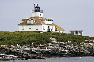
Marshall Island is an island and unorganized territory in Hancock County, Maine, United States. It lies where Penobscot Bay and Blue Hill Bay meet, between Swan's Island and Isle au Haut. Uninhabited, it is one of the largest undeveloped islands surrounding the contiguous United States.

