Rockport, Maine

Last updated
Rockport, Maine
Rockport Harbor.JPG
View of Rockport Harbor
Knox County Maine incorporated and unincorporated areas Rockport highlighted.svg
Location in Knox County and the state of Maine
Coordinates: 44°11′04″N69°04′34″W / 44.18444°N 69.07611°W / 44.18444; -69.07611
Country United States
State Maine
County Knox
Incorporated1891
VillagesRockport
Glen Cove
Oakland Park
Rockville
West Rockport
Area
[1]
  Total33.34 sq mi (86.35 km2)
  Land21.64 sq mi (56.05 km2)
  Water11.70 sq mi (30.30 km2)
Elevation
223 ft (68 m)
Population
 (2020)
  Total3,644
  Density168/sq mi (65.0/km2)
Time zone UTC−5 (Eastern (EST))
  Summer (DST) UTC−4 (EDT)
ZIP Code
04856
Area code 207
FIPS code 23-63660
GNIS feature ID0582699
Website town.rockport.me.us

Rockport is a town in Knox County, Maine, United States. It is 35 miles (56.3 km) southeast of Augusta. The population was 3,644 at the 2020 census. [2] Rockport is a popular tourist destination and art colony.

Contents

History

Rockport, or "the River", was settled in 1769 by Robert Thorndike. Goose River Village (as it was known until 1852) was originally part of the Megunticook Plantation, incorporated in 1791 as Camden. Shipbuilding, ice harvesting and the manufacture of lime were important early industries. [3] In 1817, three hundred casks of lime were sent to Washington, DC for use in the rebuilding of the United States Capitol, which had been damaged by the British during the War of 1812. In 1852, the citizens of Goose River voted to change their village's name to Rockport for its rocky terrain. [4] On February 25, 1891, Rockport officially split from Camden because of a dispute over the cost of constructing a bridge. The town of Rockport was born and from Camden it took half the population, three quarters of the land, and most importantly the profitable lime and ice industries.

Rockport has a longstanding reputation as an artists' community, with notable artists and art institutions playing a significant role in the town's economic and social life. Bay Chamber Concerts was established in 1961 as a continuation of the summer music instruction of the Curtis Institute. Mary Louise Curtis Bok, central to founding both Bay Chamber Concerts and the Curtis Institute, was one of the largest landowners in Rockport, and has been credited with playing a vital role in significantly improving the landscaping of the village's inner harbor. [5] At one time she owned most of the eastern shore of the harbor. Mary Lea Park, adjacent to the Rockport Opera House, is named in honor of both her and Rockport resident and violinist Lea Luboshutz. [6]

Rockport was the home of Andre the Seal, a seal adopted by the Goodridge family in 1961, and who was a significant tourist attraction in Rockport Harbor until his death in 1986. The seal's "owner" Harry Goodridge co-wrote a book about Andre, titled A Seal Called Andre. The 1994 film Andre was adapted from the book, although in the movie Andre is actually played by a sea lion, not a seal. A statue of Andre sits beside the harbor in his honor. [7] Rockport is also known for its Belted Galloway cattle. The cattle are raised at the 136-acre Aldermere Farm, which is owned and operated by the Maine Coast Heritage Trust, a statewide land conservation organization. The Belted Galloways remain one of the area's most popular attractions, and are often referred to as the "Oreo cookie" cows. [8]

The 1993 Warner Bros. film The Man Without a Face , starring Mel Gibson, Universal's 1995 film Casper , and Miramax's 2001 film In the Bedroom were filmed in Rockport.

In 2008, Forbes magazine placed Rockport at the top of its list of the prettiest towns in America. [9]

Geography

According to the United States Census Bureau, the town has a total area of 33.34 square miles (86.35 km2), of which 21.64 square miles (56.05 km2) is land and 11.70 square miles (30.30 km2) is water. [1] Drained by Varnah Brook and Goose River, Rockport is located beside Penobscot Bay and the Gulf of Maine, part of the Atlantic Ocean.

The town is crossed by U. S. Route 1 and state routes 17 and 90. It borders the towns of Rockland to the south, Warren to the southwest, Union to the west, Hope to the northwest, and Camden to the north.

Climate

This climatic region is typified by large seasonal temperature differences, with warm to hot (and often humid) summers and cold (sometimes severely cold) winters. According to the Köppen Climate Classification system, Rockport has a humid continental climate, abbreviated "Dfb" on climate maps. [10]

Demographics

Historical population
CensusPop.Note
1900 2,314
1910 2,022−12.6%
1920 1,774−12.3%
1930 1,651−6.9%
1940 1,526−7.6%
1950 1,6568.5%
1960 1,89314.3%
1970 2,0679.2%
1980 2,74933.0%
1990 2,8543.8%
2000 3,20912.4%
2010 3,3303.8%
2020 3,6449.4%
U.S. Decennial Census [11]

2010 census

As of the census [12] of 2010, there were 3,330 people, 1,422 households, and 967 families residing in the town. The population density was 153.9 inhabitants per square mile (59.4/km2). There were 1,956 housing units at an average density of 90.4 per square mile (34.9/km2). The racial makeup of the town was 97.6% White, 0.3% African American, 0.5% Native American, 0.4% Asian, and 1.2% from two or more races. Hispanic or Latino of any race were 1.1% of the population.

There were 1,422 households, of which 27.7% had children under the age of 18 living with them, 56.1% were married couples living together, 8.7% had a female householder with no husband present, 3.2% had a male householder with no wife present, and 32.0% were non-families. Of all households, 25.6% were made up of individuals, and 10.5% had someone living alone who was 65 years of age or older. The average household size was 2.34 and the average family size was 2.80.

The median age in the town was 48.8 years. 22% of residents were under the age of 18; 4.5% were between the ages of 18 and 24; 17.8% were from 25 to 44; 35.8% were from 45 to 64; and 19.9% were 65 years of age or older. The gender makeup of the town was 48.2% male and 51.8% female.

2000 census

In the 2000 census, there were 3,209 people, 1,373 households and 918 families in the town. The population density was 147.8 inhabitants per square mile (57.1/km2). There were 1,677 housing units at an average density of 77.2 per square mile (29.8/km2). The racial makeup was 98.69% White, 0.16% African American, 0.06% Native American, 0.44% Asian, 0.19% from other races, and 0.47% from two or more races. Hispanic or Latino of any race were 0.75% of the population.

There were 1,373 households, of which 29.6% had children under 18 living with them, 56.2% were married couples living together, 8.2% had a female householder with no husband present, and 33.1% were non-families. Of all households, 27.7% were made up of individuals, and 11.5% had someone living alone who was 65 years of age or older. The average household size was 2.33 and the average family size was 2.83.

In the town, the population was spread out, with 23.5% under 18, 5.0% from 18 to 24, 25.3% from 25 to 44, 28.9% from 45 to 64, and 17.3% who were 65 or older. The median age was 43. For every 100 females, there were 91.7 males. For every 100 females 18 and over, there were 89.0 males.

The median income for a household in the town was $47,155, and the median for a family $56,068. Males had a median of $35,865 versus $25,542 for females. The per capita income for the town was $25,498. About 5.4% of families and 7.1% of the population were below the poverty line, including 10.2% of those under 18 and 7.3% of those 65 or over.

Sites of interest

Tidal Island Tidal Island in Rockport Harbor, Rockport Maine.JPG
Tidal Island
View of the harbor Rockport Maine.jpg
View of the harbor
McCobb Spite House McCobb Spite House July 1960.JPG
McCobb Spite House

Education

Notable people

Related Research Articles

<span class="mw-page-title-main">Knox County, Maine</span> County in Maine, United States

Knox County is a county located in the state of Maine, United States. As of the 2020 census, the population was 40,607. Its county seat is Rockland. The county is named for Revolutionary War general and Secretary of War Henry Knox, who lived in the county from 1795 until his death in 1806. The county was established on April 1, 1860, and is the most recent county to be created in Maine. It was carved from parts of Waldo and Lincoln counties. The Union Fair, started in 1868, began as the efforts of the North Knox Agricultural and Horticultural Society.

<span class="mw-page-title-main">Hancock County, Maine</span> County in Maine, United States

Hancock County is a county located in the U.S. state of Maine. As of the 2020 census, the population was 55,478. Its county seat is Ellsworth. The county was incorporated on June 25, 1789, and named for John Hancock, the first governor of the Commonwealth of Massachusetts.

<span class="mw-page-title-main">Gouldsboro, Maine</span> Town in the state of Maine, United States

Gouldsboro is a town and municipality in Hancock County, Maine, United States on the Schoodic Peninsula. The town was named for Robert Gould, a landholder in the town. The town has many historically separate fishing villages, summer colonies and communities, including Birch Harbor, Prospect Harbor, South Gouldsboro, West Gouldsboro, Summer Harbor, Wonsqueak Harbor, Bunker's Harbor, Chicken Mill, Jones' Pond, Westbay, and Corea. The population was 1,703 at the 2020 census.

<span class="mw-page-title-main">Lamoine, Maine</span> Town in the state of Maine, United States

Lamoine is a town in Hancock County, Maine, United States. The town was named after an early resident, Andre LeMoyne. The spelling shifted slightly over the years. "Le moine" is French for "the monk." The population was 1,720 at the 2020 census.

<span class="mw-page-title-main">Mount Desert, Maine</span> Town in the state of Maine, United States

Mount Desert is a town on Mount Desert Island in Hancock County, Maine, United States. The population was 2,146 at the 2020 census. Incorporated in 1789, the town currently encompasses the villages of Otter Creek, Seal Harbor, Northeast Harbor, Somesville, Hall Quarry, and Pretty Marsh.

<span class="mw-page-title-main">Southwest Harbor, Maine</span> Town in the state of Maine, United States

Southwest Harbor is a town in Hancock County, Maine, United States. Located on Mount Desert Island, the population was 1,756 at the 2020 census. The municipality contains within it the villages of Southwest Harbor, Manset, Seawall, Wonderland, and Pemetic Hills.

<span class="mw-page-title-main">Tremont, Maine</span> Town in the state of Maine, United States

Tremont is a town in Hancock County, Maine, United States. It is located on the southwestern side of Mount Desert Island, known to locals as "the quiet side."

<span class="mw-page-title-main">Trenton, Maine</span> Town in the state of Maine, United States

Trenton is a town in Hancock County, Maine, United States, near Acadia National Park. The population was 1,584 at the 2020 census. Hancock County-Bar Harbor Airport is located in Trenton.

<span class="mw-page-title-main">Winter Harbor, Maine</span> Town in the state of Maine, United States

Winter Harbor is a town on the Schoodic Peninsula in Hancock County, Maine, United States. The population was 461 at the 2020 census. The town is located just outside the Schoodic Peninsula portion of Acadia National Park and is due east of the town of Bar Harbor and Ellsworth. Winter Harbor was once the location of a US Naval Station, NSGA-WH, which closed in the mid-2000s, and is now home to the Schoodic Institute’s Education and Research Center.

<span class="mw-page-title-main">Sidney, Maine</span> Town in the state of Maine, United States

Sidney is a town in Kennebec County, Maine, United States. The population was 4,645 at the 2020 census. Sidney was incorporated as a town on January 30, 1792. The town was named for Sir Philip Sidney, an English author. Sidney is included in the Augusta, Maine micropolitan New England City and Town Area. Since 1937, the town has been the home of the New England Music Camp.

<span class="mw-page-title-main">Hope, Maine</span> Town in Maine, United States

Hope is a town in Knox County, Maine, United States. The population was 1,698 at the 2020 census.

<span class="mw-page-title-main">Rockland, Maine</span> City in Maine, United States

Rockland is a city and county seat of Knox County, Maine, United States. As of the 2020 census, the town population was 6,936. The city is a popular tourist destination. It is a departure point for the Maine State Ferry Service to the islands of Penobscot Bay: Vinalhaven, North Haven and Matinicus.

<span class="mw-page-title-main">St. George, Maine</span> Town in the state of Maine, United States

St. George is a town in Knox County, Maine, United States. It includes the villages of Port Clyde and Tenants Harbor, with the latter being town's commercial center. A favorite with artists, writers and naturalists, St. George is home to the Brothers and Hay Ledge nature preserve, comprising four islands off Port Clyde. The town's population stands at 2,594 residents, according to the 2020 Census.

<span class="mw-page-title-main">Boothbay, Maine</span> Town in Maine, United States

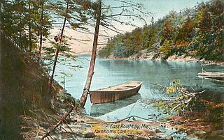
Boothbay is a town in Lincoln County, Maine, United States. The population was 3,003 at the 2020 census. It includes the neighborhoods of Back Narrows, Dover, Linekin, Oak Hill, Ocean Point, Spruce Shores, and the villages of East Boothbay and Trevett. The surrounding Boothbay Region is a center of summer tourist activity, and a significant part of its population does not live there year-round. Five shipyards are located in the town, the largest of which is Washburn & Doughty.

<span class="mw-page-title-main">Lincolnville, Maine</span> Town in the state of Maine, United States

Lincolnville is a town in Waldo County, Maine, United States. The population was 2,312 at the 2020 census. Lincolnville is the mainland terminal for Maine State Ferry Service transport to Islesboro.

<span class="mw-page-title-main">Cutler, Maine</span> Town in the state of Maine, United States

Cutler is a town in Washington County, Maine, United States. The town was named after Joseph Cutler, an early settler, who hailed from Newburyport, Massachusetts. The population was 524 at the 2020 census.

<span class="mw-page-title-main">Camden, Maine</span> Town in Maine, United States

Camden is a town in Knox County, Maine, United States. The population was 5,232 at the 2020 census. The population of the town more than triples during the summer months, due to tourists and summer residents. Camden is a summer colony in the Mid-Coast region of Maine. Similar to Bar Harbor, Nantucket and North Haven, Camden is well known for its summer community of wealthy Northeasterners, mostly from Boston, New York City, and Philadelphia.

<span class="mw-page-title-main">Camden (CDP), Maine</span> Census-designated place in Maine, United States

Camden is a census-designated place (CDP) comprising the main village in the town of Camden in Knox County, Maine, United States. The population was 3,570 at the 2010 census, out of 4,850 in the entire town of Camden.

<span class="mw-page-title-main">Boothbay Harbor (CDP), Maine</span> Census-designated place in Maine, United States

Boothbay Harbor is a census-designated place (CDP) comprising the densely populated center of the town of Boothbay Harbor in Lincoln County, Maine, United States. The population was 1,086 at the 2010 census, down from 1,237 at the 2000 census.

<span class="mw-page-title-main">Boothbay Harbor, Maine</span> Town in Maine, United States

Boothbay Harbor is a town in Lincoln County, Maine, United States. The population was 2,027 at the 2020 census. It includes the neighborhoods of Bayville, Mount Pisgah, and Sprucewold, and the villages of Isle of Springs and West Boothbay Harbor. During summer months, the entire Boothbay Harbor region is a popular yachting and tourist destination.

References

  1. 1 2 "US Gazetteer files 2010". United States Census Bureau . Retrieved 2012-12-16.
  2. "Census - Geography Profile: Rockport town, Knox County, Maine" . Retrieved January 15, 2022.
  3. Maine League of Historical Societies and Museums (1970). Doris A. Isaacson (ed.). Maine: A Guide 'Down East'. Rockland, Me: Courier-Gazette, Inc. pp. 264–265.
  4. Varney, George J. (1886), Gazetteer of the state of Maine. Camden (and Rockport), Boston: Russell
  5. Hebert, Richard A. Modern Maine: Its Historic Background People and Resources , Vol. II, p. 396. New York: Lewis Historical Publishing Company, Inc., 1951.
  6. A History of Bay Chamber Concerts
  7. Marine Life Series: Andre the Harbor Seal
  8. Aldermere Farm History
  9. "Forbes: "America's Prettiest Towns"". Archived from the original on 2009-07-05. Retrieved 2009-08-02.
  10. Climate Summary for Rockport, Maine
  11. "Census of Population and Housing". Census.gov. Retrieved June 4, 2015.
  12. "U.S. Census website". United States Census Bureau . Retrieved 2012-12-16.
  13. Aldermere Farm -- Maine Coast Heritage Trust
  14. Camden Area History Center
  15. Camden-Rockport Historical Society
  16. Center for Maine Contemporary Art
  17. Indian Island Light
  18. Rockport Opera House Archived 2007-06-17 at the Wayback Machine
  19. Camden Hills Regional High School