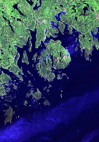
Casco Bay is an inlet of the Gulf of Maine on the southern coast of Maine, New England, United States. Its easternmost approach is Cape Small and its westernmost approach is Two Lights in Cape Elizabeth. The city of Portland sits along its southern edge and the Port of Portland lies within.

Sebago Lake (Sih-Bay-Goh) is the deepest and second-largest lake in the U.S. state of Maine. The lake is 316 feet (96 m) deep at its deepest point, with a mean depth of 101 feet (31 m). It is possible that Sebago is the deepest lake wholly contained within the entire New England region, although some sources say that Vermont's Lake Willoughby is slightly deeper. Along with Lake Champlain, Sebago is one of the only lakes in the area that does not consistently freeze solid during the winter months, with total ice cover only occurring for a short period of time every few winters. Sebago covers about 45 square miles (117 km2) in surface area, has a length of 14 miles (23 km) and has a shoreline length of roughly 105 miles (169 km). The surface is around 270 feet (82 m) above sea level, so the deep bottom is below the present sea level. It is in Cumberland County, and bordered by the towns of Casco, Naples, Raymond, Sebago, Standish and Windham. The seasonally occupied town of Frye Island is on an island in the lake. Sebago Lake and the surrounding area is known for its erratic and sudden changes in weather during all seasons, likely due to its proximity to the Atlantic Ocean and to Mt. Washington, a very notorious extreme weather hotspot. The name comes from the Abenaki sobagoo, meaning "it is the sea" or "it resembles the sea".

Chebeague Island is located in Casco Bay, an inlet of the Gulf of Maine. It was originally used as a fishing ground by Abenaki Native Americans. Also known as Great Chebeague Island, today it is a town in Cumberland County, Maine, United States. It is located 10 miles (16 km) northeast of Portland, Maine. Chebeague Island is the largest island in Casco Bay that is not connected to the mainland by a bridge. The largest island is Sebascodegan, or "Great Island," which is part of the Town of Harpswell and connected to the mainland by a bridge.

Cushing Island, or Cushing's Island, is a privately owned island in Casco Bay in the U.S. state of Maine. Part of the city of Portland, roughly 45 families live there seasonally.
Casco Bay Lines is a publicly run transportation company that services the residents of the islands of Casco Bay, Maine. These islands include Peaks Island, Little Diamond Island, Great Diamond Island, Diamond Cove, Long Island, Chebeague Island, and Cliff Island.

Eagle Island is an island in Maine's Casco Bay and the site of the summer home of the polar explorer Admiral Robert Peary (1856-1920). The island and home are preserved as the Eagle Island State Historic Site

The Presumpscot River is a 25.8-mile-long (41.5 km) river located in Cumberland County, Maine, United States. It is the main outlet of Sebago Lake. The river provided an early transportation corridor with reliable water power for industrial development of the city of Westbrook and the village of South Windham.
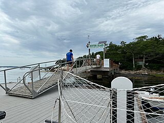
Bustins Island is an island in inner Casco Bay, Maine, United States. It is part of the town of Freeport. Although physically located within Freeport, the Bustins Island Village Corporation is a self-governing entity. The island has approximately 117 summer cottages, with the earliest dating to the 18th century.
The Maine Department of Transportation, also known as MaineDOT, is the office of state government charged with the regulation and maintenance of roads, rail, ferries, and other public transport infrastructure in the state of Maine. An exception is the Maine Turnpike, which is maintained by the Maine Turnpike Authority. MaineDOT reports on the adequacy of roads, highways, and bridges in Maine. It also monitors environmental factors that affect the motor public such as stormwater, ice/snow buildup on roads, and crashes with moose. MaineDOT was founded in 1972 and replaced the former Maine State Highway Commission.
The Maine Island Trail is a recreational water trail that spans the entire coast of Maine, connecting over 200 islands and mainland sites available for day visits or overnight camping. The trail is operated by the Maine Island Trail Association (MITA), a non-profit membership organization based in Portland, Maine, with over 6,000 members. Trail properties are owned by private landowners, conservation organizations, and federal, state and municipal agencies, all of whom make their land available to MITA members in exchange for Leave No Trace use and careful stewardship. All sites—many of which are concentrated between Casco Bay and Mount Desert Island—are accessible by personal watercraft, such as sea kayaks, sailboats or powerboats.

Cousins Island is an island in Casco Bay within the town of Yarmouth in Cumberland County, Maine, United States. It is listed as a census-designated place, with a population of 490 as of the 2010 census. The CDP is part of the Portland–South Portland–Biddeford, Maine Metropolitan Statistical Area.

Fort Levett was a former U.S. Army fort built on Cushing Island, Maine, beginning in 1898. Located in Cumberland County, Maine, in Casco Bay near Portland, Maine, the fort was heavily fortified with guns for coastal defense. Conceived under the Endicott Program in 1885 and begun in the wake of the Spanish–American War, Fort Levett was manned during both world wars. It was part of the Coast Defenses of Portland, later renamed the Harbor Defenses of Portland, a command which protected Portland's port and naval anchorage 1904-1950. The fort's name is sometimes misspelled as "Fort Leavitt".

Battery Steele is a United States military fortification on Peaks Island, Portland, Maine in Casco Bay. Completed in 1942 as part of World War II, it is located on 14 acres (5.7 ha) on the oceanside area of the island, formerly part of the Peaks Island Military Reservation. It is named for Harry L. Steele, who was a Coast Artillery officer during World War I. It was armed with two 16-inch MkIIMI guns and, with a 12-inch gun battery at Fort Levett on Cushing Island, replaced all previous heavy guns in the Harbor Defenses of Portland. It was built to protect Casco Bay, particularly Portland harbor, from Kennebunk to Popham Beach in Phippsburg. According to Kim MacIsaac and historian Joel Eastman in An Island at War, “Battery Steele is not only the largest gun battery built on Peaks Island, but also an example of the largest battery ever built anywhere in the United States.” In 1995, after decades of non-use, the Peaks Island Land Preserve, a community land preservation group, formed to purchase the area and forever preserve it as a public space. On October 20, 2005, the property was listed on the National Register of Historic Places. Other coast defense structures on the island include fire control towers and the counterweight for a disappearing searchlight tower.
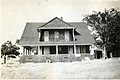
The Great Chebeague Golf Club is a country club at 16 Stone Wharf Road on Chebeague Island, Maine. It has a nine-hole golf course on more than 28 acres (11 ha) on the north side of the island. Its clubhouse is a repurposed circa 1807 residence, which is probably one of the oldest buildings used for that purpose in the nation. The club was listed on the National Register of Historic Places in 2015.
The Maine Coast Heritage Trust is a nonprofit land conservation organization. Its conservation partner is the Maine Land Trust Network, which is one of its programs.

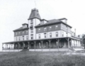
The Chebeague Island Inn is located on Chebeague Island, Maine, United States. Situated in 2.5 acres (0.0039 sq mi), on South Road, near the northern tip of the island, the inn overlooks part of Casco Bay. Just beyond the inn's property, Stone Wharf Landing is where the Chebeague Island Ferry, which runs to and from Cousins Island, berths on the island. The inn also overlooks a few holes of the island's nine-hole golf course.

The Casco Bay Mailboat is a sailing vessel, run by Casco Bay Lines, which delivers mail and other items to the residents of the islands of Casco Bay in Maine, United States. It is the longest-running mailboat service in the country, having been in existence since the 1870s. Up until the 1950s, the boat was coal-powered; now it runs on a diesel engine.

The Chebeague & Cumberland Land Trust is a volunteer-run conservation group based in Cumberland, Maine, United States. Established in 1987 and funded by its members, it owns many preserves and trail networks, and has assisted in the creation of town-owned parks and preserves. The trust, one of eighty land trusts in Maine, covers the towns of Cumberland and Chebeague Island.
Archie Elbert Ross was an American sea captain and shipwright. He was captain of the ferry which runs between Bustins Island and South Freeport, Maine, for over fifty years. Bustins Island's public landing is now named for him.

Public transportation in Maine is available for all four main modes of transport—air, bus, ferry and rail—assisting residents and visitors without their own vehicle to travel around much of Maine's 31,000 square miles (80,000 km2). Indeed, as of 2015, almost 75% of Mainers dependent upon public transport lived in areas without a bus service. There are sixteen local public transportation providers, of which seven are in rural locations.